Guatemala
Antigua
Colonial ruins and Holy Week between three volcanoes
Days Start with the basic programme and choose extensions for the time you have.
How the guide reaches this number
Antigua isn't for anyone after late nights, beaches or a big city, because almost everything closes between midnight and 1am. With just one day, I'd start under the Arco de Santa Catalina before 7am and, at 8am, climb to the cross lookout with the tourist police escort. At 10am, I'd head down to Parque Central and the cathedral ruins, have the menú del día at a comedor at 12:30pm, and in the afternoon walk to the Convento de las Capuchinas to see the Torre de Retiro. After 6pm, I'd go back to Parque Central, when the tostada stalls come out. The letdown is 5a Avenida itself, where many of the houses have become tour agencies and jade shops; around the Arch, it stays packed from 8am to 8pm. This is also the most expensive city in Guatemala, and during Holy Week room rates double or triple, so decide early whether your trip falls in that week.
2–3
When November to February, the dry season with the volcano in view; in March and April smoke from crop burning hides it, and Holy Week fills the city and multiplies prices by two or three
How the guide reaches this number
At 1,530 m, the thermometer barely moves, between about 10°C and 27°C all year, and what changes from month to month is the rain. The best season runs from November to February, the first half of the dry season: clear skies, mornings of 10–13°C in December and January, afternoons of 24–26°C, and Volcán de Agua visible whole from morning to evening. The dry season continues in March and April, the hottest months, but dust and smoke from agricultural burning blot out the mountains, and in April the volcano often disappears on a day without a single cloud. The rainy season runs from May to October, with sunny mornings and an almost daily downpour between 3pm and 7pm; June and September are the wettest months, and from August to October there's a risk of tropical storms from the Caribbean or the Pacific, so skip September. High season has three peaks: Holy Week, July and August, and Christmas through New Year. Holy Week is the most sought-after, with lodging sold out far in advance. To catch the town at its quietest within the good window, go in the first half of November; outside it, May and early June have few crowds and sunny mornings before the afternoon storm.
Per person/day Q250–400 backpacking, Q600–1,000 in mid-range comfort (roughly US$33–130)
How the guide reaches this number
Per person per day: accommodation, meals, urban transport, visits and a small allowance for extras. Flights excluded; larger purchases vary. Editorial estimate, not a quote.
 What Nilo thinks
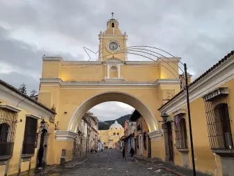
Stay two days, with time to spare: one for the damero, the checkerboard center, and another for the convents and coffee; if you have a third, spend it in the valley villages. Antigua isn't for anyone after late nights, beaches or a big city, because almost everything closes between midnight and 1am. With just one day, I'd start under the Arco de Santa Catalina before 7am and, at 8am, climb to the cross lookout with the tourist police escort. At 10am, I'd head down to Parque Central and the cathedral ruins, have the menú del día at a comedor at 12:30pm, and in the afternoon walk to the Convento de las Capuchinas to see the Torre de Retiro. After 6pm, I'd go back to Parque Central, when the tostada stalls come out. The letdown is 5a Avenida itself, where many of the houses have become tour agencies and jade shops; around the Arch, it stays packed from 8am to 8pm. This is also the most expensive city in Guatemala, and during Holy Week room rates double or triple, so decide early whether your trip falls in that week.In Antigua, 5a Avenida Norte passes under the Arco de Santa Catalina, built in 1694, and the cone of Volcán de Agua closes the view at the end of the street. Spain governed Central America from here until the 1773 earthquakes sent the administration to another valley, and the town left behind stayed small and low, full of churches and ruined convents that the law requires to be left as they are, roofless. At La Recolección, the vault blocks still lie on the ground where the tremors left them. Since 1969 the CNPAG conservation council has approved the color of every facade and banned neon, tall buildings and traffic lights, which is why nights here are dark and quiet. Everything is done on foot, over the rounded stones of the damero, and between one convent and another you can try pepián at a comedor, tostadas from the Parque Central stalls and the arabica coffee grown on the valley's volcanic slopes. Come between November and February, in the dry season and before the smoke from the burning season, and allow two days.
Quick facts
- Population
- about 46,000 in the municipality (2026); about 370,000 in the Sacatepéquez department
- Founded
- March 10, 1543, as Santiago de los Caballeros de Guatemala, in the Panchoy Valley
- Country and region
- Guatemala, Central America; capital of the Sacatepéquez department, at 1,530 m elevation
- Language
- Spanish; Kaqchikel in nearby villages, such as Santa María de Jesús and San Antonio Aguas Calientes
- Currency
- Quetzal (GTQ, written Q); about 7.7 Q per dollar and about 1.4 Q per real in 2026
- Time zone
- UTC−6 year-round, with no daylight saving; 3 hours behind Brasília
- Best time to visit
- November to February, the dry season with the volcano in view; in March and April smoke from crop burning hides it, and Holy Week fills the city and multiplies prices by two or three
- Average daily cost
- Q250–400 backpacking, Q600–1,000 in mid-range comfort (roughly US$33–130)
When to go
November to February, the dry season with the volcano in view; in March and April smoke from crop burning hides it, and Holy Week fills the city and multiplies prices by two or three
March
21° to 30°C
161 mm of rain
April
23° to 32°C
143 mm of rain
May
24° to 32°C
205 mm of rain
June
24° to 32°C
264 mm of rain
July
23° to 32°C
410 mm of rain
August
24° to 32°C
389 mm of rain
September
24° to 32°C
326 mm of rain
October
23° to 31°C
374 mm of rain
How the year changes
At 1,530 m, the thermometer barely moves, between about 10°C and 27°C all year, and what changes from month to month is the rain. The best season runs from November to February, the first half of the dry season: clear skies, mornings of 10–13°C in December and January, afternoons of 24–26°C, and Volcán de Agua visible whole from morning to evening. The dry season continues in March and April, the hottest months, but dust and smoke from agricultural burning blot out the mountains, and in April the volcano often disappears on a day without a single cloud. The rainy season runs from May to October, with sunny mornings and an almost daily downpour between 3pm and 7pm; June and September are the wettest months, and from August to October there's a risk of tropical storms from the Caribbean or the Pacific, so skip September. High season has three peaks: Holy Week, July and August, and Christmas through New Year. Holy Week is the most sought-after, with lodging sold out far in advance. To catch the town at its quietest within the good window, go in the first half of November; outside it, May and early June have few crowds and sunny mornings before the afternoon storm.
The same numbers as a table
| Month | Temperature °C | Rain mm |
|---|---|---|
| January · | 19 to 28 | 294 |
| February · | 20 to 29 | 185 |
| March | 21 to 30 | 161 |
| April | 23 to 32 | 143 |
| May | 24 to 32 | 205 |
| June | 24 to 32 | 264 |
| July | 23 to 32 | 410 |
| August | 24 to 32 | 389 |
| September | 24 to 32 | 326 |
| October | 23 to 31 | 374 |
| November · | 21 to 29 | 400 |
| December · | 20 to 28 | 264 |
Nilo's tips
Arco de Santa Catalina before 7am.
Before 7am, 5a Avenida Norte is still empty and Volcán de Agua rises cloudless behind the Arch, the shot every visitor wants. From 8am to 8pm the street becomes a pedestrian corridor, and the photo fills with people. In March and April, smoke from agricultural burning erases the horizon even on dry days, and the volcano may not show even early in the morning.
Climb Cerro de la Cruz in the morning, with a POLITUR escort
In the morning the Volcán de Agua is still clear of cloud. Going up alone is unwise, because hikers get robbed on isolated trails and hills, and the tourist police escort hikers for free. Stop by their office next to Parque Central early to confirm the escort time, which is set on the day. The walk goes up 1a Avenida Norte and takes about 15 minutes, to the cross where you see the whole city with the volcano behind it.
Carry Q20 and Q50 bills; withdraw inside the bank branch
Markets, tuk-tuks, camionetas and street stalls only take cash, and change for a Q200 bill holds up the line. Carry Q20 and Q50 bills. Withdraw once, during the day, at an ATM inside a bank branch rather than on the street, and ask for small bills. At restaurants, check the bill before tipping: the 10% service charge is usually already on it.
From the airport, avoid Friday afternoon
It's about 40 km from La Aurora (GUA) to Antigua: 1 hour to 1 hour 30 minutes via the CA-9 and Calzada Roosevelt. Late Friday afternoon can double that. If your flight lands in that window, book the door-to-door shuttle, and don't count on a ride-hailing app at night.
Take a camioneta to San Antonio for Q3–5, no fixed schedule
Camionetas to San Antonio Aguas Calientes leave the Calzada Santa Lucía terminal when they fill up, with no set timetable, so set aside the morning for the ride out. The trip takes 20–30 minutes and costs Q3–5, and in the village you buy backstrap-loom textiles straight from the weaver. On the way back, stop at the Mercado de Artesanías El Carmen, next to the terminal, before 5pm, because that's when it closes. There the real room for bargaining is 10 to 20%, not half the price.
Tamal on Saturday night, marimba on Sunday
Saturday night is when the tamal colorado and tamal negro show up, and they aren't made every day. Sundays and holidays bring marimba to the Parque Central. From 6pm the stalls start selling tostadas, Q5–8 each, eaten standing up.
Explore the map

© OpenStreetMap · OpenFreeMap · © OpenMapTiles
Explore the map, read about the other places and plan your travel days in the app.
Open the appWhat to see
Antigua: The valley and the three volcanoes
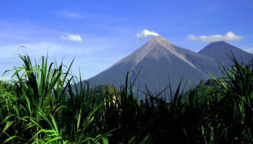
To the south of Antigua is Volcán de Agua (3,760 m), a regular, dormant cone visible from nearly any street downtown; to the southwest, the pair Acatenango (3,976 m) and Fuego (3,763 m), the latter nearly constantly active, with ash columns visible from the city and bigger eruptive phases every few years. In the center, 5a Avenida Norte, a street of cafés, jade jewelers and tour agencies, has the busiest pedestrian stretch in the city, from 8am to 8pm.
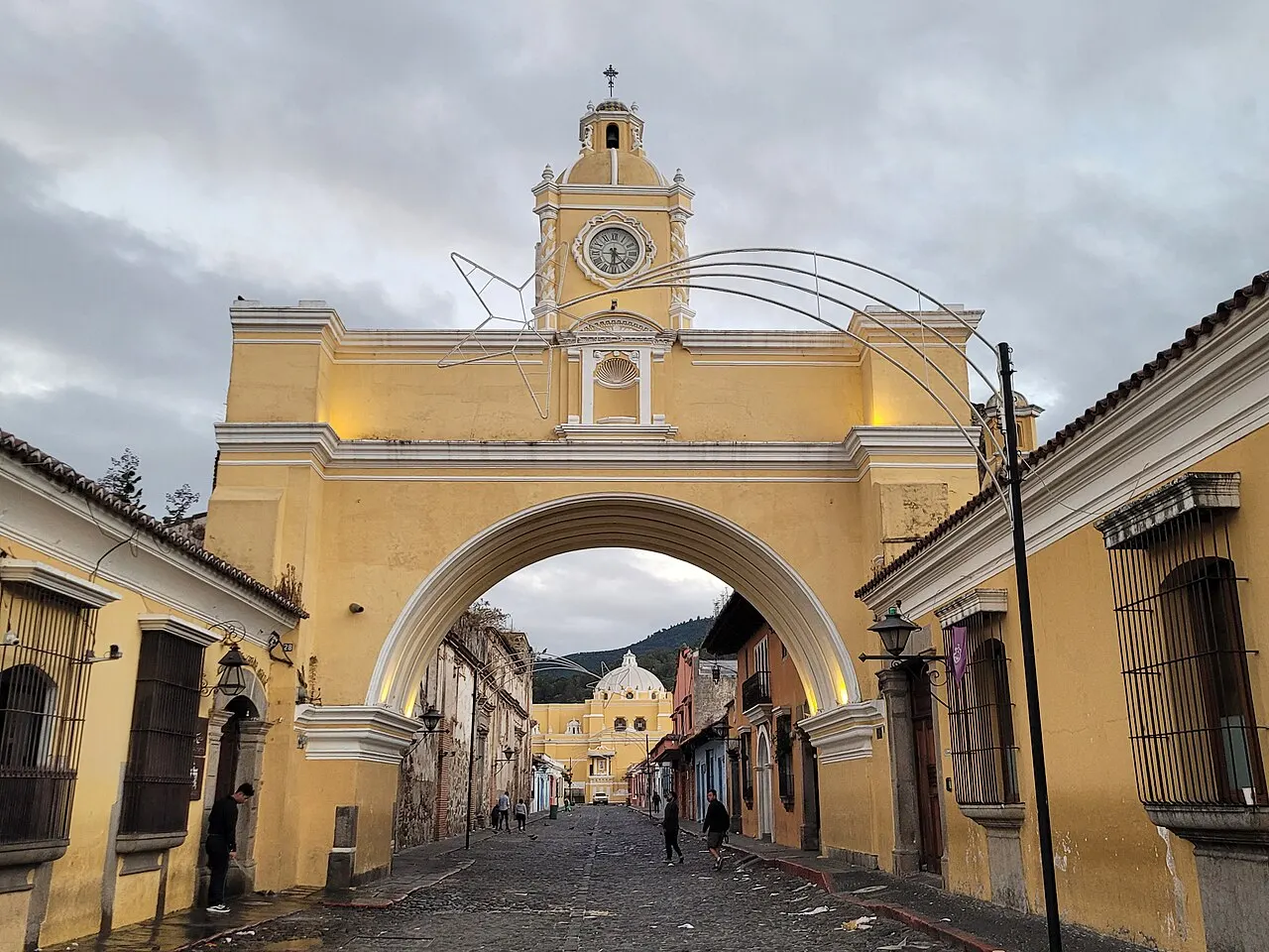
Arco de Santa Catalina
An elevated passage over 5a Avenida Norte, built in 1694 so the nuns of the Santa Catalina Mártir convent could cross the street unseen. The clock on top was added in the 19th century. It's the spot where Volcán de Agua appears framed in the background; go before 7am to photograph it without crowds.
Nuns crossed the street above, unseen, and the archway frames the volcano in the background; built in 1694; best before 7am.
Check access
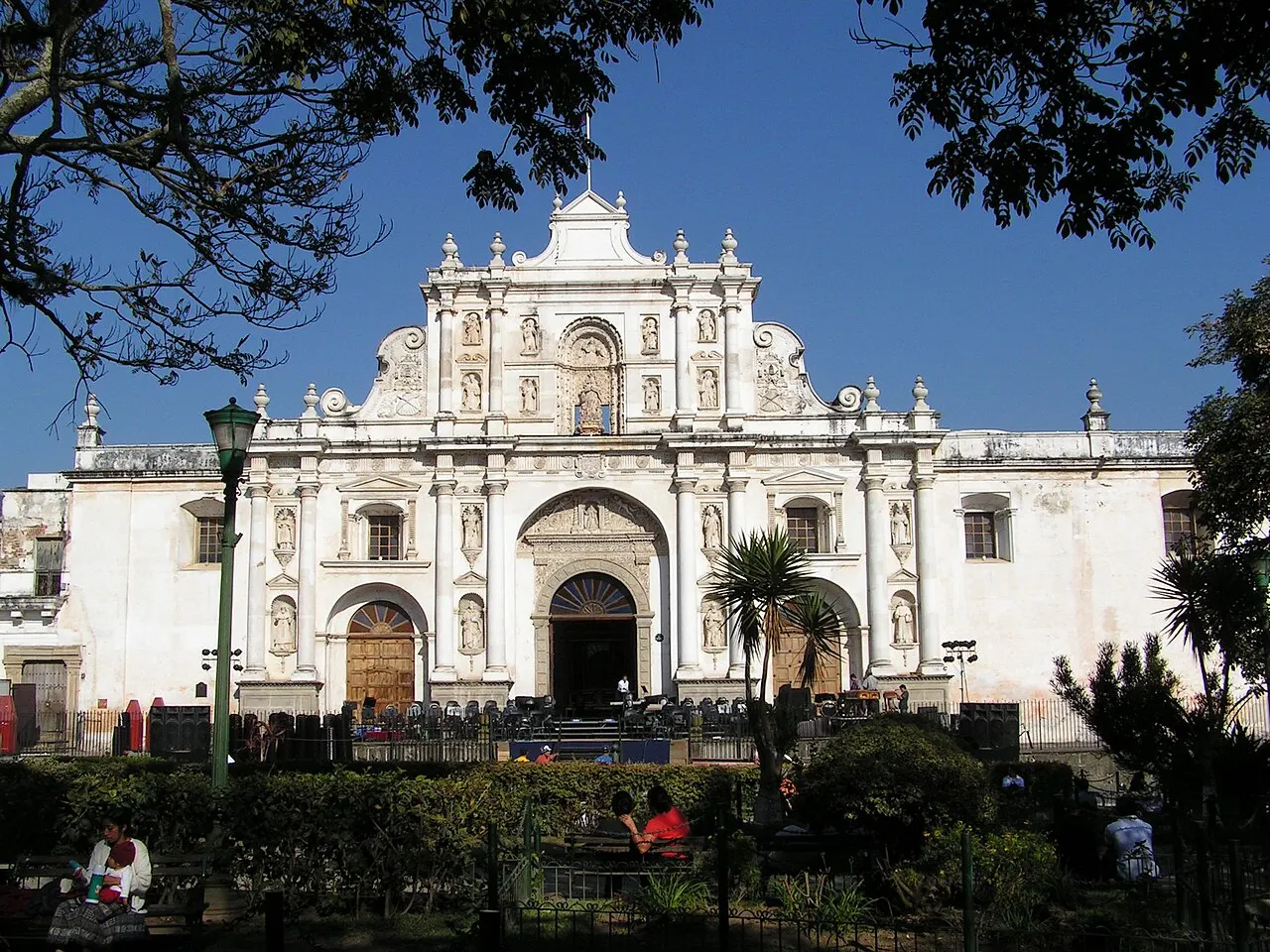
Catedral de San José and the ruins of Santiago
The white facade on the east side of the Parque Central belongs to the parish rebuilt in the 19th century. Behind it are the ruins of the 1680 cathedral, with fallen vaults open to the sky and the crypt holding Pedro de Alvarado and bishop Francisco Marroquín. Entry to the ruins is charged separately, about Q15–20.
The new façade hides fallen vaults open to the sky and a crypt with two colonial tombs; cathedral from 1680; about Q15 to Q20.
Check access

Convento de las Capuchinas
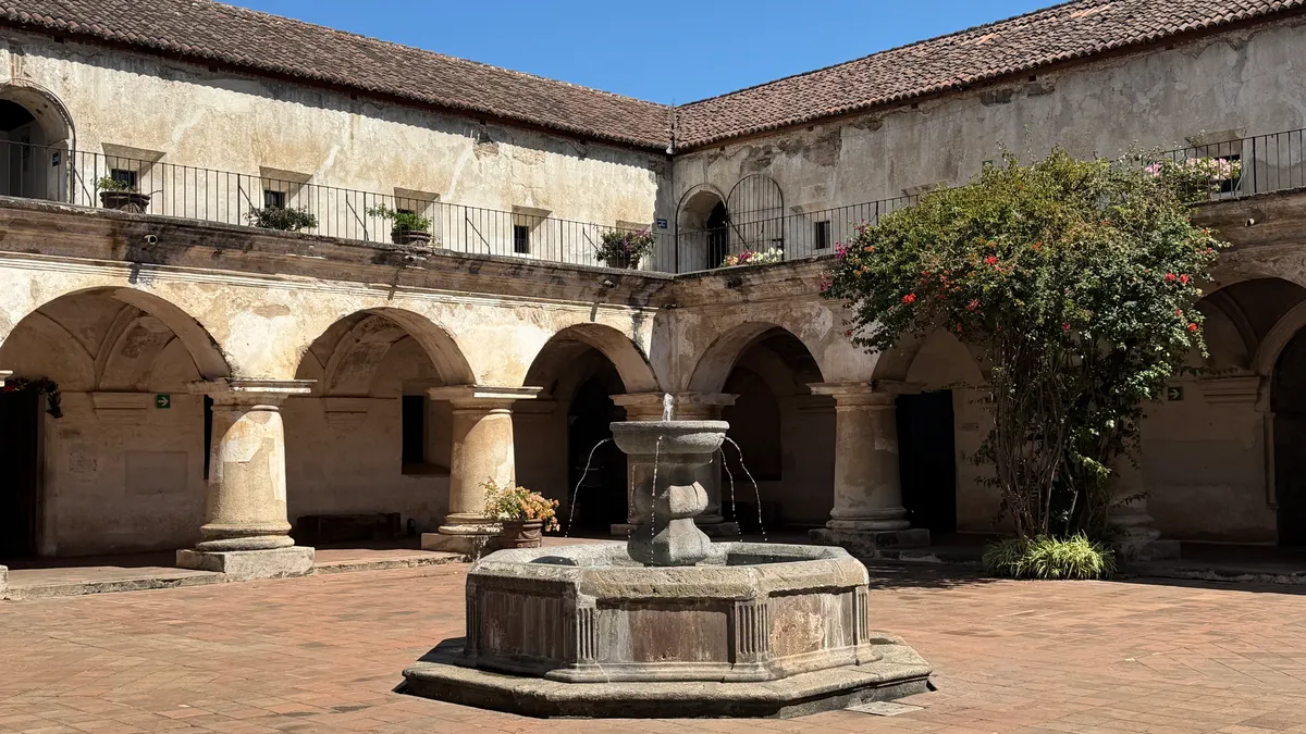
Founded in 1736, built by Diego de Porres, for an order that lived on alms and without servants. The rare piece is the Torre de Retiro: a cylinder with 18 cells around a circular courtyard, over a vaulted chamber. Entry about Q40 for foreigners.
The Torre de Retiro is a cylinder of 18 cells around a circular courtyard, above a vaulted chamber, in the 1736 convent built by Diego de Porres, with admission of about Q40 for foreigners.
Check access
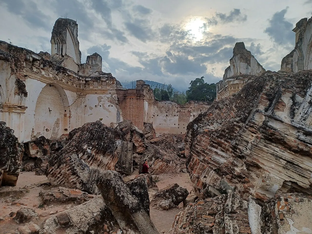
Ruins of La Recolección
Church and convent opened in 1717, shaken by the San Miguel earthquake the same year, rebuilt, struck again in 1751, and razed by the Santa Marta earthquakes in 1773. What's left is a field of car-sized vault blocks, left where they fell. It's the site that best shows the physical scale of the destruction the city never recovered from.
Huge blocks from the roof remain where they fell, and no other corner shows the scale of the damage so well; opened in 1717; razed in 1773.
Check access
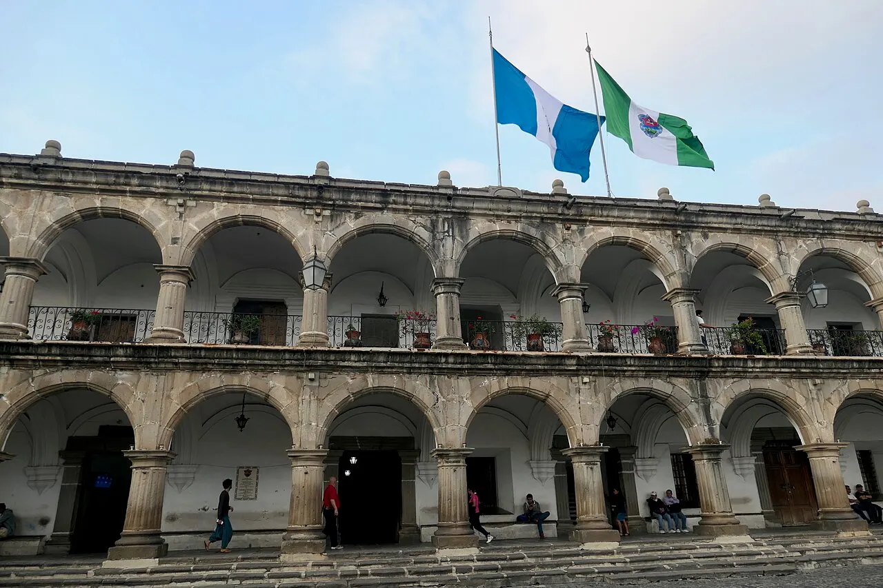
Palacio del Noble Ayuntamiento
On the north side of the square, exposed stone with a double arcade, finished around 1743. Inside are the Museo de Santiago, set in the old jail, and the Museo del Libro Antiguo, on the site of Pineda Ibarra's printing press, with a replica press and colonial editions.
Behind the double stone arcade there's a former jail and the house where the printing press operated; completed around 1743; Pineda Ibarra, a replica press.
Check access

La Merced
A 1767 church, yellow with white stucco relief foliage, designed by Juan de Dios Estrada: the most complete example of antigueño baroque, with deliberately low towers. In the ruined cloister next door sits a fountain about 27 m across. This is where the Jesus Nazareno procession sets out during Holy Week.
The church, built in 1767 to a design by Juan de Dios Estrada, is the most complete example of Antigua Baroque and has deliberately low towers, with a fountain about 27 m across in the cloister.
Check access

Casa Santo Domingo
The city's largest Dominican convent, converted into a hotel and cultural center. The museum circuit (archaeology, colonial art, goldwork, contemporary glass) includes crypts excavated in the 1990s with intact funerary murals. Open to non-guests, about Q40.
You can visit without staying there and see crypts with funerary painting still intact; the largest Dominican convent; about Q40, from the 1990s.
Check access
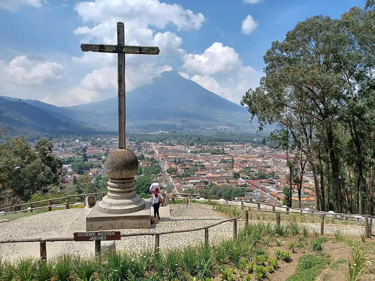
Cerro de la Cruz
A lookout about 15 minutes' climb up 1a Avenida Norte, with the whole grid framed below and Volcán de Agua behind it. Go in the morning, before clouds cover the volcano, and time your climb with the free escort of the tourist police (POLITUR).
The short climb frames the whole damero and the volcano, best in the morning, before the clouds, with a free escort; about 15 minutes; tourist police, POLITUR.
Check access
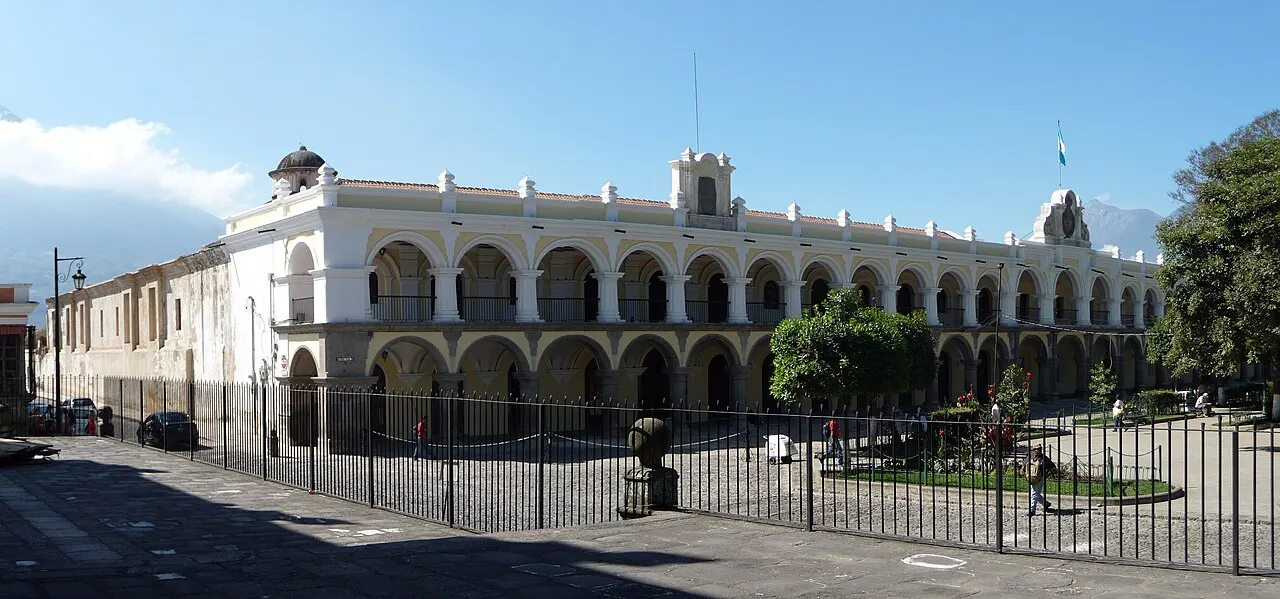
Palacio de los Capitanes Generales
Takes up the whole south side of the square, with two stacked arcades of 27 stone arches, and it was the seat of government for the entire Captaincy until the 1773 earthquakes, which moved the administration to the Valle de la Ermita in 1776. After a long restoration, finished in the 2010s, it now houses cultural offices, Inguat's office, and exhibition halls.
The 27 stone arches you already cross for free from the Parque Central; inside, after the restoration finished in the 2010s, what's there is the Inguat office and exhibition halls that change without notice.
Check access
Nilo’s itinerary
Start with the basic programme and choose extensions for the time you have.
Plan my days in the app ↗Day 1 · The colonial grid
6:30am: start under the Arco de Santa Catalina, and at 8am climb Cerro de la Cruz via 1a Avenida Norte, about 15 minutes, at the time of the POLITUR escort.
10am: head down to Parque Central to see the Fuente de las Sirenas (1739) and the facade of the Catedral de San José, and enter the ruins of the 1680 cathedral behind it, home to the crypt of Alvarado and Marroquín.
12:30pm: have the menú del día at a comedor on 6a Calle or near the market, Q35–60 with a drink, and order pepián or jocón.
2:30pm: visit the Museo de Santiago and the Museo del Libro Antiguo in the Ayuntamiento, then continue along Calle del Arco to the church of La Merced.
6pm: go back to Parque Central to eat tostadas and rellenitos standing up at the stalls that set up at dusk.
Day 2 · Convents, coffee, and chocolate
9am: start at the Convento de las Capuchinas, founded in 1736, and its Torre de Retiro; admission about Q40.
11am: walk ten minutes west to the ruins of La Recolección, where the vault blocks remain where they fell in the 1773 earthquakes.
1pm: have a light lunch and walk the museum circuit at Casa Santo Domingo, including the crypts with funerary murals.
3:30pm: take a tuk-tuk or taxi (10 minutes) to a coffee finca in Jocotenango for the tour of about 1 hour 30 minutes, from cherry to cup.
7pm: have dinner on 4a Calle Oriente and a beer near Santo Domingo. The town closes between midnight and 1am.





If you stay longer
Day 3 · The villages of the valley
8am: take a camioneta or tuk-tuk to San Antonio Aguas Calientes (about 7 km) to see backstrap-loom weaving and buy directly from the weavers.
10:30am: continue to Ciudad Vieja, site of the capital destroyed by the 1541 avalanche at the foot of Volcán de Agua, and visit the glazed-ceramics workshops.
12:30pm: go up to San Juan del Obispo to see the palace of Bishop Marroquín (1547) and buy candied fruit at the houses on the main street.
3pm: return via San Felipe de Jesús, with its white basilica and silver and jade workshops.
5pm: buy a box of dulces típicos on 4a Calle Oriente before the shops close and watch the sunset from 5a Avenida, with Agua in the background.
Food
 AI illustration
Pepián
A stew of chicken or beef in a broth thickened with toasted pumpkin and sesame seeds, tomato, and guaque and pasa chiles. The national dish, of Mayan and colonial roots, served with rice and tortillas. Q45–90 at a comedor.
 AI illustration
Antigua's dulces típicos
Convent-born sweets sold in small boxes: canillitas de leche, mazapán de pepitoria, figs and sweet potato in syrup, guava colochos, dulce de leche tablets. The traditional shops on 4a Calle Oriente have sold them since the 19th century; an assorted box runs Q40–80.
 AI illustration
Antigua coffee
Its own denomination: arabica grown between roughly 1,500 and 1,700 m in the valley's volcanic soil, with shade cover against occasional frost. Drip or espresso at cafés on 5a Avenida for Q20–35; the Jocotenango farms run bean-to-cup tours.
 AI illustration
Tamales and chuchitos
Corn dough steamed in banana or corn husk. The tamal colorado carries a tomato-based filling and the black one has chocolate and prune; both also show up at Christmas. The chuchito is the small, everyday version, Q5–10 on the street, topped with sauce and dry cheese.
 AI illustration
Rellenitos de plátano
Mashed plantain stuffed with sweetened black beans, fried, and rolled in sugar. Sold at the stalls of the Parque Central and Calzada Santa Lucía at dusk, about Q5 each.
 AI illustration
Park tostadas
A fried tortilla topped with guacamol, refried beans or tomato salsa, with parsley and grated cheese. The stalls on Parque Central sell them after 6pm, Q5–8 each; eat standing up and try three or four different kinds.
 AI illustration
Chiles rellenos and jocón
A bell pepper stuffed with ground meat and vegetables, dipped in beaten egg white and fried; jocón is the green chicken stew with tomatillo, cilantro, and scallion. Both show up on the comedor's menú del día, Q35–60 with a drink.
 AI illustration
Fiambre
A cold salad with dozens of ingredients (cold cuts, pickled vegetables, fish, cheeses, beets) assembled once a year, on November 1, to eat at the cemetery or at home. Every family has its own recipe, and almost no one serves it outside that day.
Day trips

Lake Atitlán (Panajachel)
The lake is about 78 km northwest, 2 hours 30 minutes to 3 hours by tourist shuttle (Q100–160 each way, with departures around 8am). It's a volcanic caldera about 340 m deep with twelve villages on its shore, and from Panajachel shared boats run to San Juan, San Pedro and Santiago Atitlán in 20 to 40 minutes.
Chichicastenango
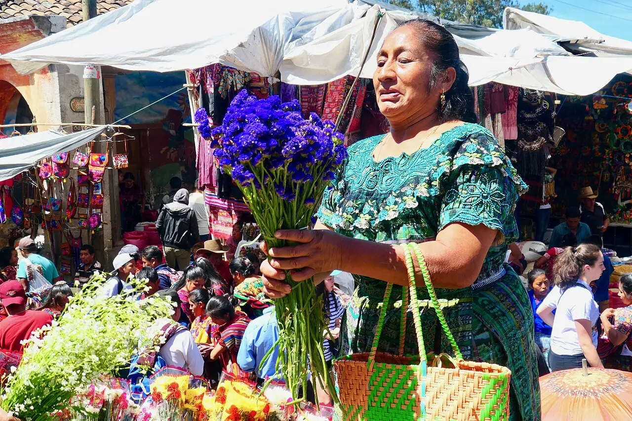
Chichicastenango is about 95 km away, around 3 hours by shuttle. On Thursdays and Sundays, the K'iche' market takes over the streets around the church of Santo Tomás, and on the church steps copal is burned in a K'iche' rite older than the building itself. Leave Antigua before 6am to arrive with the market in full swing and get back the same day.

Pacaya Volcano
The volcano is about 50 km southeast, 1 hour 30 minutes by van, and the guided hike to the lava fields takes 1 hour to 1 hour 30 minutes, with park admission around Q100 and a mandatory guide. Check the Insivumeh bulletin on the day, because access closes whenever activity picks up.
Where to begin
The colonial grid
6:30am: start under the Arco de Santa Catalina, and at 8am climb Cerro de la Cruz via 1a Avenida Norte, about 15 minutes, at the time of the POLITUR escort.
Convents, coffee, and chocolate
9am: start at the Convento de las Capuchinas, founded in 1736, and its Torre de Retiro; admission about Q40.
Money
The currency is the quetzal (GTQ, written Q), worth about 7.7 to the dollar and 1.4 to the Brazilian real in 2026; check the rate on the day, since these figures are approximate. Antigua is the most expensive city in Guatemala but still cheap for the region: coffee Q20–35, a menú del día at a comedor Q35–60 and a main at a tourist restaurant Q90–180. A Gallo beer runs Q20–30, and a tuk-tuk ride Q10–15. For a bed, count on Q90–160 in a hostel dorm, Q450–900 in a midrange hotel and from Q1,200 in a restored colonial house. Restaurants often add a 10% service charge to the bill, so check before leaving more, and leave the 10% if it isn't there. Cards work at hotels, restaurants, agencies and shops downtown, but markets, tuk-tuks, camionetas and street stalls take cash only. Carry Q20 and Q50 notes, because change for a Q200 is a constant problem at the stalls and holds up the line. ATMs (5B, Banrural, BAC) are near Parque Central and on Calzada Santa Lucía, charge Q35–45 per withdrawal and usually cap each one at Q2,000–3,000; use the ones inside bank branches, during the day.
Getting there and around
The airport is in the capital, 40 km away
International flights land at La Aurora (GUA), in Guatemala City, and from there to Antigua it's about 40 km by road on the CA-9, which takes 1 hour to 1 hour 30 minutes. On a Friday in the late afternoon, count on double that and try to arrive at another time. The most practical option is the shared door-to-door shuttle, timed to your flight, for Q80–150 per person; a taxi or private transfer costs Q250–400. The public camioneta, the chicken bus, leaves from Calzada Roosevelt for Q12–25, but it's no good if you're carrying a big suitcase. Uber works on both ends, with a base fare of Q7, about Q4.50 per km and a Q15 minimum in 2026, though drivers aren't always willing to come out to Antigua at night. Brazilians and most South Americans and Europeans enter without a visa and get a 90-day stamp. That period covers the whole CA-4 bloc (Guatemala, Honduras, El Salvador and Nicaragua), not 90 days per country, and at entry you may be asked for a passport valid for six months and proof of onward travel.
Antigua fits into 9 by 7 blocks, all on foot
There's no city bus line inside Antigua, and you won't miss one: the historic center is about nine by seven blocks and you can cross it on foot in 25 minutes. For longer distances, hail a tuk-tuk, Q10–15 per ride downtown and more to the villages, at the stands on Parque Central and Calzada Santa Lucía. Camionetas to Ciudad Vieja, San Antonio and Chimaltenango leave from the terminal next to the Mercado Municipal, also on Calzada Santa Lucía, for Q3–10, and depart when full, with no fixed schedule. To go farther, any agency on 5a and 6a avenidas sells tourist shuttles to Panajachel, Chichicastenango, Monterrico, Lanquín and Copán (Honduras), leaving early in the morning and costing Q100–350 depending on distance. The town has no traffic lights, the sidewalks are narrow and high, and the cobblestones rule out regular bikes, high heels and small-wheeled suitcases.
Safety
Antigua is one of the calmest cities in Guatemala, with the tourist police (POLITUR) present around the clock in the historic center. The risks are specific: phone and bag theft in crowded bars, at the market and at the camioneta terminal, muggings on isolated trails and hillsides, and people approaching anyone walking alone at night outside the lit damero. Don't go up to the Cerro de la Cruz lookout on your own: the tourist police run free escorts there, with times confirmed on the day at their office next to Parque Central. Climb volcanoes only with a registered guide and within the agreed hours, because Fuego's activity closes access without warning. At night, take a tuk-tuk or a ride-hailing app instead of crossing neighborhoods on foot, don't withdraw cash after dark and keep your phone out of your hand on the street. Don't drink tap water under any circumstances; ice at established restaurants, though, is usually made with treated water. Save these numbers before you need them: 110 (Policía Nacional Civil), 122 and 123 (fire department) and 1500 (PROATUR, tourist assistance, 24 hours, in Spanish and English).
Etiquette tips
Greet before you ask
Walking into a shop, a taxi or a comedor and going straight to your order comes across as rude. Say “buenos días” or “buenas tardes” first, and return the greeting when someone offers it to you on the street.
Address people as “usted”
“Tú” is barely used in Guatemala; among friends people say “vos”. With strangers, vendors, drivers and older people, “usted” is the norm and doesn't sound distant.
Don't step on the carpet
During Holy Week, the sawdust carpet is only walked on by the procession. Go around by the sidewalk even if it means three extra blocks, don't rest a tripod on the design, and don't cross the street between the carpet and the floats.
Ask before you photograph
Photographing women in Maya dress, children or vendors without asking is offensive and sometimes leads to a demand for money. Ask “¿puedo tomarle una foto?”, accept a no, and check for signs before using a camera inside a velación.
Haggle with moderation
At the Mercado de Artesanías, negotiating is part of the purchase: start by politely asking for a discount, without pushing hard. At cafés, restaurants, pharmacies, and shops the price is fixed, and haggling is rude.
Cover shoulders and knees in church and bring a jacket for the evening
Antigua's churches are in active use, and to attend a mass or velación you cover your shoulders and knees. Keep a jacket in your daypack year-round too, because the temperature drops from 26°C at 2pm to 12°C at 9pm.
Mistakes to avoid
Rolling suitcase and heels
Bringing a small-wheeled suitcase or heels. Every street in the center is uneven cobblestone, and plastic wheels jam and break within a few blocks. Go with a backpack or a suitcase with big wheels, and shoes with firm soles.
Day trip from the capital
Treating Antigua as a day trip from Guatemala City. It's 1 hour to 1 hour 30 minutes each way, and traffic can double that. The town is at its best early in the morning and at dusk, when the tour buses aren't there.
Volcano without a registered guide
Climbing Acatenango, Agua, or Pacaya without a registered guide and without checking the Insivumeh bulletin. In August 2026 the Fuego–Acatenango complex closed for days over eruptive activity. Acatenango only reopened on August 7.
Strong midday sun and cold nights without heating
Underestimating the sun and the night. At 1,530 m, the sun between 11am and 3pm burns fast, even at 24°C. The temperature drops to 10–12°C after 8pm in December and January, and colonial lodgings almost never have heating.
Holy Week without a reservation
Arriving for Holy Week without a reservation. Hotels sell out months in advance, and nightly rates go up two to three times. Entire streets close to cars, and the only way to get around town is on foot.
Useful phrases
Buenos días / Buenas tardes
Good morning / good afternoon. The phrase that opens any interaction, even with someone you're not going to buy anything from
¿Me regala la cuenta, por favor?
The check, please: “regalar” here is a Guatemalan courtesy phrase, not a request for something free
¿Cuánto le debo?
How much do I owe you? More polite than “cuánto cuesta” when paying a stall or a tuk-tuk
Va pues
Deal, agreed: a filler that closes any agreement, from price to schedule
¿Está muy picante?
Is it very spicy? Worth asking before the salsa; the local chiltepe is strong
Matyox
Thank you in Kaqchikel (pronounced “ma-TIÓCH”): used in Santa María de Jesús and San Antonio Aguas Calientes
Districts
Parque Central and the grid
The blocks around the square hold the cathedral, the Palacio de los Capitanes, the Ayuntamiento, and the 1739 Fuente de las Sirenas. It's where textile sellers, shoe-shiners, and tostada stalls set up in the late afternoon, and the zero point every street is numbered from.
Calle del Arco (5a Avenida Norte)
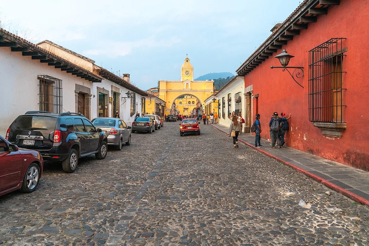
The stretch between the Parque Central and La Merced, with the Arco de Santa Catalina in the middle and Volcán de Agua framed to the south. A street of cafés, jade jewelers, and tour agencies; it's the busiest pedestrian stretch in the city, from 8am to 8pm.
La Merced and the north
Around the yellow church sit Spanish schools, mid-priced lodging, and smaller houses. It's the natural way out to Cerro de la Cruz and to the higher, quieter, cheaper neighborhoods of San Sebastián and La Candelaria.
La Concepción and Santo Domingo (east)
The strip between 1a and 3a avenidas, with the convents of Santa Clara and La Concepción, Casa Popenoe, and the Santo Domingo complex. It's the quietest part of downtown, with the priciest hotels and the dry bed of the Río Pensativo on the edge.
Calzada Santa Lucía and the market (west)
Calzada Santa Lucía runs north to south along the western edge of the damero and is the only road in town open to heavy traffic. Here you'll find the Mercado Municipal and the Mercado de Artesanías El Carmen, both open 6am to 5pm, and next to them the terminal where camionetas leave for the villages with no fixed schedule, whenever they fill up. Come in the morning, when the market is busy, because the avenue empties out at night.
San Felipe de Jesús and Jocotenango (north)
Two clusters 1.5–3 km from the square. San Felipe has the white basilica and silver and religious-craft workshops; Jocotenango has visitable coffee farms and the Centro Cultural La Azotea. Ten minutes by tuk-tuk.
San Juan del Obispo and Santa María de Jesús (south)
Villages on the slope of Volcán de Agua, 4 and 11 km away. San Juan holds Bishop Marroquín's 1547 palace and sells candied fruit right from people's homes; Santa María de Jesús is Kaqchikel-speaking and serves as the base for the Agua trail. It's several degrees cooler than the valley.
Ciudad Vieja and San Antonio Aguas Calientes (southwest)
Ciudad Vieja sits on the site of the capital destroyed by the 1541 avalanche and keeps glazed-pottery workshops. San Antonio, 3 km further, lives off backstrap-loom weaving and sells straight from the homes. Bus from Antigua, 20–30 min, Q3–5.
History
1524–1541 · Two capitals failed before this one
Pedro de Alvarado founds Santiago de Guatemala at Iximché (1524) and moves it to Almolonga (1527), at the foot of Volcán de Agua. On September 11, 1541, a torrent of water and mud comes down the mountain and wipes out the city, killing governor Beatriz de la Cueva.
1543 · Founding in the Panchoy Valley
On March 10, 1543, the town council sets up the capital 6 km away, in the Panchoy Valley, with a grid layout credited to engineer Juan Bautista Antonelli. The city goes on to govern from Chiapas to Costa Rica.
1660 · The first printing press
José de Pineda Ibarra sets up Central America's first printing press, one of the earliest in Spanish America. The workshop stood where the Palacio del Ayuntamiento stands today, which houses the Museo del Libro Antiguo.
1676 · University of San Carlos
Founded by royal decree in 1676 and confirmed by papal bull in 1687, it's the fourth university in the Americas. The original cloister is now the Museo de Arte Colonial, a block from the Parque Central.
18th c. · Baroque peak
The city reaches about 60,000 residents and more than thirty churches and convents, among the largest in Spanish America. Diego de Porres and other master builders create the antigueño baroque style: low towers, squat columns, walls up to two meters thick against earthquakes.
1717 and 1751 · The 1717 and 1751 earthquakes, before the final disaster
The San Miguel earthquake, on September 29, 1717, damages the newly opened church of La Recolección and nearly every building in town. The 1751 tremor repeats the damage, and the city rebuilds for the second time.
1773 · The Santa Marta earthquakes
On July 29, 1773, a series of earthquakes flattens the capital. What follows is a dispute between those who want to move to another valley and those who want to stay on the ruins.
1776 · The capital moves valleys
The Crown moves the seat of government to the Ermita Valley, where Nueva Guatemala de la Asunción, today's Guatemala City, is born. Santiago is officially abandoned and takes the name La Antigua Guatemala: the old Guatemala.
1832–1900 · Coffee and resettlement from 1832 onward
The government formally authorizes resettlement in 1832, and the city becomes the head town of the Sacatepéquez department. Justo Rufino Barrios's liberal reforms, starting in 1871, cover the volcanic slopes with coffee farms, and coffee money pays for restoring the colonial houses.

1944–1979 · A city protected by law
Declared a National Monument in 1944 and a Monument City of the Americas by the OAS in 1965, it enters the Unesco list in 1979. Decree 60-69 creates the CNPAG in 1969, the council that still approves facade colors and sign shapes today.
2022–2026 · Holy Week and volcano
Antigua's Holy Week joins Unesco's Intangible Cultural Heritage list in December 2022. In August 2026 an eruptive phase of Volcán de Fuego shuts the volcanic complex for days; Acatenango reopened on August 7, 2026. Check the bulletin before climbing.
Complete history
The 1541 avalanche and the refounding in the Panchoy Valley, in 1543
The city was born of a disaster. Pedro de Alvarado founded Santiago de Guatemala at Iximché in 1524 and moved it to Almolonga, at the foot of Volcán de Agua, in 1527. On September 11, 1541, after days of rain, an avalanche of water and mud came down the mountain and wiped out the capital; Beatriz de la Cueva, Alvarado's widow, who had governed Guatemala for only a few days, died in it. On March 10, 1543, the town council reestablished the city 6 km away, in the Panchoy Valley, on a grid of regular blocks credited to engineer Juan Bautista Antonelli, with north–south avenidas and east–west calles laid out from a central square.
Capital of everything between Chiapas and Costa Rica, for 233 years
For 233 years this was the capital of everything between Chiapas and Costa Rica. The Captaincy General governed from here, the Real Audiencia handed down rulings from here, and religious orders (Dominicans, Franciscans, Mercedarians, Jesuits, Capuchins, Poor Clares) raised more than thirty churches and convents in under two centuries, each with its cloister, garden, and cistern. In 1660 José de Pineda Ibarra set up the region's first printing press; in 1676 the University of San Carlos was born, the fourth in the Americas. At its height, in the 18th century, the city had about 60,000 residents, an aqueduct, public fountains, and a stucco and gilded-carving industry that exported across Central America.
The 1717 and 1751 earthquakes damaged the city twice
Earthquakes struck the city again and again throughout the 18th century. On September 29, 1717, the quake known as San Miguel brought down the newly opened Recolección church and left nearly every house cracked, and the one in 1751 repeated the damage. The master builders, led by Diego de Porres, answered with what is now called Antigua Baroque: very thick walls, low, wide towers, squat columns and stucco ornament instead of stone, all designed to sway without falling. The technique didn't survive the Santa Marta sequence, which flattened the city on July 29, 1773, and in 1776 the Crown moved the capital to the Valle de la Ermita, today Guatemala City.
The abandonment order, only partly followed
The order was to abandon everything, and the abandonment was partial. Families, artisans, and some orders stayed among the ruins without permission; resettlement was only made official in 1832, and shortly after the city became the head town of the Sacatepéquez department. What saved it economically was coffee: Justo Rufino Barrios's liberal reforms, starting in 1871, turned the volcanic slopes into farms, and coffee income paid to restore the colonial houses still standing. In this period foreigners began buying and restoring properties: American botanist Wilson Popenoe restored a 1636 house in the 1930s that's now visited as Casa Popenoe.
Preservation became law
Preservation became law in the 20th century. Antigua was declared a National Monument in 1944, a Monument City of the Americas by the OAS in 1965 and a UNESCO World Heritage Site in 1979; in 1969, decree 60-69 created the CNPAG, the council that approves wall colors, sign types and paving materials, and that bans neon, tall buildings and traffic lights. The magnitude 7.5 earthquake of February 4, 1976, forced a second wave of restoration. Today the economy rests on tourism, coffee and Spanish teaching, with dozens of schools open since the 1970s. The local Holy Week was added to UNESCO's Intangible Heritage list in December 2022, and the volcano still sets the calendar, because every eruptive phase of Fuego closes the trails in the region.
Geography and shape of the city
The valley and the three volcanoes
Antigua sits at the bottom of the Panchoy Valley, a volcanic basin at 1,530 m elevation, ringed by mountains on three sides. To the south is Volcán de Agua (3,760 m), a regular, dormant cone visible from nearly any street downtown; to the southwest, the pair Acatenango (3,976 m) and Fuego (3,763 m), the latter nearly constantly active, with ash columns visible from the city and bigger eruptive phases every few years. To the north, Cerro de la Cruz closes the valley and serves as a lookout.
Climate and elevation
Elevation, not latitude, explains the climate: highs between 24°C and 27°C year-round and lows of 10°C to 15°C, with a dry season from November to April and late-afternoon rain from May to October.
The grid and the cobblestone streets
The street plan is the classic Spanish damero, with avenidas running north-south and calles east-west, numbered from Parque Central and given the suffix Norte, Sur, Oriente or Poniente depending on the side: 5a Avenida Norte is the street with the Arch, 4a Calle Oriente the one lined with restaurant tables. The streets are cobblestone, buildings rarely go above two stories because of the seismic risk and the CNPAG rules, and heavy traffic is pushed out to Calzada Santa Lucía, on the western edge, where the market and the camioneta terminal are. The Río Pensativo, nearly always dry, runs along the eastern edge and drains into the Guacalate.
The streets form a grid of nine by seven blocks: it's easy to get lost on the first day and never again after that.
The volcano appears at the end of almost every avenue, because the streets were laid out in its direction.
Culture
Three economies in the same block
Three overlapping cultural trades support Antigua's economy. The first is Spanish teaching: since the 1970s, dozens of schools have offered one-on-one classes with homestays, and the model (four to five hours a day, one teacher per student) was born here and copied across the rest of Latin America. The second is craftwork: workshops cutting jadeite from the Motagua valley, silverwork in San Felipe de Jesús, glazed pottery in Ciudad Vieja, and backstrap-loom weaving in San Antonio Aguas Calientes, where an elaborate huipil takes months. The third is coffee, with farms in the valley that welcome visitors, roast on site and sell beans under the Genuine Antigua Coffee designation.
Holy Week brotherhoods, centuries-old neighborhood associations
The hermandades and cofradías that organize the processions are centuries-old neighborhood associations, with waiting lists to carry the floats and a shift system that decides who carries each stretch of street; carrying is a family inheritance and a commitment, not casual volunteering. Outside Holy Week, the music you hear downtown is the double-keyboard marimba, the national instrument, which plays in Parque Central on Sundays and holidays and at almost every wedding. The highlands around town also serve as a backdrop for Guatemalan cinema: Jayro Bustamante's generation (Ixcanul, 2015; La Llorona, 2019) films there, and galleries such as La Antigua Galería de Arte and the spaces at Santo Domingo show contemporary Guatemalan painting year-round.
Bars that close at midnight and streets without neon
Nights are short by rule and by habit. Bars and restaurants cluster on 4a Calle Oriente, on 5a Avenida, and around Santo Domingo, with small-scale live music; most close between midnight and 1am. The city stays dark because the CNPAG bans lit signs, neon, and tall street lamps: public lighting is yellow and low, and international chains operate behind colonial facades with no large logos. The same rules explain the lack of traffic lights in the historic center and the deliberate upkeep of the ruined churches as ruins, with no rebuilding.
Each stretch of street carpeted with alfombras has belonged to the same family for generations, and anyone who offers to help usually finds that out on the spot.
Festivals and events

Lent and Holy Week
Six weeks of vigils and processions, from late February or early March through Easter (March 28 in 2027). Neighborhoods spend the night building carpets of dyed sawdust, flowers, and pine needles that the floats destroy in minutes; male bearers wear purple robes (cucuruchos), female bearers wear black. A Unesco Intangible Heritage listing since December 2022. Book lodging months ahead.

Quema del Diablo
December 7, at exactly 6pm: every house burns trash and a devil figure on the sidewalk to clean the home before the Feast of the Immaculate Conception. Thick smoke for an hour; anyone with asthma should stay indoors.
 AI illustration
Día de Todos los Santos
November 1: fiambre with the family and barriletes, giant tissue-paper kites up to 20 m across, raised in the cemeteries of Sumpango and Santiago Sacatepéquez, 10–20 km from Antigua. Leave before 8am, because the road jams up.
 AI illustration
Santiago Apóstol
July 25, the city's patron saint feast: mass at the cathedral, marimba in the Parque Central, a fair, and fireworks. Much smaller and more local than Holy Week, with no impact on prices.
 AI illustration
Posadas and Christmas
From December 16 to 24, nightly processions with images of Mary and Joseph asking for shelter house to house, with fireworks, hot ponche, and tamales at the end. On the night of the 24th the whole city sets off fireworks at midnight.
Books and films
Leyendas de Guatemala (1930), Miguel Ángel Asturias
The first book by Miguel Ángel Asturias, winner of the 1967 Nobel Prize in Literature, written in Paris from memories of home. It weaves together Maya myth and colonial heritage and treats the old city and its ruins as a character, good reading before you walk among the fallen convents.
Recordación Florida (1690), Francisco Antonio de Fuentes y Guzmán
A chronicle of the kingdom of Guatemala written by a criollo while Santiago was still the capital, describing streets, trades, supplies, and the life of the religious orders. It's a portrait of the city the 1773 earthquakes brought to a close.
Ixcanul (2015), Jayro Bustamante
Jayro Bustamante's feature film in Kaqchikel, shot on the slopes of a volcano a few dozen kilometers from here. It shows life in the highland villages that supply Antigua's markets and coffee fincas, the part of the local economy you don't see in the restored center.
Frequently asked questions
Antigua: Can you wheel a small-wheeled suitcase around downtown?
With small wheels, no: every street in the center is rounded, uneven cobblestone, and plastic wheels jam and break within a few blocks. Prefer a backpack or a large-wheeled suitcase.
Antigua: How do you get from the capital's airport to the city?
The most practical option is the shared door-to-door shuttle, timed to your flight, for Q80 to 150 per person; a taxi or private transfer costs Q250 to 400.
Antigua: How long does it take to get to Lake Atitlán?
The lake is about 78 km northwest, 2 hours 30 minutes to 3 hours by tourist shuttle (Q100 to 160 each way, with departures around 8am).
Antigua: What's the currency, and how much is the quetzal worth?
The currency is the quetzal (GTQ, written Q), worth about 7.7 to the dollar and 1.4 to the Brazilian real in 2026; check the rate on the day, since these figures are approximate.
Antigua: What's the climate like throughout the year?
At 1,530 m, the thermometer barely moves, between about 10°C and 27°C all year, and what changes is the rain: the dry season runs from November to April, and from May to October there's an almost daily downpour between 3pm and 7pm.