Peru
Cusco
Inca walls, Andean markets and the road to the ruins
Days Start with the basic programme and choose extensions for the time you have.
How the guide reaches this number
Cusco doesn't suit anyone who wants to arrive and pack in tours back to back, because at 3,399 m you move more slowly than you plan, and anyone who ignores that loses the afternoon to a headache. It's also not a nightlife destination: nightlife comes down to the bars on the blocks around the Plaza de Armas, aimed at those just passing through. With just one day, leave Machu Picchu out, because it takes the whole day, and start with the cathedral in the morning. Walk along Calle Hatunrumiyoc to San Blas at noon, reach the Qoricancha in the late afternoon, when the light hits the curved wall, and have anticuchos for dinner at Plaza San Francisco after 7pm. In the Plaza de Armas, restaurant and tour touts approach passersby nonstop, and much of the “Andean tradition” sold there was put together for newcomers. The historic center has emptied of residents and turned into hotels and agencies, and the city's life goes on in the San Pedro and Santiago neighborhoods and on the hillsides above San Blas.
4–5
When April–May and September–October: dry, without the June–August peak; February tends to be the rainiest month of the year
How the guide reaches this number
Cusco has two seasons, and what separates them is rain, because daytime temperature changes little through the year. The dry season runs from April to October, with steady sun between 18 °C and 21 °C during the day and nights of 0 °C to 5 °C; in June and July lows reach −2 °C, and since unheated guesthouses are the rule, pack a thermal layer. The rainy season runs from November to March, with similar highs, lows of 6 °C to 9 °C and late-afternoon downpours, and January and February are the cloudiest months. In February the Inca Trail closes entirely for maintenance, and in the rain landslides can cut the railway. Peak crowds come in June, July and August, topping out in the week of Inti Raymi, when hotel prices double. The best windows are April and May, with the valley still green, and September and October are also good, at lower prices. In any month the UV index tops 11 at midday, so bring sunscreen, a hat and water even on a cold day.
Per person/day S/120–200 backpacking, S/350–600 mid-range comfort, not counting Machu Picchu entry and train
How the guide reaches this number
Per person per day: accommodation, meals, urban transport, visits and a small allowance for extras. Flights excluded; larger purchases vary. Editorial estimate, not a quote.
 What Nilo thinks
Stay four days: two in the city, one in the Sacred Valley, sleeping in Ollantaytambo, and one at Machu Picchu, with a fifth as slack in case of a road blockade. Cusco doesn't suit anyone who wants to arrive and pack in tours back to back, because at 3,399 m you move more slowly than you plan, and anyone who ignores that loses the afternoon to a headache. It's also not a nightlife destination: nightlife comes down to the bars on the blocks around the Plaza de Armas, aimed at those just passing through. With just one day, leave Machu Picchu out, because it takes the whole day, and start with the cathedral in the morning. Walk along Calle Hatunrumiyoc to San Blas at noon, reach the Qoricancha in the late afternoon, when the light hits the curved wall, and have anticuchos for dinner at Plaza San Francisco after 7pm. In the Plaza de Armas, restaurant and tour touts approach passersby nonstop, and much of the “Andean tradition” sold there was put together for newcomers. The historic center has emptied of residents and turned into hotels and agencies, and the city's life goes on in the San Pedro and Santiago neighborhoods and on the hillsides above San Blas.In Cusco, the colonial houses of the center rest on Inca walls of stone fitted without mortar, older than the Spanish conquest, which still serve as walls, complete with doors and doorbells. From here, at 3,399 m, the Incas ruled a territory that stretched from present-day Colombia to Chile. Today this is the starting point for the Sacred Valley and Machu Picchu, 75 km away. In the city, see the Twelve-Angled Stone on Calle Hatunrumiyoc, the curved wall of the Qoricancha in the late afternoon and the three zigzag walls of Saqsaywaman. Eat choclo with fresh cheese on the street and have lunch for S/10 at San Pedro market. At night, order anticuchos in Plaza San Francisco. Walk slowly for the first two days, because the lack of oxygen makes any hill hard going. Come in April or May, with the dry season starting and the valley still green.
Quick facts
- Population
- about 497,000 residents in the urban area, including Santiago, Wanchaq, San Sebastián, and San Jerónimo (INEI projection, 2025)
- Founded
- Continuous occupation since about 1000 BC; rebuilt in stone by Pachacútec starting in 1438; Spanish refounding on March 23, 1534
- Country and region
- Peru, South America; capital of the Cusco department, at 3,399 m, in the Huatanay valley
- Language
- Spanish and Cusco-Collao Quechua, co-official in the region; Quechua is the first language across much of the countryside
- Currency
- Sol (PEN, written S/); around 3.4 per dollar and 0.65 per Brazilian real (Sept. 2026)
- Time zone
- UTC−5 year-round; Peru does not observe daylight saving time
- Best time to visit
- April–May and September–October: dry, without the June–August peak; February tends to be the rainiest month of the year
- Average daily cost
- S/120–200 backpacking, S/350–600 mid-range comfort, not counting Machu Picchu entry and train
When to go
April–May and September–October: dry, without the June–August peak; February tends to be the rainiest month of the year
How the year changes
Cusco has two seasons, and what separates them is rain, because daytime temperature changes little through the year. The dry season runs from April to October, with steady sun between 18 °C and 21 °C during the day and nights of 0 °C to 5 °C; in June and July lows reach −2 °C, and since unheated guesthouses are the rule, pack a thermal layer. The rainy season runs from November to March, with similar highs, lows of 6 °C to 9 °C and late-afternoon downpours, and January and February are the cloudiest months. In February the Inca Trail closes entirely for maintenance, and in the rain landslides can cut the railway. Peak crowds come in June, July and August, topping out in the week of Inti Raymi, when hotel prices double. The best windows are April and May, with the valley still green, and September and October are also good, at lower prices. In any month the UV index tops 11 at midday, so bring sunscreen, a hat and water even on a cold day.
Nilo's tips
Spend the first day only in the flat center and leave the 4,000 m for the end
Arriving from Lima, you go from sea level to 3,399 m in a 1 hour 20 minute flight, and soroche usually shows up in the first 24 to 48 hours. So spend the first day on the flat blocks around the Plaza de Armas, with the cathedral and the Qoricancha, and leave the ruins above the city for the second. If the headache doesn't go away with rest, water and coca tea, go down to the Sacred Valley, 600 m lower, on the vans that leave from Calle Pavitos for S/10–15: in Urubamba or Ollantaytambo sleep comes easier. Leave Vinicunca and Lake Humantay, at 4,000 or 5,000 m, for the end of the trip.
Buy the Boleto at the Cosituc counter, on arrival day
Bought on arrival day, the ticket is ready for the second day, when the ruins begin, because the first day is for acclimatizing and needs no ticket at all. The counter is on Avenida El Sol, and the ticket is issued in your name, with ID, valid for 10 days from purchase. The Integral costs S/130 for foreigners and covers 16 sites, among them Saqsaywaman, Q'enqo, Puka Pukara, Tambomachay, Pisac and Ollantaytambo, so it already pays for itself if you're going to the Sacred Valley. The partial versions by circuit, at S/70, pay off if you're only doing the upper circuit.
Take a taxi to Tambomachay and walk 8 km down
Since the path only goes downhill, you can see the ruins above the city without facing an uphill climb at altitude. It's about 8 km from Tambomachay down to Saqsaywaman, passing the ruins along the way, all covered by the same Boleto Turístico.
Go to San Pedro market 7-9am, with small bills
Between 7am and 9am the market is free of lines and crowding, and there you only pay in cash, in small bills: the S/100 note is often refused. The Mercado Central de San Pedro opens around 6am and empties out in the late afternoon; early on, fruit juice goes for S/6–10, and at lunchtime the stalls serve a full meal for S/10. Break the big bill at your hotel before heading down and, since each ATM withdrawal charges a fee of S/15 to S/25, take out the cash for your days in the city all at once. Amid the crowding at the stalls, wear your backpack in front of your body, because theft is the real risk of the place.
Machu Picchu: sleep in Ollantaytambo the night before
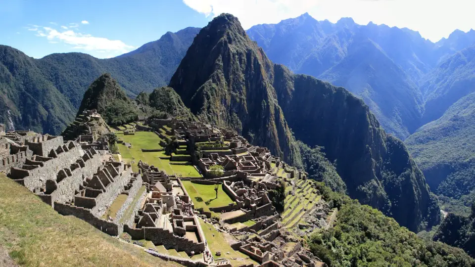
The same-day round trip leaving Cusco at 4am works, but it gets you back late at night and burns two days of energy. Do the Sacred Valley the day before and sleep in Ollantaytambo. Catch the morning train from there: 1 hour 30 minutes to Aguas Calientes, plus 30 minutes by bus to the entrance, about $12 each way. Buy the entry ticket ahead at tuboleto.cultura.pe, from S/152, plus the S/11 Sernanp fee. Check the circuit and time slot printed on it: it's a one-way route, with no re-entry.
A red plastic bag at the door: fresh chicha inside
That, or a flower on a stick, is how a neighborhood chichería signals that it has fresh chicha de jora that day, and anyone who doesn't know it mistakes the bag for a construction sign. Go during the day, because the glass is big, and order the frutillada, with crushed strawberry, if you want the sweet version. At night, neighborhood food changes address: after 7pm, the stalls at Plaza San Francisco serve anticuchos with potato and corn, the locals' dinner.
Explore the map

© OpenStreetMap · OpenFreeMap · © OpenMapTiles
Explore the map, read about the other places and plan your travel days in the app.
Open the appWhat to see
Cusco: The valley and the shape of the puma
Cusco's climate is tropical highland: strong sun and dry air from April to October, afternoon rain from November to March, cold nights year-round, and a daily temperature swing that can top 20°C. The city that visitors see fits into the ten blocks around the Plaza de Armas, where the cathedral, La Compañía, the agencies, the restaurants and nearly every hotel are.
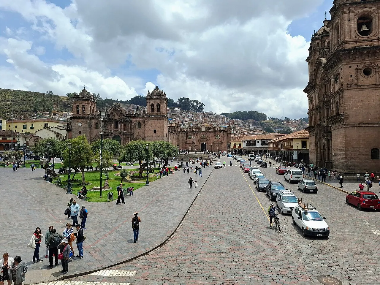
Cusco Cathedral
Built between 1560 and 1654 over the Kiswarkancha palace, with blocks taken from Saqsaywaman. It houses the darkened Christ of the Señor de los Temblores and Marcos Zapata's Last Supper, in which the central dish is a roasted cuy.
The church was built from 1560 to 1654 on top of the Kiswarkancha palace, with stones brought from Saqsaywaman; it holds the Señor de los Temblores, and Marcos Zapata's Last Supper places a roasted cuy at the center of the table.
Check access
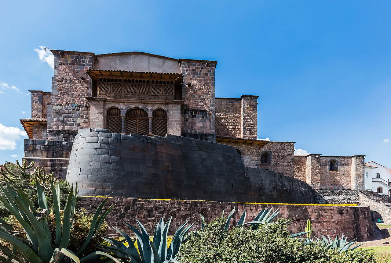
Qoricancha and the Convent of Santo Domingo
The Inca sun temple had its walls lined with gold plates. In 1533, Pizarro's envoys tore off much of it for Atahualpa's ransom, and what was left was looted after the Spanish entry, in November. The Dominicans built the convent on top; the curved fitted-stone wall survived the earthquakes of 1650 and 1950, and the colonial church did not.
The curved fitted-stone wall of the Inca sun temple stayed standing through the earthquakes of 1650 and 1950, and the colonial church the Dominicans built on top did not. The gold plates that lined the walls came off in 1533, much of it for Atahualpa's ransom and the rest in the looting that followed the Spanish entry.
Check access

Saqsaywaman
A megalithic complex on the hill to the north, with three zigzagging walls and blocks over 100 tons, begun over Killke structures and expanded from the 1440s. It was the base for the 1536 siege and later a quarry for the colonial churches; today it hosts the Inti Raymi on June 24.
The hill's three zigzagging walls use blocks that top 100 tons, and today they host the Inti Raymi on June 24.
Check access
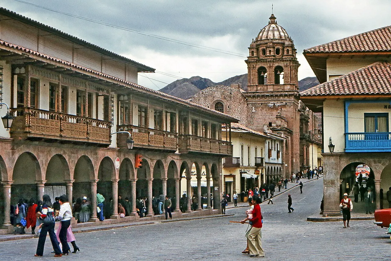
Plaza de Armas (Haukaypata)
The Inca ceremonial plaza where the roads of the four suyus met, now with half of its original area built over. It was covered with sand brought from the coast and was the site of the executions of Túpac Amaru I, in 1572, and Túpac Amaru II, in 1781.
The square marked the meeting point of the roads of the four suyus; today it holds only half its original area, and it was the stage for the execution of Túpac Amaru I in 1572 and of Túpac Amaru II in 1781.
Check access

Q'enqo, Puka Pukara, and Tambomachay
Three sites on the road above Saqsaywaman, covered by the same Boleto Turístico: a rock outcrop carved with channels and an altar, a red-stone checkpoint, and a spring complex with water still flowing after five centuries.
The trio on the road up from Saqsaywaman is covered by the same Boleto Turístico: a rock carved with channels, a red-stone outpost and springs with water still flowing after five centuries, named Q'enqo, Puka Pukara and Tambomachay.
Check access

Calle Hatunrumiyoc and the Twelve-Angled Stone
The wall of Inca Roca's palace, today the Archbishop's Palace and Museum of Religious Art, with a twelve-cornered block fitted without mortar. Touching the stone is forbidden; there's a guard on site.
A block with twelve corners fits without mortar. Touching the stone is forbidden, and there's a guard on site.
Check access

San Blas neighborhood and church
Cusco's oldest adobe church, from 1563, houses a carved cedar pulpit from the 17th century, attributed to Juan Tomás Tuyru Túpac. Around it are the sculpture workshops of the Mérida and Olave families and the square where you sit to look out over the city.
The 1563 adobe church holds a carved cedar pulpit from the 1600s, credited to Juan Tomás Tuyru Túpac, and around it are the Mérida and Olave carving workshops and the square where you can sit and take in the view.
Check access
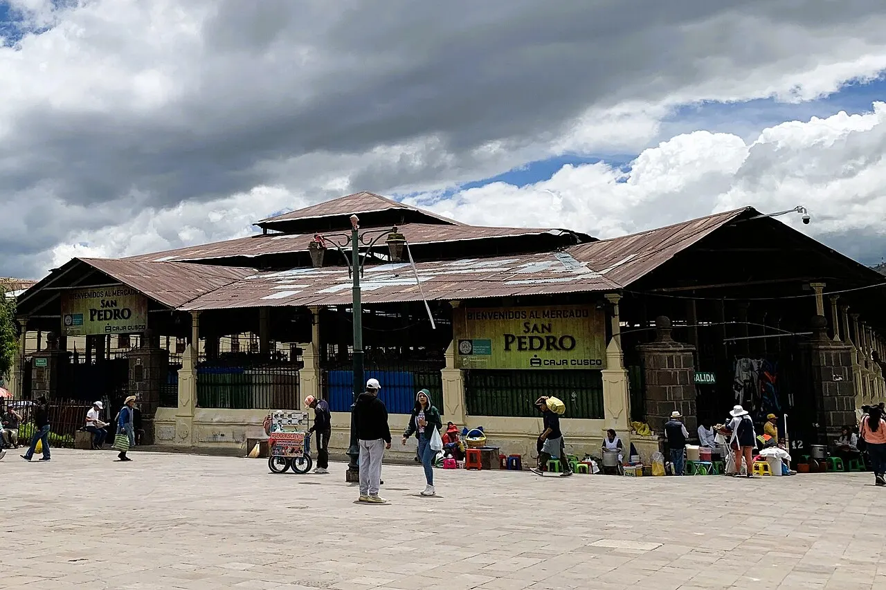
San Pedro Central Market
Opened in 1925, with a metal structure popularly attributed to Gustave Eiffel's workshop, an attribution without documentary confirmation. It sells herbs, cheeses, fruit juices for S/6–10, and cheap set lunches; it opens around 6am and empties out in the late afternoon.
Opened in 1925 with a metal frame, the market has a popular attribution to Eiffel's workshop with no documentary confirmation at all. It sells herbs, cheeses and juices at S/6 to 10 and opens around 6am.
Check access
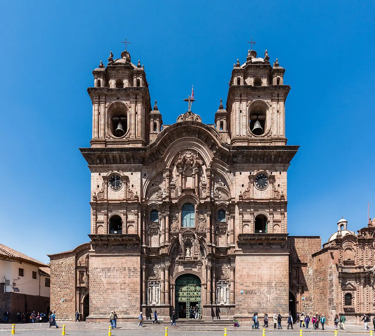
Church of the Compañía de Jesús
Built by the Jesuits over the Amarukancha, palace of Huayna Cápac, rebuilt after 1650 and completed in 1668. The façade turned out so grand that the archbishop appealed to Rome claiming it outshone the cathedral; the papal reply arrived after the work was finished.
Check access
Nilo’s itinerary
Start with the basic programme and choose extensions for the time you have.
Plan my days in the app ↗Day 1 · Acclimatization: the colonial center over the Inca one
Arrive, drop your bags, and don't sleep the whole afternoon: walk slowly to the Plaza de Armas and sit down for a coca-leaf tea.
Go into the cathedral (1560–1654) and look for Marcos Zapata's Last Supper, with cuy as the central dish, and the Señor de los Temblores.
Walk down Avenida El Sol to the Qoricancha in the late afternoon, when the light hits the curved fitted-stone wall.
Buy the Boleto Turístico Integral (S/130) at the Cosituc office, on Avenida El Sol, to start using tomorrow.
Have an early, light dinner, no alcohol: the first night at 3,399 m is usually the worst.
Day 2 · The stones above the city and the artisans' neighborhood
Take a taxi to Tambomachay and walk down past Puka Pukara, Q'enqo and Saqsaywaman.
Set aside at least an hour at Saqsaywaman for the three zigzagging walls and the blocks over 100 tons.
Come back down the San Cristóbal slope and into San Blas: a 1563 church with a cedar pulpit and the sculpture workshops around it.
Pass by Calle Hatunrumiyoc to see the Twelve-Angled Stone, without touching it, then follow Calle Loreto to the square.
Have anticuchos with ponche for dinner at the stalls around Plaza San Francisco.
Day 3 · The Sacred Valley down to Ollantaytambo, where you spend the night
Leave at 7am for Chinchero (30 km) and visit a weavers' association to see cochineal dyeing.
Continue to Moray, with its concentric circular terraces, and to the Maras salt pans, in use since before the Incas.
Have lunch in Urubamba, 600 m lower and much warmer than Cusco.
Finish in Ollantaytambo: the unfinished sun temple up top and the only Inca urban grid still inhabited.
Sleep in Ollantaytambo: the morning train to Machu Picchu leaves from there, and the drive back to Cusco takes 2 hours.
Day 4 · Machu Picchu
Day trip
75 km as the crow flies, and a full day in practice: 2 hours by car to Ollantaytambo, 1 hour 30 minutes by train to Aguas Calientes, 30 minutes by bus to the entrance. The time slot and circuit are printed on the ticket, bought in advance. A same-day round trip exists, but it's an exhausting journey starting before dawn.


If you stay longer
Day 5 · Free day
Free day: use it to rest, go back to the place you liked most or cover a setback.
Food
 AI illustration
Chiriuchu
The Corpus Christi dish, served cold: roasted cuy, chicken, dried meat, fish roe in an omelet, cochayuyo seaweed, cheese, rocoto pepper, and a corn fritter. Eaten by hand, once a year, at the stalls around the square.
 AI illustration
Cuy al horno
Whole roasted guinea pig, raised in Peru for millennia and reserved for festivals and Sundays. Tipón, 25 km to the southeast, has become the go-to address; expect to pay S/45–80 per animal.
 AI illustration
Adobo cusqueño
Pork stew marinated in chicha de jora with ají and cumin, cooked overnight and eaten in the morning, especially on Sundays. It's the local answer to the night before, served with bread at neighborhood kiosks.
 AI illustration
Chicharrón con mote
Pork cooked in its own fat, with mote corn, potato, and fried mint. Saylla, 12 km to the southeast, bills itself as the chicharrón capital and serves it from breakfast on.
 AI illustration
Choclo con queso
The giant white corn from the Urubamba valley, boiled and sold on the street with a piece of fresh cheese. Costs S/3–6, eaten standing up, and is the city's most common snack.
 AI illustration
Chicha de jora and frutillada
Lightly fermented beer made from sprouted corn, served in a large glass at neighborhood chicherías. The frutillada adds crushed strawberry and is sweeter.
 AI illustration
Pan chuta from Oropesa
A round sweet bread, up to 50 cm across, baked in a wood-fired oven in Oropesa, 25 km to the southeast, sold from baskets on the streets and on buses. It keeps for days and is the standard gift for whoever's staying home.
 AI illustration
Anticuchos and ponche at night
Grilled beef-heart skewers over charcoal, with potato and a slice of corn, sold from 7pm around Plaza San Francisco. They come with ponche de habas or cinnamon tea from the same corners.
Where to eat
- Pachapapa · San Blas · $$
Cusco cooking from a clay oven, with cuy al horno and suckling pig.
Source · 2026-09-27
- Chicha · Plaza Regocijo · $$$
Regional Peruvian dishes in Gastón Acurio’s version, on the second floor of number 261. Book ahead.
Source · 2026-09-27
- Cicciolina · Calle Triunfo · $$$
Italian cooking with Andean ingredients, on the street that climbs from the Plaza de Armas to San Blas.
Source · 2026-09-27
- Wanchaq and Molino · $
Cheap lunch off the tourist circuit, at the neighborhood markets of Wanchaq and Molino.
- MIL · Moray, in the Sacred Valley · $$$
An eight-course menu with ingredients from each altitude, by Virgilio Martínez and Pía León, No. 49 on Latin America’s 50 Best 2025. Book well ahead and pair it with the Sacred Valley day.
Source · 2026-09-27
$: up to S/30 per meal · $$: S/30–80 per main course · $$$: over S/80 per main course, or a tasting menu · 2026-09-27
Day trips

Sacred Valley (Pisac and Ollantaytambo)
Pisac is 33 km and 1 hour away, with a market and a set of terraces and tombs on the ridge above the town. Ollantaytambo, 60 km and 2 hours away, is a fortress, a temple, and an inhabited Inca town. Entry uses the Boleto Turístico.
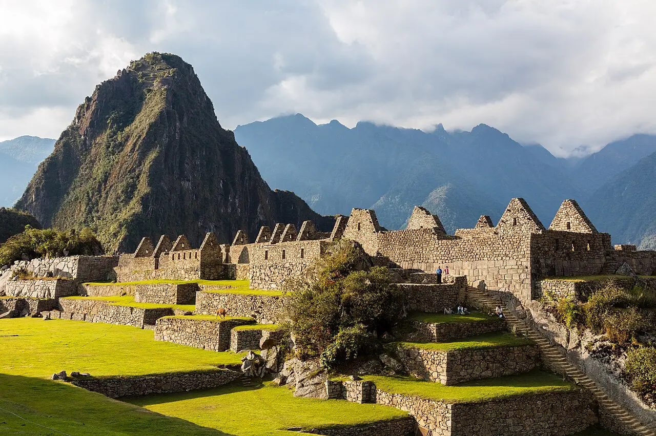
Machu Picchu
75 km as the crow flies, and a full day in practice: 2 hours by car to Ollantaytambo, 1 hour 30 minutes by train to Aguas Calientes, 30 minutes by bus to the entrance. The time slot and circuit are printed on the ticket, bought in advance. A same-day round trip exists, but it's an exhausting journey starting before dawn.

South Valley: Tipón, Pikillacta, and Andahuaylillas
A 45 km circuit to the southeast, about a 1-hour drive, with the Inca channels of Tipón still running, the Wari city of Pikillacta (6th to 11th centuries), and the church of Andahuaylillas, from 1626, with a painted ceiling and colonial organ. It's the least crowded trip and fits in half a day, with a chicharrón stop in Saylla.
Where to begin
Acclimatization: the colonial center over the Inca one
Arrive, drop your bags, and don't sleep the whole afternoon: walk slowly to the Plaza de Armas and sit down for a coca-leaf tea.
The stones above the city and the artisans' neighborhood
Take a taxi to Tambomachay and walk down past Puka Pukara, Q'enqo and Saqsaywaman.
Money
The currency is the sol (PEN, S/), at about 3.4 to the dollar and about 0.65 to the Brazilian real in September 2026. A menú del día with starter, main and a drink costs S/10–20 at a neighborhood restaurant, and a dish at a restaurant in the center, S/35–80; an espresso runs S/8–14 and a large bottle of Cusqueña beer, S/12–18. For lodging, budget S/30–60 for a hostel bed and S/180–350 a night at a mid-range hotel, and a short taxi ride is S/6–10. The biggest expense in Cusco is admission fees, more than food. The Boleto Turístico Integral costs S/130 for foreigners and is valid for 10 days, with partial versions by circuit at S/70. Machu Picchu costs S/152 on the regular circuit and S/200 on the circuits with a mountain, like Huayna Picchu, plus the Sernanp conservation fee, S/11, charged since May 2026; buy everything at tuboleto.cultura.pe. Cards work at hotels, agencies and restaurants in the center, but markets, combis, chicherías and street fairs take cash only. S/100 bills are often refused for small purchases, like a S/3–6 choclo, so break the bill at your hotel. Withdraw only once, because BCP charges S/15–20 per withdrawal, and BBVA and Scotiabank charge S/18–25, on top of your own bank's fee. Leave a 10% tip at tourist restaurants when “servicio” isn't on the bill, and round up at bars. For a trekking guide, agree on the daily rate with the agency before setting out.
Getting there and around
From the airport, 5 km from the Plaza de Armas
Alejandro Velasco Astete Airport (CUZ) is in Wanchaq, 5 km from the Plaza de Armas. It handles almost only domestic flights, with Lima about 1 hour 20 minutes away. The official taxi from the terminal to the center costs S/20–30 and takes 15–25 minutes. A ride-hailing app is cheaper, but the driver waits outside the parking lot, and you walk there with your luggage. By land, the Terminal Terrestre, on the Vía de Evitamiento, serves Puno (about 7 hours), Arequipa (about 10 hours) and Lima (about 21 hours). There's no road to Machu Picchu: the train leaves from Poroy, 14 km from the city, from Ollantaytambo, 60 km and about 2 hours by car, or, since May 2026, also from San Pedro station, in the center. PeruRail and Inca Rail run the line, with one-way tickets from $55–90 in the economy classes and more than $100 in the panoramic ones. From Aguas Calientes to the site entrance, the certified buses charge about $12 each way.
Combis with the route written on the windshield
Within the city, transport runs on privately operated combis and minibuses: a flat fare of S/1.00 to S/1.50, route written on the windshield. No app, no official map and no integrated ticket: you pay the conductor in coins. Taxis have no meter: agree on the fare before getting in, S/6–10 within the center and S/10–15 to the neighboring districts, more at night. InDrive and Uber operate in the city, alongside street taxis. The historic center can be crossed on foot in 20 minutes end to end, but it's uneven stone and slopes at 3,399 m. From the Plaza de Armas to San Blas is 500 m that takes 15 minutes uphill, and longer before you acclimatize. There's no metro or practical bike lane, and the vans to the Sacred Valley leave from informal terminals, not from a bus station.
Safety
For a city its size, Cusco is comparatively calm, and the main risk is theft: at San Pedro market, on crowded combis and outside the Plaza de Armas bars in the small hours. The dark streets climbing above San Blas and San Cristóbal also call for caution. The walking path to Saqsaywaman has seen muggings, so don't take it alone in the late afternoon. At night, use a taxi called by your hotel or through an app and never take one waiting on the street. Be wary of sidewalk agencies selling tours far below the average price, with no fixed office. The most common health problem is soroche, altitude sickness, which causes headache, nausea and insomnia in the first 24 to 48 hours and passes with rest, water and coca leaf tea. Symptoms that get worse call for descending or seeing a doctor; there are clinics with oxygen in the city. Don't drink tap water. Emergencies: 105 for police, 116 for the fire department. The Tourist Police and the iPerú desk, on Avenida El Sol, help in English and Spanish. When packing, remember that coca leaf is legal in Peru and illegal in most other countries: don't take it home in your luggage.
Etiquette tips
Write and say “Cusco,” not “Cuzco”
The spelling with a z is seen as a colonial holdover; the municipality has adopted Cusco and uses Qosqo, the Quechua form, in documents and on signs. No one corrects you out loud, but the difference is noted.
Pay for the photo of anyone posing
The women in traditional dress with lambs in the Plaza de Armas and San Blas are working when they pose: ask “¿una foto?” and leave S/2–5. Photographing them from afar without asking is their most frequent complaint.
Don't touch or climb on the Inca walls
The Twelve-Angled Stone has a guard, and contact is forbidden; the same goes for climbing on walls and terraces at Saqsaywaman or Ollantaytambo. The fine and the guard's scolding are real.
Accept the k'intu when it's offered
If someone hands you three stacked coca leaves, hold them with both hands, blow toward the mountain, and only then put them away or chew them. It is an offering to the apu, the protector mountain, and the gesture is what counts, with no right or wrong way to do it.
Greet before asking the price
Walking into a shop, stall or taxi with a straight “how much” comes across as rude; say “buenos días” or “allillanchu” first. In Quechua, saying “sulpayki” as thanks usually earns a smile and a small discount.
Haggle over crafts, not food
Haggling at craft markets is expected and goes to about 10–20% off the asking price. At food markets, restaurants and on transportation the price is the price; there you ask for “yapa,” a little extra, not a discount.
Mistakes to avoid
Going straight to 4,000 m on arrival day
Arriving from Lima, at sea level, and tacking on a trip to 4,000 or 5,000 m the same day, such as Vinicunca or Lake Humantay. It is the most common way to spend the following days with a headache and nausea. Keep the start of the trip, a day or two, for the city. Walk slowly, drink water and leave alcohol for later.
Buying Machu Picchu after arriving
Leaving the Machu Picchu ticket to buy after you get to Cusco. The daily quota is limited, and time slots and circuits sell out weeks or months ahead during high season. There's walk-up sale in Aguas Calientes, but only 1,000 a day, and only for the same day or the next. The ticket is valid for one fixed circuit and time slot, one-way flow, no re-entry.
Thinking you can drive there
Thinking you can drive to Aguas Calientes. The only ways there are by train, from Ollantaytambo, Poroy or San Pedro, or by the long route via Hidroeléctrica, with a 10 km walk along the tracks. Anyone who tries to go and return the same day gets back to Cusco in the small hours.
Booking the Inca Trail last minute
Planning the Inca Trail at the last minute. There are about 500 permits a day, counting guides and porters, sold months ahead by licensed agencies. The trail closes the entire month of February. Without a permit, the alternatives are Salkantay, Lares, or Choquequirao.
An international flight on the last day
Scheduling your international flight for the last day of the trip. Regional strikes and road or rail blockades happen fairly often, and have cut off access to Machu Picchu for days. Leave a 24-hour buffer before your flight home.
Useful phrases
Allillanchu?
How are you? A Quechua greeting (a-li-LYAN-choo); the reply is “allillanmi”
Sulpayki
Thank you, in Quechua (sul-PIE-kee); “añay” is also used
¿Cuánto cobra hasta la Plaza de Armas?
How much do you charge to the Plaza de Armas? Ask before getting in the taxi, which has no meter
¿Hay menú?
Is there a set lunch? The “menú” is the fixed-price lunch, with starter, main and a drink
Estoy con soroche
I have altitude sickness: a phrase understood at any pharmacy or front desk
La yapa, por favor
A little extra, please: the bonus you ask for at the market after closing the purchase
Where to stay
- Historic Center · First short trip, to do everything on foot · $$: The cathedral, the Qoricancha and the agencies are a few blocks away, on nearly flat streets. The trade-off is noise at night and touts on the square.
- San Blas · Couples, and anyone who wants quiet near the center · $$$: It is the most expensive and the quietest address in the center. The climb from the Plaza de Armas takes 15 minutes, and taxis cannot enter many of its streets.
- San Cristóbal · Anyone who wants a view and will walk to Saqsaywaman · $$: It sits on the slope below Saqsaywaman, with wider streets than San Blas, where taxis can reach. At night it is poorly lit.
- Santa Ana · Tight budget and backpacks · $: It has many hostels, northwest of the square, on a gentler slope than San Blas.
- Wanchaq and Avenida El Sol · Anyone who feels the altitude badly or arrives late · $$: It is flat and lies between the airport and the center, with pharmacies and clinics nearby. There is nothing to visit there.
$: hostel bed, S/30–60 · $$: mid-range hotel, S/180–350 a night · $$$: over S/350 a night · 2026-09-27
Districts
Historic Center
The ten blocks around the Plaza de Armas, with the cathedral, La Compañía, the agencies, the restaurants, and nearly every hotel. It concentrates what visitors see and also the money changers, the street touts, and the nighttime noise.
San Blas
The artisans' neighborhood, uphill northeast of the plaza, with narrow alleys, religious-carving and sculpture workshops, cafés, and viewpoints. It's the priciest address per square meter downtown, and the most tiring to climb on foot.
San Pedro
Around the central market, to the west, where the city does its real shopping: fruit, herbs, juices, lunch for S/10, and the informal van terminal for the Sacred Valley. Heavy foot traffic in the morning, and extra attention needed for pockets and bags.
San Cristóbal and Colcampata
The slope above downtown, over the terraces of the palace attributed to Manco Cápac, with the church of San Cristóbal and the best frontal view of the city. Residential neighborhood, poorly lit at night.
Wanchaq
Administrative and middle-class residential district to the southeast, with the Velasco Astete airport, the Wanchaq market, universities, and Avenida de la Cultura. It's where you handle paperwork, pharmacies, and clinics.
Santiago
Working-class district to the west and southwest, with the Almudena cemetery, the Molino market, and much of the city's working population. Little visited, and useful for understanding that Cusco is more than downtown.
San Sebastián and San Jerónimo
Old colonial settlements down the valley, now conurbated districts linked by Avenida de la Cultura. San Jerónimo hosts the Vinocanchón, the region's big wholesale produce market.
History
about 1000 BC · Villages in the Huatanay valley
Marcavalle and Chanapata pottery marks the oldest excavated agricultural occupation within the present-day city. The valley combines irrigable land, building stone, and the natural crossing point between the forest to the east and the high plateau to the southwest.
900–1200 · The Killke before the Incas
The Killke culture occupies the valley and builds the first structures on the Saqsaywaman hill. Radiocarbon dating released in 2008 confirmed Killke walls under the megalithic complex the Incas later expanded.
13th c. · Manco Cápac and the local lordship
Chronicles record the oral tradition that Manco Cápac arrived from Lake Titicaca with a gold staff and founded the lineage. Until 1438, Cusco is a regional lordship in permanent dispute with the Chancas to the northwest.
1438 · Pachacútec rebuilds Cusco in stone
After defeating the Chancas, Pachacútec redesigns the city, builds the Qoricancha and Saqsaywaman, and begins the expansion of the Tawantinsuyu. The Haukaypata plaza becomes the point where the roads of the four suyus meet.
1533–1534 · Conquest and Spanish refounding
The Spanish enter Cusco on November 15, 1533, at the end of the civil war between Huáscar and Atahualpa, and loot the gold that still remained in the Qoricancha, after much of the plating had already gone toward Atahualpa's ransom. On March 23, 1534, Pizarro refounds the city under Castilian law and divides the Inca palaces among his men.
1536–1572 · Manco Inca's siege and Vilcabamba
Manco Inca besieges Cusco starting in May 1536, using Saqsaywaman as a base, then retreats to Vilcabamba, where the Inca state holds out for 36 years. Túpac Amaru I, the last Inca of Vilcabamba, is executed in Cusco's main square in 1572.
1650 · Earthquake and Andean Baroque
The March 31, 1650 earthquake brings down much of the colonial city, and the Inca walls hold up what remained. The rebuilding produces the Andean Baroque and the cult of the Señor de los Temblores, whose Holy Monday procession reenacts that day.
1780–1781 · The rebellion of Túpac Amaru II
José Gabriel Condorcanqui leads the largest Indigenous revolt against the Crown and is executed on May 18, 1781 in the Plaza de Armas. The crackdown bans Indigenous dress, curaca titles, and the circulation of Garcilaso's Royal Commentaries.

1911 · Machu Picchu enters the foreign map
Hiram Bingham reaches Machu Picchu on July 24, 1911, led by farmers already cultivating the terraces. National Geographic devotes a full issue to the site in 1913, and Cusco starts receiving organized travel.
1950 · The earthquake that revealed the walls
On May 21, 1950, an earthquake damages about a third of the buildings downtown. The falling colonial plaster exposes whole Inca walls and sets the logic for the restoration seen today.

1983–2026 · UNESCO in 1983 and the Seven Wonders in 2007
UNESCO lists the city and Machu Picchu in 1983; the site's election as one of the New Seven Wonders, in 2007, multiplies the flows. After the 2020 closure and the 2023 road blockades, tourism went back to being the region's economic axis, under daily visitor quotas.

Complete history
Why Cusco was born in the Huatanay valley
Cusco exists because of geography: the Huatanay valley, at 3,399 m, combines irrigable land, stone that splits cleanly, and the natural passage between the montane jungle to the east and the Titicaca highlands to the southwest. There's Marcavalle pottery in the valley from about 1000 BC, and Killke walls at Saqsaywaman dated between 900 and 1200. When Pachacútec defeats the Chancas, around 1438, he doesn't found a new city: he rebuilds the one already there in carved stone, moves residents to the edges, and turns the center into a cluster of palaces, temples and storehouses where the elite and the temple staff lived.
The Qoricancha lines and the valley's three hundred shrines
As a capital, Cusco worked less as a city and more as an administrative and ritual center. From the Qoricancha radiated the ceque lines that organized more than three hundred shrines in the valley; from the Haukaypata plaza, the four roads set out that gave the suyus their names and connected to the roughly 40,000 km of the Qhapaq Ñan. Each dead Inca remained the owner of his palace and lands, managed by the panaca of his lineage, which forced each new ruler to conquer land to build his own house, and that's one of the explanations for the empire's continuous expansion in less than a hundred years.
The conquest caught the state at the end of a civil war
The conquest caught the Inca state at the end of a civil war between Huáscar, based in Cusco, and Atahualpa, based to the north. Much of the Qoricancha's gold plating had already gone toward Atahualpa's ransom when the Spanish entered the city, on November 15, 1533, looted what remained and refounded it on March 23, 1534, dividing the palaces among the conquistadors. Manco Inca's siege, in 1536, nearly drove out the Spanish and ended with Saqsaywaman turned into a quarry: for three centuries the colonial churches were built with blocks taken from there. Viceroy Toledo's Indian resettlements, from 1570, and the Potosí mining mita drained the population of the Cusco countryside.
The economic axis moved to silver and the coast
With the colonial economic axis shifted to silver and the coast, Cusco became a province rich in churches and poor in power. The 1650 earthquake produced the Baroque rebuilding and the Cusco School of painting, which exported canvases across Spanish America. The revolt of Túpac Amaru II (1780–1781) was crushed with a ban on Indigenous symbols. After independence, in 1821, the city stayed peripheral until the 20th century, when three things repositioned it: Bingham's arrival at Machu Picchu in 1911, the indigenist movement of the 1920s (Martín Chambi's photography, the San Antonio Abad university) and the 1950 earthquake, which, by bringing down the colonial plaster, exposed the Inca walls again and shaped all the restoration that followed.
Tourism begins in the 1970s and explodes later
Modern tourism began in the 1970s and exploded after 2007. Machu Picchu received about 1.5 million visitors in 2019, and it reopened with a controlled daily quota after the 2020 closure. The dependence is great enough that a regional strike, like the road and rail blockades of 2023, can halt the city's economy within days. The historic center has emptied of residents and filled with hotels and agencies, while residential growth has spread down the valley, into San Sebastián and San Jerónimo, and up the hillsides. The international airport at Chinchero, under construction 30 km away, is the bet to redistribute that flow, still without a confirmed opening date.
Geography and shape of the city
The valley and the shape of the puma
Cusco occupies the head of the Huatanay River valley, a tributary of the Vilcanota-Urubamba, at 3,399 m in the Cordillera Oriental. The historic center is wedged between two streams now channeled and covered by streets (the Saphy to the west and the Tullumayo to the east) that meet at Pumaqchupan, “the puma's tail”: the Inca layout of the city is read as the figure of a puma whose head would be Saqsaywaman, on the hill to the north.
The colonial grid and the slopes
The Spanish colonial grid was laid over that layout, which is why entire blocks have an Inca base and a colonial upper floor. The terrain runs the show: downtown is flat for two or three blocks around the Plaza de Armas and turns into a stone slope in every direction, with San Blas and San Cristóbal climbing to the north and northeast. The city grew down the valley, to the southeast, along Avenida de la Cultura, swallowing the old settlements of San Sebastián and San Jerónimo, and climbed the slopes in self-built neighborhoods.
The climate and the lower valley
The climate is tropical highland: strong sun and dry air from April to October, afternoon rain from November to March, cold nights year-round, and a daily temperature swing that can top 20 °C. The Sacred Valley, 600 m lower and 30 km to the north, is warmer and more fertile, which is why many people sleep there to acclimatize.
The Incas laid out Cusco in the shape of a puma, with Saqsaywaman as the head.
Culture
The Cusco School
The city produced its own school of painting between the 16th and 18th centuries: the Cusco School, made by Indigenous and mestizo artists trained by Europeans, recognizable by the gilded background applied in brocade, the absence of Renaissance perspective, and the entry of Andean elements into Christian scenes: archangels armed with arquebuses, virgins shaped like mountains, the cuy at the cathedral's Last Supper. Diego Quispe Tito, Basilio Santa Cruz Pumacallao, and Marcos Zapata are the central names, and the canvases traveled from Cusco to Bolivia, Argentina, and Chile. In the 20th century, Cusco indigenism made the same move with other media: the photographs of Martín Chambi (1891–1973), the Cusco Film School in the 1950s, and the San Antonio Abad university, founded in 1692.
Quechua is still alive
Cusco-Collao Quechua is still alive: it's co-official in the region, it's the first language in many of the rural communities, and it shows up in the city in street names, songs, and market transactions. The local Andean music (huayno, with charango, quena, and harp) shares space with the repertoire of downtown tourist peñas; to hear what's played at a neighborhood party you have to step off the Plaza de Armas axis. Textiles are the other major living craft: communities in Chinchero, Pitumarca, and Accha Alta keep natural dyeing with cochineal and chilca and designs that read as regional, work organized since 1996 by the Centro de Textiles Tradicionales del Cusco.
Cienciano and the unlikely title
In sports, Cienciano is the city's team and the only Peruvian club to win an international title: the 2003 Copa Sudamericana and the 2004 Recopa, played in part at the Inca Garcilaso de la Vega stadium, at 3,399 m, an altitude the club has always used to its advantage against visiting teams. Beyond the stadium, it's religion that sets the calendar: practically every month has a procession, and the same family that prays to a Catholic saint makes an offering to the apu, the protective mountain. Nightlife is modest and concentrated in the bars on the blocks around the Plaza de Armas, aimed at those just passing through; outside that core, the neighborhoods go to sleep early.
Mate de coca, coca-leaf tea, is the remedy locals use against altitude sickness.
Festivals and events
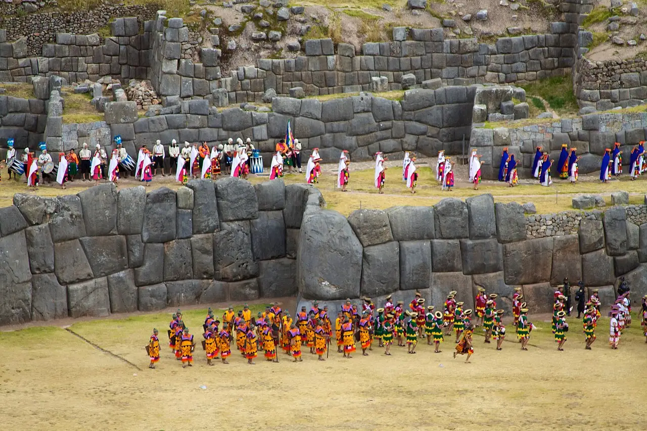
Inti Raymi, June 24
The festival of the sun, staged since 1944 based on Garcilaso's description, moves through the Qoricancha and the Plaza de Armas and ends at Saqsaywaman. Paid seating at Saqsaywaman costs upward of $90 and sells out; the route through the city is free and packed.
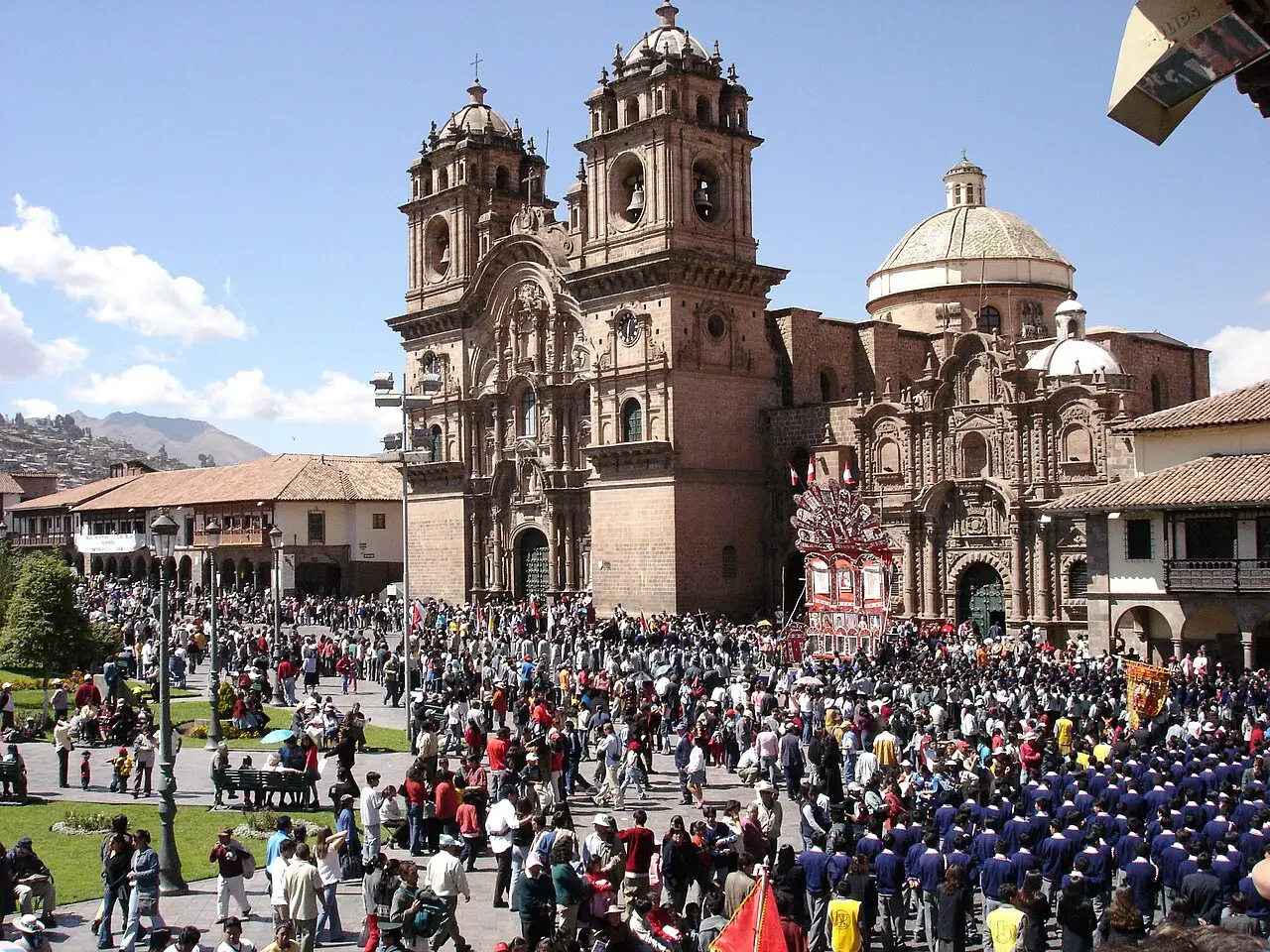
Corpus Christi, May or June
Fifteen images of saints and virgins are carried from the neighborhoods to the cathedral, where they spend the night together, with bands and crowds. On the eve and the day itself, people eat chiriuchu at the stalls in the square.
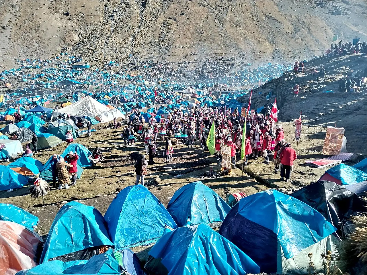
Qoyllur Rit'i, May or June
A pilgrimage of tens of thousands of people to the Sinakara sanctuary, at about 4,700 m, before Corpus Christi. It's been on UNESCO's intangible heritage list since 2011 and demands real acclimatization and cold-weather readiness.

Señor de los Temblores, Holy Monday
The procession of the darkened Christ that, according to tradition, stopped the 1650 earthquake. The square ends up covered in red ñucchu petals thrown from the balconies.
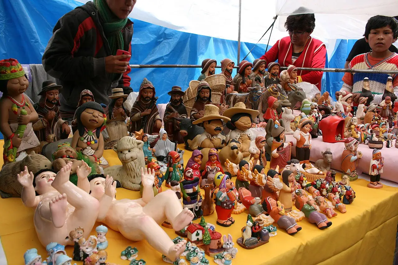
Santurantikuy, December 24
A centuries-old religious craft fair in the Plaza de Armas, devoted to nativity figures: above all the Niño Manuelito. It's set up in the morning and taken down on Christmas night.
Books and films
Royal Commentaries of the Incas (1609), Inca Garcilaso de la Vega
Son of a Spanish captain and an Inca noblewoman, born in Cusco in 1539, Garcilaso describes from memory the city of his childhood (the palaces, the Qoricancha, the festivals) just a few decades after the conquest. It's the source the modern Inti Raymi uses as its script.
Deep Rivers (1958), José María Arguedas
The novel opens with a boy and his father in front of the Inca walls of Cusco, and the stone is described as a living thing. It explains better than any guidebook the relationship between Quechua, the colonial city, and the Andean world around it.
The photographs of Martín Chambi (1891–1973)
Chambi photographed Cusco between the 1920s and 1950s: elite weddings, peasants, prisoners, giants, the 1950 earthquake, and a newly deforested Machu Picchu. The archive, published in several volumes, shows the city at the exact moment it starts to see itself as heritage.
Frequently asked questions
Cusco: how long does it take to reach Pisac, in the Sacred Valley?
Pisac is 33 km and 1 hour away, with a market and a set of terraces and tombs on the ridge above the village.
Cusco: what's the currency, and how much is the Brazilian real worth?
The currency is the sol (PEN, S/), at about 3.4 to the dollar and about 0.65 to the real in September 2026.
Cusco: what are the seasons like through the year?
Cusco has two seasons, split by rain, because daytime temperature changes little. The dry season, from April to October, has steady sun and 18°C to 21°C by day, with nights of 0°C to 5°C that in June and July reach −2°C, so it's worth packing a thermal layer for guesthouses with no heating. The rainy season, from November to March, has similar highs, lows of 6°C to 9°C and late-afternoon downpours, and January and February are the cloudiest months.
Cusco: is it correct to write Cusco or Cuzco?
Cusco, with an s: the spelling with a z is seen as a colonial leftover, and the municipality also uses Qosqo, the Quechua form, on documents and signs.
Cusco: what's the real risk for visitors?
For a city its size, Cusco is comparatively calm, and the risk that weighs most is theft: at the San Pedro market, on crowded combis and outside the Plaza de Armas bars in the small hours.
Other cities in the country
Peru ↗- Days
- 2–3
- When
- Jan–Apr
- Per person/day
- Average 350–550 S/Mid-range · per person/day
Cost scope
Per person per day: accommodation, meals, urban transport, visits and a small allowance for extras. Flights excluded; larger purchases vary. Editorial estimate, not a quote.
- Days
- 1–2
- When
- Apr–Oct
- Per person/day
- Average 425 S/Mid-range · per person/day
Cost scope
Per person per day: accommodation, meals, urban transport, visits and a small allowance for extras. Flights excluded; larger purchases vary. Editorial estimate, not a quote.
- Days
- 2–3
- When
- May–Oct
- Per person/day
- Explore costsGuide estimate
Cost scope
Per person per day: accommodation, meals, urban transport, visits and a small allowance for extras. Flights excluded; larger purchases vary. Editorial estimate, not a quote.
- Days
- 2–3
- When
- Apr–Nov
- Per person/day
- Average 209 PENMid-range · per person/day
Cost scope
Per person per day: accommodation, meals, urban transport, visits and a small allowance for extras. Flights excluded; larger purchases vary. Editorial estimate, not a quote.
- Days
- 2–3
- When
- Jan–Apr · Dec
- Per person/day
- Average 294 PENMid-range · per person/day
Cost scope
Per person per day: accommodation, meals, urban transport, visits and a small allowance for extras. Flights excluded; larger purchases vary. Editorial estimate, not a quote.