Colombia
San Andrés
Johnny Cay, snorkeling on the west coast and the Raizal island of La Loma
Days Start with the basic programme and choose extensions for the time you have.
How the guide reaches this number
The first is for Johnny Cay, on the 9am boat, with the afternoon on the Spratt Bight promenade. The second is the island loop on the circular road: the Baptist church of La Loma, the Casa Museo Isleña, the snorkeling at West View, the Hoyo Soplador and the end of the afternoon at Rocky Cay, in San Luis. The third is the Acuario in the morning and Cove bay in the afternoon. With three extra days, I'd go to Providencia, sleep there two nights and return to San Andrés a day before the flight home, because it is another island, mountainous and with a national park, and the small plane depends on the wind: on a day trip, a cancellation costs the whole day. I'd skip the Cueva de Morgan, which sells a treasure legend with no document behind it as an attraction. With fewer than three days, the COP 153,000 tarjeta weighs too much to see only the cays.
3–6
When February to April: the driest period, with 27 to 36 mm of rain per month in the 1991–2020 normal for the airport station; Holy Week, which falls in this period, fills flights and hotels, and from June to November it is hurricane season, with the rain peak in October and November
How the guide reaches this number
San Andrés is warm all year: in the 1991–2020 normal for the airport station, highs range from 28.8 °C to 30.8 °C and lows do not drop below 25 °C. What separates the seasons is rain and wind. February to April is the dry season, with 27 to 36 mm per month, the best for boats and snorkeling. May opens the rainy phase, which builds up to October and November, with about 317 mm per month, and the Atlantic hurricane season runs from June to the end of November: in November 2020 Hurricane Iota destroyed almost all the infrastructure of Providencia. On the days of strong waves, which boatmen associate with the end of August, the end of October and December, the boats to the cays do not leave. Crowding follows the Colombian calendar: December and January, Holy Week and the June and July school holidays are the peak periods, and in July 2026 hotel occupancy in the archipelago was 70.9%, the highest in the country. During the October school recess week, San Andrés is also among the Colombian destinations with the highest expected occupancy.
Per person/day Add up lodging per night, meals per person and each day's boat tours; the tarjeta de turismo is paid once, on arrival.
How the guide reaches this number
Per person per day: accommodation, meals, urban transport, visits and a small allowance for extras. Flights excluded; larger purchases vary. Editorial estimate, not a quote.
 What Nilo thinks
I'd stay three days in San Andrés. The first is for Johnny Cay, on the 9am boat, with the afternoon on the Spratt Bight promenade. The second is the island loop on the circular road: the Baptist church of La Loma, the Casa Museo Isleña, the snorkeling at West View, the Hoyo Soplador and the end of the afternoon at Rocky Cay, in San Luis. The third is the Acuario in the morning and Cove bay in the afternoon. With three extra days, I'd go to Providencia, sleep there two nights and return to San Andrés a day before the flight home, because it is another island, mountainous and with a national park, and the small plane depends on the wind: on a day trip, a cancellation costs the whole day. I'd skip the Cueva de Morgan, which sells a treasure legend with no document behind it as an attraction. With fewer than three days, the COP 153,000 tarjeta weighs too much to see only the cays.San Andrés is a Colombian island of 26 km² where a good share of the natives speak creole at home, English at church and Spanish in commerce. The Raizales descend from English Puritans and enslaved Africans who arrived from 1629, and the wooden Baptist church of 1847, on the heights of La Loma, is still the center of that community. The north of the island tells another story: since 1953 it has been a free port, and the center became a string of tax-free shops and all-inclusive hotels for visitors from the mainland. Around it all is the reef, which makes the sea change color with depth and protects the sand cays of Johnny Cay and the Acuario. On the west coast, with no beaches, coral rock forms natural pools where you swim among fish a few meters from the road. And 93 km to the northeast lies Providencia, mountainous and little built up, still recovering from the hurricane of 2020.
Quick facts
- Population
- 57,185 inhabitants on the island of San Andrés, an unincorporated area that is the capital of the department (DANE projection for 2026); the municipality of Providencia and Santa Catalina has 6,342
- Founding
- No founding date: the first European settlers, Puritans from the English Providence Island Company, arrived in the archipelago between 1629 and 1630; the island joined Gran Colombia on July 21, 1822
- Country and region
- Colombia; department of the Archipelago of San Andrés, Providencia and Santa Catalina, in the western Caribbean, 717 km in a straight line from Cartagena
- Language
- Spanish, English and San Andrés creole, English-based, spoken by the Raizal people and official in the archipelago since the 1991 Constitution
- Currency
- Colombian peso (COP, $)
- Time zone
- UTC−5 year-round, no daylight saving time
- Best time to visit
- February to April: the driest period, with 27 to 36 mm of rain per month in the 1991–2020 normal for the airport station; Holy Week, which falls in this period, fills flights and hotels, and from June to November it is hurricane season, with the rain peak in October and November
- Average daily cost
- Add up lodging per night, meals per person and each day's boat tours; the tarjeta de turismo is paid once, on arrival.
When to go
February to April: the driest period, with 27 to 36 mm of rain per month in the 1991–2020 normal for the airport station; Holy Week, which falls in this period, fills flights and hotels, and from June to November it is hurricane season, with the rain peak in October and November
How the year changes
San Andrés is warm all year: in the 1991–2020 normal for the airport station, highs range from 28.8 °C to 30.8 °C and lows do not drop below 25 °C. What separates the seasons is rain and wind. February to April is the dry season, with 27 to 36 mm per month, the best for boats and snorkeling. May opens the rainy phase, which builds up to October and November, with about 317 mm per month, and the Atlantic hurricane season runs from June to the end of November: in November 2020 Hurricane Iota destroyed almost all the infrastructure of Providencia. On the days of strong waves, which boatmen associate with the end of August, the end of October and December, the boats to the cays do not leave. Crowding follows the Colombian calendar: December and January, Holy Week and the June and July school holidays are the peak periods, and in July 2026 hotel occupancy in the archipelago was 70.9%, the highest in the country. During the October school recess week, San Andrés is also among the Colombian destinations with the highest expected occupancy.
Nilo's tips
Buy the tarjeta first and keep the receipt
The tarjeta de turismo costs COP 153,000 in 2026 and is paid before boarding, at the airline counter, or on the JetSmart website, for those flying with it. Children under 7 do not pay. Check whether the amount already came added to the ticket, so you do not pay twice, and keep the receipt: it is asked for again before departure and at the checks for Providencia.
Johnny Cay in the first hour
The park opens at 9am, closes at 4pm and takes up to 854 people at a time. With the 9am boat you get the whole opening time and come back with room to spare. Before going, check that it is not one of the three quarterly closing days, which Coralina announces on its official channels.
Snorkel on the west coast, without a boat
West View and La Piscinita are natural pools in the coral rock, a few meters from the circular road, with fish near the surface. For anyone who does not want to depend on open sea and boats, they are the best snorkeling on the island. Pick one of the two: the experience is similar.
The island loop with the price settled
The circular road is about 30 km. A golf cart gives freedom, but needs attention to the motorbikes; a taxi is calmer, as long as the day's price and the currency are agreed beforehand, because there are no meters. Be back in the center before 6pm, when the bus thins out in the south.
Between Providencia and the flight home, a spare day
The small plane to Providencia depends on the wind, and in February 2026 one flight could not land at El Embrujo because of strong wind. If Providencia is in the plan, go after your days in San Andrés, sleep there two nights and return to the main island a day before the international flight or the flight to the mainland: if the return from Providencia is delayed, the free day absorbs the delay.
Explore the map
Explore the map, read about the other places and plan your travel days in the app.
Open the appWhat to see
San Andrés: A coral island of 26 km²
San Andrés is about 13 km from north to south and 3 km wide. It formed from marine sediments and coral remains on an old submerged volcanic base: a low limestone ridge, La Loma, runs through the center, and the flat strips of the coast come from more recent reefs and sands. It is the most practical place to sleep on a first visit, and the busiest.

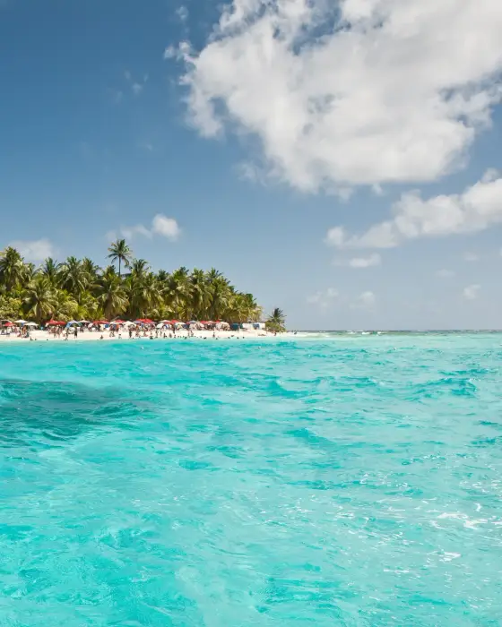
Johnny Cay
The largest of the cays around San Andrés, 1.5 km from the center and about 10 minutes by boat, is a regional park run by Coralina, with a white-sand beach and coconut palms. It is open from 9am to 4pm, with up to 854 visitors at a time, and closes three days every three months by court order, as well as on days of rough sea. Admission is COP 15,000, set by Coralina in Resolution 667 of 2021; Coralina sells the tickets to registered tourism companies, so ask whether the price of the boat or the tour already includes admission. Food is available on the cay itself, but you may not bring food or drink from outside, and swimming is allowed only inside the area marked by buoys.
The largest cay around the island is 10 minutes away by boat, but the Coralina park opens only from 9 a.m. to 4 p.m., with up to 854 visitors at a time, so the 9 a.m. boat makes the most of the day. It closes three days every three months by court order, as well as on days of rough seas.
Check access

West View
A natural pool in the coral rock of the west coast, without a beach, with water 3 to 10 m deep, and fish and corals near the surface. You can snorkel there without depending on a boat.
Snorkeling in coral rock beside the island’s ring road, without relying on a boat or sea conditions for trips to the cays, with water 3 to 10 m deep and fish near the surface.
Check access
El Acuario
Rose Cay, known as the Acuario for the fish that swim around bathers, is a sandbar about 15 minutes by boat from the center, next to Haynes Cay. Since the court ruling of August 2025 it is being reorganized: the old stalls were demolished, commerce is moving to new kiosks and the floating bridge that linked the two cays no longer exists. A Portafolio report from October 2026 describes boats with tourists docking at the remains of the bridge, but the court also ordered Haynes Cay closed three days every quarter, so confirm the day before.
The sandbar surrounded by fish is worth snorkeling, but it is being reorganized under a 2025 court order, with the bridge to Haynes Cay gone and the old stalls demolished; confirm the day before that it is open.
Check access
Spratt Bight
The urban beach of the North End, with the pedestrian promenade and the center's hotels around it. It is the beach for spare moments, next to Bahía Sardina, where the boats for the cays leave from. Since June 2026 staying in the sea between 6pm and 6am is forbidden.
The central urban beach, with a pedestrian promenade, fills the gaps between outings; since June 2026, entering the sea there is prohibited between 6 p.m. and 6 a.m.
Check access

First Baptist Church
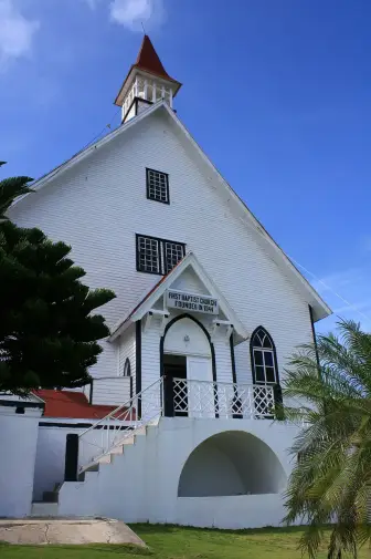
The Baptist church of La Loma, built in 1847 with pine brought from Alabama, is the oldest on the island and the center of Raizal religious life. It stands on the heights of La Loma, along the central road, with a view of the sea all around. It is a church in use: respect the hours of worship.
The church built in 1847 from Alabama pine is the island’s oldest and a center of Raizal life; the heights of La Loma offer a view of the reef.
Check access

Casa Museo Isleña
A house set up by locals to show how people lived on the island, on the west coast road. The visit presents the traditional house and Raizal customs, and it is where they teach raga raga, the island's emblematic dance.
Set up by islanders to show the traditional Raizal home and customs, this is where you learn raga raga, the island’s emblematic dance; it is on the way to the west coast’s snorkeling spots.
Check access

Rocky Cay
A small cay about 200 m from Cocoplum beach, in San Luis, reached by walking through shallow water. The hull of a shipwreck lies near it, and the beach opposite has white sand and shallow water.
The cay lies about 200 m off Cocoplum beach and can be reached on foot through shallow water, with a shipwreck hull nearby, without needing a boat.
Check access
Hoyo Soplador
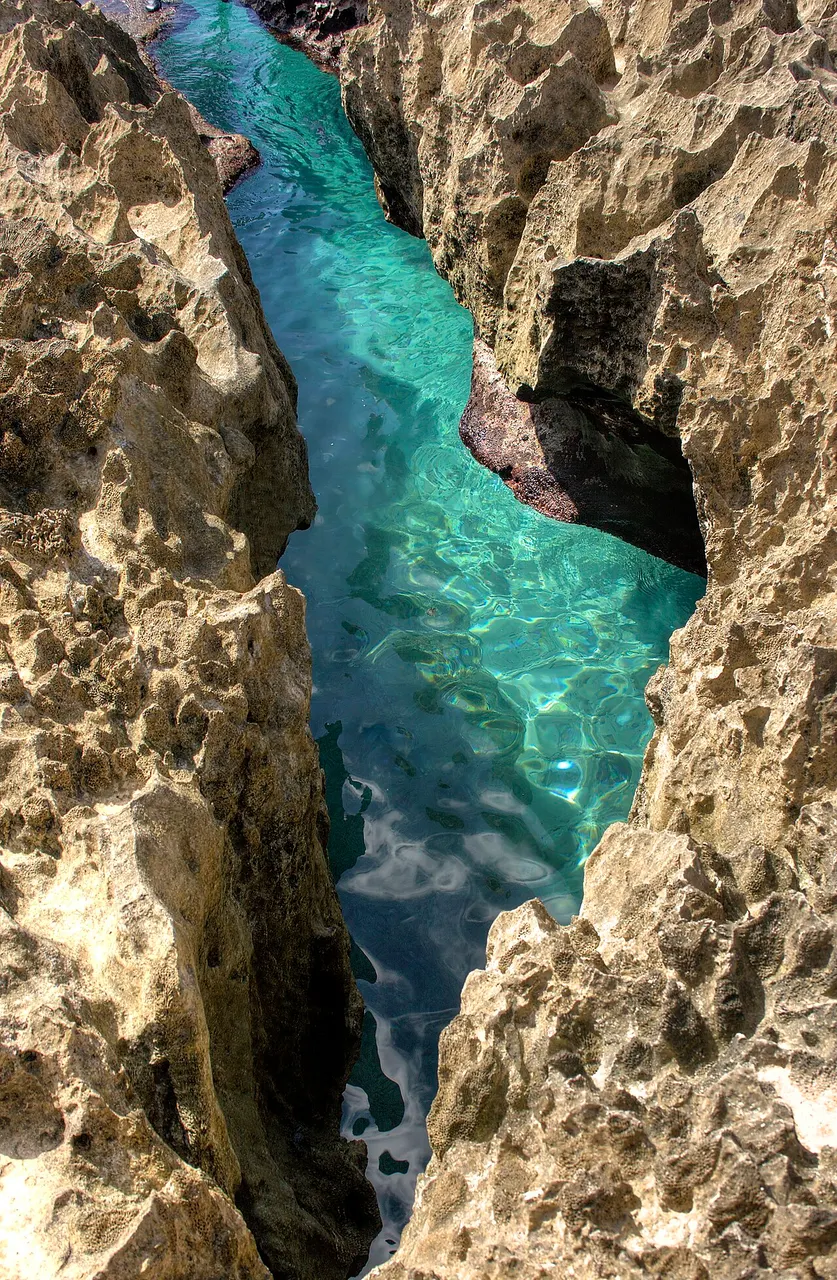
On the southern point, a hole in the rock connected to an underground cave: when a wave comes in hard, water and air shoot out of the hole in a jet. The force depends on the sea, and on a calm day almost nothing happens. What you spend money on there is the vendors at the site.
The jet appears only when waves enter forcefully; almost nothing happens on calm days, and the stop has persistent vendors. Include it on a circuit of the island when the sea is rough.
Check access
La Piscinita
Another natural pool on the west coast, about 1.5 km south of West View, with calm water and fish around. For anyone who has already been to West View, the experience is very similar.
A natural pool similar to West View, 1.5 km to the south, worthwhile only for those wanting a second swim on the same day.
Check access
Nilo’s itinerary
Start with the basic programme and choose extensions for the time you have.
Plan my days in the app ↗Day 1 · Johnny Cay and the North End
Be at Bahía Sardina beach, in the center, before 9am and take a shared boat to Johnny Cay, about 10 minutes away; the park opens at 9am.
Check with the boat company whether the park admission (COP 15,000) is already in the price, stay inside the swimming area marked by buoys and do not bring food or drink from outside.
Have lunch on the cay itself, which has food available, and head back before 4pm, when the park closes.
In the late afternoon, walk along the Spratt Bight promenade and the free-port shopping area; be out of the sea before 6pm.
Day 2 · The island loop: La Loma, the west coast and the south
Rent a golf cart or arrange a taxi for the day, with the price settled beforehand.
Go up to La Loma and stop at the First Baptist Church, from 1847, for the view of the reef; if you like, continue to Laguna Big Pond, nearby.
Go down to the west coast and visit the Casa Museo Isleña.
Snorkel at West View in the late morning; La Piscinita, a little to the south, is an alternative.
Continue to the Hoyo Soplador, on the southern point, and see whether the sea is strong enough for the jet.
Go up the east coast to San Luis and finish at Cocoplum beach, wading across to Rocky Cay; return to the center before dark.
Day 3 · The Acuario and the sunset at the Cove
Confirm the day before whether the Acuario and Haynes Cay are open and whether the sea allows the boats to leave.
Leave in the morning from Bahía Sardina for the Acuario, about 15 minutes by boat, and snorkel in the shallow water around the sandbar.
Return to the center in the early afternoon.
Go to Cove bay, on the west coast. Fishermen's Place is open Monday to Friday from 12pm to 6pm, so on a weekday have lunch there; on Saturdays, Sundays and holidays it stays open until 10pm, and you can have dinner of rondón or crab soup while watching the sunset, which happens between 6pm and 6:55pm depending on the season.




If you stay longer
Day 4 · Providencia and Santa Catalina
Day trip
Located 93 km northeast of San Andrés, Providencia is volcanic, mountainous and much less built up, with 6,342 inhabitants (DANE projection for 2026) and a pedestrian bridge of about 100 m to Santa Catalina. Here are the Old Providence McBean Lagoon National Natural Park, with mangrove, reef and a visitor center on Crab Cay, reachable by boat, and The Peak, the highest point, at 360 m. You get there in about 15 to 20 minutes by plane (Satena or Searca) to El Embrujo airport, or by catamaran, which in August 2024 left on Mondays, Wednesdays and Fridays and took 2h30 to 3h; confirm operation for your travel dates. The tarjeta de turismo is also valid there and may be asked for at the checks between the islands. The island is still rebuilding after Hurricane Iota, in 2020: stay at least two nights and book ahead.
Day 5 · Free day
Free day: use it to rest, go back to the place you liked most or cover a setback.
Day 6 · Free day
Free day: use it to rest, go back to the place you liked most or cover a setback.
Food
Rondón
The most traditional dish of the islands, whose name comes from the English “run down”: fish fillet, conch, pig tail, cassava, yam, plantain and dumplings, wheat-flour balls, slowly cooked in coconut milk.
Sopa de cangrejo (crab soup)
Creamy black crab soup with coconut milk, vegetables and spices. It is on the menu at Fishermen's Place in the Cove alongside rondón and fried fish.
Crab patty
A wheat-dough turnover filled with crab meat seasoned with bell pepper, garlic and onion. It is hand-held food, for a snack.
Fish ball
A ball made with fish of any kind, a sort of meatball of the comida isleña kitchen.
Plantain tart
A sweet plantain empanada, sold on the street in the afternoon, mostly in La Loma.
Breadfruit
The fruit of the breadfruit tree, common on the island, eaten fried, with a taste between potato and cassava. It goes with fish.
Coco loco
A drink served inside the coconut itself, sold at stops on the island loop, such as the Hoyo Soplador.
Where to eat
- Fishermen's Place del Cove · El Cove · $$
Rondón, crab soup and fried fish in a comida isleña space rebuilt by the Gobernación, facing the sunset. Open Monday to Friday from 12pm to 6pm and on Saturdays, Sundays and holidays from 12pm to 10pm.
Source · 2026-10-15
- La Loma · $
Plantain tart, the sweet plantain empanada sold on the street in the afternoon.
- San Luis · $$
Comida isleña in the restaurants of San Luis: rondón, crab patty and fish with fried breadfruit.
- North End (El Centro) · $
Lunch special, or corrientazo, the dish of the day with soup, meat or fish, rice and salad, in the restaurants of the center.
$: dish of the day in the center, plantain tart or crab patty on the street · $$: rondón or fried fish in a comida isleña restaurant · $$$: hotel restaurant or international menu in the center · 2026-10-15
Day trips
Providencia and Santa Catalina
Located 93 km northeast of San Andrés, Providencia is volcanic, mountainous and much less built up, with 6,342 inhabitants (DANE projection for 2026) and a pedestrian bridge of about 100 m to Santa Catalina. Here are the Old Providence McBean Lagoon National Natural Park, with mangrove, reef and a visitor center on Crab Cay, reachable by boat, and The Peak, the highest point, at 360 m. You get there in about 15 to 20 minutes by plane (Satena or Searca) to El Embrujo airport, or by catamaran, which in August 2024 left on Mondays, Wednesdays and Fridays and took 2h30 to 3h; confirm operation for your travel dates. The tarjeta de turismo is also valid there and may be asked for at the checks between the islands. The island is still rebuilding after Hurricane Iota, in 2020: stay at least two nights and book ahead.
Cayo Bolívar
An isolated cay about 33 km southeast of the airport, in open sea, sought out for diving. You can only get there on a boat tour booked with an operator; ask about the duration, check that the company is registered and go only with a calm-sea forecast.
Where to begin
Johnny Cay and the North End
Be at Bahía Sardina beach, in the center, before 9am and take a shared boat to Johnny Cay, about 10 minutes away; the park opens at 9am.
The island loop: La Loma, the west coast and the south
Rent a golf cart or arrange a taxi for the day, with the price settled beforehand.
Money
The currency is the Colombian peso (COP), written with the $ symbol. Because it is a free port, San Andrés sells perfumes, drinks and clothes without the tax charged on the mainland, and the center is full of shops; compare prices and check that bottle caps are not rusty, a sign of damp storage. There are two charges that do not always show up in the package price. The tarjeta de turismo costs COP 153,000 per person in 2026, the sum of COP 116,000 for the tarjeta and COP 37,000 as a contribution to tourist infrastructure, under Decree 0010 of January 8, 2026; children under 7 and residents with an up-to-date OCCRE card are exempt. Admission to Johnny Cay is COP 15,000 (Coralina Resolution 667 of 2021), and Coralina sells the tickets to registered tourism companies: when you book the boat or the tour, ask whether admission is included.
Getting there and around
Getting there: by air only, with the tarjeta bought beforehand
Gustavo Rojas Pinilla International Airport (ADZ) is in the North End, about 2 km from Spratt Bight; the trip to the hotels in the center is by taxi, with the price agreed beforehand, because there are no meters. It receives direct flights from Bogotá, Medellín, Cali and Cartagena, and Copa has connected the island with Panama City for 20 years; JetSmart alone operated 35 weekly flights from Medellín, Bogotá and Cali in July 2026. There is no regular passenger boat from the mainland. The tarjeta de turismo is paid before boarding, at the airline counter, and JetSmart sells it on its own website, when you buy the flight.
Getting around the island: circular road, bus, taxi and golf cart
A circular road of about 30 km goes around the island, and from Spratt Bight it is about 12 km to West View and 15 km to the Hoyo Soplador. The San Luis city bus line goes down to the south of the island, but gets scarce after 6pm. Taxis have no meters: agree the price beforehand, and say which currency you will pay in. A rented golf cart is the most common way to go around on your own, and motorbikes move fast everywhere.
Boats to the cays
The boats to Johnny Cay and the Acuario leave from Bahía Sardina beach, in the center, as shared or chartered service. Choose a registered company and do not board an overcrowded boat: the government of Canada reports accidents in San Andrés with unlicensed tourist boats. When the waves are strong, especially at the end of August, the end of October and in December, the boats do not leave.
To Providencia
Satena and Searca fly from San Andrés to El Embrujo airport in Providencia in about 15 to 20 minutes, and strong wind sometimes prevents landing; in August 2024 Satena charged COP 220,000 to 300,000. In August 2024 there was also a catamaran on Mondays, Wednesdays and Fridays, with a crossing of 2h30 to 3h, for COP 220,000, and rough seas at the peak of the waves. Book in advance and confirm schedules and prices, which have no more recent source.
Safety
The government of Canada, in its update of October 14, 2026, recommends only normal precautions in the city of San Andrés and in Providencia, a lower level than for the rest of Colombia. The most concrete risks are in the sea. For Colombia in general, Canada warns that there are beaches without lifeguards and without warning flags and that rip currents are common; in San Andrés, since June 2026 staying in the sea between 6pm and 6am is forbidden, and the island government records tourists going into the water after drinking. Choose a boat from a registered company, with life jackets, and do not board a crowded boat: Canada cites accidents in San Andrés with unlicensed tourist boats, and in February 2026 a tourist suffered a serious spinal injury after falling in a boat at Johnny Cay. On land, phone and wallet theft happens as in the rest of the country, and insistent vendors at the stops on the island loop, such as the Hoyo Soplador, have caused fights with tourists: refuse firmly and move on. From June to November, follow the Gobernación's cyclone alerts.
Etiquette tips
Raizal is not a synonym for resident
Raizal is the native people of the archipelago, of British and African roots, Protestant and creole-speaking. Many residents of the center came from the mainland after 1953. Calling everyone Raizal, or treating creole as “broken English”, ignores an official language with its own grammar.
At Johnny Cay the park rules apply
The park forbids bringing food and drink, alcohol, taking rocks, shells, plants and animals, and swimming outside the area marked by buoys. Follow the instructions of the Coralina staff.
Do not buy coral or conch as a souvenir
Pieces of coral and shell sold as souvenirs fuel the removal of these animals from the reef. Eating turtle is forbidden, and other species have closed seasons: ask before ordering conch or lobster.
Agree the price before the ride
Taxis on the island have no meters. Ask the price, say which currency you will pay in and only then get in the car.
In church, dress as you would for worship
The First Baptist Church is a church in use, and the service is in English. Anyone who wants to attend comes in quietly and in suitable clothes, not beachwear.
Mistakes to avoid
Reaching the airport without the tarjeta
The tarjeta de turismo is bought before boarding, at the airline counter or, with JetSmart, on the website. Without it you cannot enter the archipelago, and it is asked for again before departure: keep the receipt until the return flight.
Going into the sea after 6pm
Since June 2026 Decree 0205 forbids staying in the sea between 6pm and 6am, because there are no lifeguards at night. The police patrol the beaches, and the government records tourists going into the water after drinking, which greatly increases the risk of an accident.
Counting on the Acuario bridge
The 204 m floating bridge between the Acuario and Haynes Cay, opened in 2023, broke loose and was not rebuilt; boats dock at its remains. The cay is also being reorganized by court order, with stalls demolished.
Scheduling Johnny Cay for the afternoon
The park is open from 9am to 4pm and has a limit of 854 visitors at a time, according to Coralina in 2024. Anyone who leaves after lunch has little time on the cay.
Drinking tap water
Tap water comes from wells and desalination plants and is not potable. Use bottled water even for brushing your teeth, if you prefer not to take the risk.
Coming back from Providencia on the day of your flight home
The small plane to Providencia depends on the wind, and rough sea or weather cancels crossings. Leave a free day in San Andrés between the return from Providencia and the flight out of the archipelago.
Useful phrases
Tarjeta de turismo
The entry card that every visitor pays before boarding for the archipelago
¿Cuánto cuesta la lancha a Johnny Cay?
How much is the boat to Johnny Cay?
¿A qué hora sale la última lancha?
What time does the last boat leave?
¿Cuánto me cobra hasta el centro?
How much do you charge me to the center? (to agree the taxi fare beforehand)
Les go!
Let's go! (in San Andrés creole)
Kom ya!
Come here! (in San Andrés creole)
Beg no du ih!
Please, don't do that! (in creole; “beg” at the start of a sentence is the polite way to ask)
Where to stay
- North End (El Centro) · First trip, for those who want to do everything on foot and leave early for the cays · $$: The airport, the shops, the restaurants and the boat dock are a few blocks away, and Spratt Bight beach is right in front. In exchange, it is the busiest and noisiest part of the island.
- San Luis · Families and anyone who wants calm sea at the door · $$: The east coast has shallow beaches, such as Cocoplum, and hotels more spread out. To get to the center and the boats, count on the bus by day, a taxi or a golf cart.
- La Loma and San Luis, in a posada nativa · Anyone who wants to stay with Raizal families and speaks English or Spanish · $: The posadas nativas are bed-and-breakfasts run by Raizal families, with a home-cooked breakfast, and many owners speak English and creole. They are far from the commerce of the center, so they depend on transport.
- North End, in an all-inclusive hotel · Anyone traveling on a package who does not want to think about meals · $$$: The all-inclusive chains cluster several hotels in the center and in San Luis. It is convenient, but it keeps you away from the comida isleña, which is eaten in the Cove and in San Luis.
$: posada nativa or hostel · $$: mid-range hotel in the center or in San Luis · $$$: all-inclusive hotel · 2026-10-15
Districts
North End (El Centro)
The northern tip holds the departmental government, the banks, the free-port shops, most of the hotels and the airport. Spratt Bight beach, with its pedestrian promenade, is here, and the boats for the cays leave from the sand of the center. It is the most practical place to sleep on a first visit, and the busiest.
La Loma
The high center of the island, among hills, is inhabited mostly by Raizales and keeps the traditional wooden architecture. The First Baptist Church, from 1847, is here, and the plantain tart is sold on the streets of La Loma.
San Luis
A mostly Raizal village on the east coast, with many of the island's calm-water beaches, such as Cocoplum, opposite Rocky Cay, as well as restaurants serving comida isleña and hotels more spread out than those in the center.
West coast and El Cove
The west side, without beaches, is that of coral rock and the natural snorkeling pools: West View and La Piscinita. In Cove bay stands Fishermen's Place, a comida isleña restaurant reopened in December 2025, from where you can watch the sunset on Saturdays, Sundays and holidays, when it stays open until 10pm.
Punta Sur (South End)
The more isolated southern point has the Hoyo Soplador and stretches of rocky coast. Public transport gets scarce after 6pm, and anyone who comes here at night needs a car, a golf cart or a pre-arranged taxi.
History
1527 · The island appears on maps
The archipelago first appears on an anonymous universal chart from 1527. Spain claimed the islands but did not settle them: they were far from the mainland and ringed by reefs.
1629–1641 · The Puritans of the Providence Island Company
English Puritan settlers, coming from Bermuda, Barbados and England, settle in the archipelago, mostly on Providencia, and bring enslaved Africans to grow cotton and tobacco. The colony raids Spanish ships and falls to Spain in 1641.
1670 · Henry Morgan uses the islands as a base
The Welsh privateer Henry Morgan takes the islands and uses them as a base to attack Panama. The legend of a hidden treasure survives in the names of places such as the Cueva de Morgan.
1803 · Under the Viceroyalty of New Granada
At the request of governor Tomás O'Neille, a royal order of November 20, 1803 moves the archipelago and part of the Mosquito Coast from the Captaincy General of Guatemala to the jurisdiction of Santa Fe de Bogotá.
1822 · Joining Gran Colombia
After the occupation by the French privateer Luis Aury, in the service of independence, the flag of Gran Colombia is raised in Providencia on June 23 and in San Andrés on July 21, 1822.
1834 · Emancipation
The islands adopt the British law that abolished slavery, passed a year earlier. The act, led by Pastor Philip Beekman Livingston, is remembered every August 1 as Emancipation Day.
1847 · The Baptist church of La Loma
The First Baptist Church is built, with pine brought from Alabama, on the heights of La Loma. The church taught English to the formerly enslaved and became the center of Raizal life.
1912 · Intendancy separate from Bolívar
After a campaign by the newspaper The Searchlight, run by Francis Newball, Law 52 of October 26, 1912 creates the Intendancy of San Andrés and Providencia, separate from the department of Bolívar.
1953 · Free port
The government of General Gustavo Rojas Pinilla declares San Andrés a free port. Tax-free trade draws tourists and migrants from the mainland, and the island's population grows from about 20,000 in 1973 to more than 55,000 in 2005.
1991–2000 · Department and biosphere reserve
The 1991 Constitution turns the intendancy into the department of the Archipelago of San Andrés, Providencia and Santa Catalina and recognizes creole as an official language in the territory. In 2000 UNESCO includes the archipelago in the Seaflower Biosphere Reserve.
2012 · The Hague ruling
On November 19, 2012 the International Court of Justice confirms Colombian sovereignty over the islands and cays, but redraws the maritime boundary with Nicaragua, and Colombia loses part of the sea around the archipelago.
2020 · Hurricane Iota
In November 2020 Hurricane Iota, a Category 5 storm, destroys about 98% of the infrastructure of Providencia and Santa Catalina; damage in San Andrés is smaller. In 2026 reconstruction is still under way.
Complete history
Islands of Puritans, privateers and enslaved people
For more than a century Spain claimed the archipelago without settling it, because the islands were small, far from the mainland and protected by reefs that were hard to navigate. The ones who settled were the English: between 1629 and 1630 the Providence Island Company brought Puritan settlers, mostly to Providencia, which had fresh water and mountains for defense. They brought enslaved Africans for cotton and tobacco and used the islands as a base for raiding Spanish ships, until the colony fell in 1641. In 1670 Henry Morgan made this place his base for attacking Panama. From this mix of British settlers and Africans descend the Raizal people, who gave the island its Protestant religion, its English and its creole.
Colombian by choice, Caribbean by culture
In the 19th century the archipelago passed from Guatemala's orbit to that of New Granada, joined Gran Colombia in 1822 and, in 1834, took up the end of slavery decreed by Great Britain a year earlier. Its real ties, however, were with the English-speaking Caribbean: Jamaica, the Mosquito Coast and Panama. The First Baptist Church, from 1847, taught English to the formerly enslaved, and worship in English survived even when the Colombian state, between 1902 and 1926, tried to impose Spanish, and when English was banned in public schools, in 1946, and in private ones, in 1956. The islanders rejected United States proposals to separate from Colombia in 1902 and 1903, and in 1912 they won an administration of their own, separate from Bolívar.
The free port changes the island
The turning point came in 1953, when Gustavo Rojas Pinilla declared San Andrés a free port. With flights from the mainland and tax-free goods, the island became a shopping destination and a beach-package destination for Colombians, and received migrants from the mainland and merchants from the Middle East. The population went from about 20,000 people in 1973 to more than 55,000 in 2005, and people from the mainland came to make up about two thirds of the island's population. Hence the dispute over land and water, the residence restrictions controlled by OCCRE, the office that issues the resident card, and the Raizal movement for autonomy, which gained strength after the 2012 Hague ruling.
The sea under pressure
Since 2000 the archipelago has been part of the Seaflower Biosphere Reserve, and the environmental authority, Coralina, manages the regional parks of Johnny Cay and the Old Point mangrove. The pressure of mass tourism has reached the courts: Johnny Cay closes three days every three months by court order, and in August 2025 the archipelago's administrative court ordered the Acuario closed for six months and its commerce reorganized, because of erosion and lack of sanitation. In 2026 the archipelago charges each visitor a tarjeta de turismo of COP 153,000, part of it earmarked for tourist infrastructure.
Geography and shape of the city
A coral island of 26 km²
San Andrés is about 13 km from north to south and 3 km wide. It formed from marine sediments and coral remains on an old submerged volcanic base: a low limestone ridge, La Loma, runs through the center, and the flat strips of the coast come from more recent reefs and sands. There are no permanent rivers. A circular road of about 30 km goes around the island, and almost every excursion follows it.
The northeast reef and the cays
The northeast of the island is ringed by a coral reef, and between it and the coast lie the shallow water and the sand cays: Johnny Cay, 1.5 km from the center, and the Acuario and Haynes Cay, to the east. It is the changing depth over sand, reef and deep water that gives the sea its bands of green, turquoise and blue, which Colombians call the “mar de los siete colores”. The west coast has no beaches: it is coral rock, with natural pools good for snorkeling, such as West View and La Piscinita.
Constant heat and rain in the second half of the year
At the airport station, the 1991–2020 climate normal gives highs of 28.8 °C to 30.8 °C and lows of 25.2 °C to 26.5 °C through the year. What changes is the rain: from February to April 27 to 36 mm fall per month, and in October and November, about 317 mm. The Atlantic hurricane season runs from June to the end of November. Providencia, 93 km to the northeast, is different: it is volcanic and mountainous, with its highest point at The Peak, at 360 m.
The “mar de los siete colores” is the variation in depth over sand, reef and deep water seen from above: from the heights of La Loma it appears in full.
Culture
The Raizal people and the creole language
The Raizales descend from the British settlers and the enslaved Africans who populated the islands from the 17th century. Most speak three languages: San Andrés creole among themselves, English, mostly in church, and Spanish. Creole, with English vocabulary and its own grammar, is a close relative of Belize kriol and of the creoles of the Caribbean coast of Nicaragua and Costa Rica, and has between 20,000 and 30,000 speakers. Since 1991 it has been official in the archipelago, and Colombia recognizes the Raizales as a people with collective rights, including prior consultation.
Baptist church, music and dance
Most Raizales are Protestant, mainly Baptist, and the church preserves English in Bible reading, worship and choirs. The island's music blends calypso, soca, reggae and church music, and traditional dances include the mazurka, the polka, the schottische, the quadrille and the mento, which came from the Antilles. At the Casa Museo Isleña you can learn raga raga, the island's emblematic dance.
An island of many origins
The free port brought migrants from mainland Colombia and merchants from the Middle East to the island, and San Andrés has a mosque and a synagogue alongside its Baptist, Adventist and Catholic churches. The most popular sport is basketball, with local teams that have played in the Colombian professional league.
The posadas nativas
The posadas nativas are guesthouses run by Raizal families, in a bed-and-breakfast format, with a home-cooked breakfast. Many owners speak English and creole, and it is the most direct way to stay close to island life outside the all-inclusive hotels.
In San Andrés creole, “beg” at the start of a sentence is the polite way to ask: “Beg no du ih!” means “please, don't do that”.
Festivals and events
Emancipation Week: the week ending August 1
The week commemorates the 1834 emancipation with debates, art and activities on Raizal identity, and leads up to Emancipation Day on August 1. In 2025 it marked its 25th year, with the theme “Conciencia Raizal”. Check the program on the Gobernación's website.
Barracuda Fest: August
A Caribbean music festival created by the Gobernación, with its first edition on August 22 and 23, 2025, featuring local and outside artists. The dates of later editions are announced by the Gobernación.
Black crab migration in Providencia: April and May
It is not a festival, but it is the best-known natural event in the archipelago: the black crabs that live in the hills of Providencia go down to the sea in great numbers to spawn once a year.
Books and films
Providence Island, 1630–1641: The Other Puritan Colony (1993), Karen Ordahl Kupperman
The historian reconstructs the Puritan colony that the Providence Island Company set up in the archipelago at the same time as New England, and explains how it became a base for raiding and slavery until it fell to Spain. It is the origin of the Raizal people told through the documents.
The Island That Disappeared: Old Providence and the Making of the Western World (2017), Tom Feiling
A book on the history of Old Providence, as the English called Providencia, and the island's role in the formation of the Atlantic world, as the subtitle announces. In English.
Keyla (2017), by Viviana Gómez Echeverry
The first fiction feature shot in Providencia, with non-professional actors: a teenage girl from the island looks for her father, who disappeared at sea. It shows the life and landscape of San Andrés's neighboring island.
Frequently asked questions
San Andrés: how do you get from the airport to the hotel?
The airport (ADZ) is in the North End, about 2 km from Spratt Bight. The trip to the hotels in the center is by taxi, with the price and the currency agreed beforehand, because there are no meters.
San Andrés: what is the tarjeta de turismo, and how much does it cost?
The tarjeta de turismo costs COP 153,000 per person in 2026, and children under 7 and residents with an OCCRE card are exempt. It is paid before boarding, at the airline counter or on the JetSmart website, and without it you cannot enter the archipelago.
San Andrés: how many days should I stay?
I'd stay three days: Johnny Cay on the 9am boat, the island loop on the circular road and the Acuario in the morning. With three extra days, I'd go to Providencia, sleep there two nights and return to San Andrés a day before the flight home.
San Andrés: how do you get to Providencia, and is it worth a day trip?
Satena and Searca fly to Providencia in about 15 to 20 minutes, and strong wind sometimes prevents landing; in August 2024 there was also a catamaran of 2h30 to 3h. On a day trip, a cancellation costs the whole day, so stay there at least two nights.
San Andrés: when is the best time to go?
February to April is the dry season, with 27 to 36 mm of rain per month, and the best for boats and snorkeling, but Holy Week fills flights and hotels. May opens the rainy phase, and the hurricane season runs from June to the end of November.
Other cities in the country
Colombia ↗- Days
- 2–3
- When
- Jan–Feb · Jul–Aug
- Per person/day
- Average 239,000 COPMid-range · per person/day
Cost scope
Per person per day: accommodation, meals, urban transport, visits and a small allowance for extras. Flights excluded; larger purchases vary. Editorial estimate, not a quote.
- Days
- 2–3
- When
- Jan–Apr · Dec
- Per person/day
- Average 80–130 USDMid-range · per person/day
Cost scope
Per person per day: accommodation, meals, urban transport, visits and a small allowance for extras. Flights excluded; larger purchases vary. Editorial estimate, not a quote.
- Days
- 3–4
- When
- Jan–Mar · Jul–Aug · Dec
- Per person/day
- Average 45–90 USDMid-range · per person/day
Cost scope
Per person per day: accommodation, meals, urban transport, visits and a small allowance for extras. Flights excluded; larger purchases vary. Editorial estimate, not a quote.
- Days
- 3–4
- When
- Jan–Apr · Dec
- Per person/day
- Average 151,000 COPMid-range · per person/day
Cost scope
Per person per day: accommodation, meals, urban transport, visits and a small allowance for extras. Flights excluded; larger purchases vary. Editorial estimate, not a quote.