United States
Grand Canyon
Grand Canyon, the South Rim of the abyss carved by the Colorado River
Days Start with the basic programme and choose extensions for the time you have.
How the guide reaches this number
On the first day, I'd hike a short stretch of the South Kaibab or the Bright Angel Trail early, walk the Rim Trail and the Trail of Time between the Yavapai Geology Museum and Grand Canyon Village, and watch the sunset on Hermit Road. On the second, I'd drive the 37 km of Desert View Drive to the Desert View Watchtower, stopping at Navajo Point while Lipan Point is closed (until December 23, 2026), and from there continue to Page through the east entrance or return to the rim. Driving there and back from Las Vegas in a single day means nine hours behind the wheel (900 km round trip) and reaching the canyon under harsh midday light and lines.
2
When April to May and September to October; spring and fall have clear days on the rim and less extreme temperatures on the trails, while summer crowds the viewpoints and pushes the canyon floor above 40 °C.
How the guide reaches this number
April to May and September to October deliver the best combination on the South Rim: pleasant highs at the top (between 15 °C and 24 °C), cold, clear nights for stargazing and temperatures bearable enough to hike the first kilometers of the South Kaibab or the Bright Angel Trail. From late May to late August (Memorial Day to Labor Day), the village lots fill by mid-morning, monsoon thunderstorms tend to build on July and August afternoons (with a risk of lightning on the rim and flash floods in the canyons) and the heat at the bottom of the gorge easily passes 40 °C in the shade. From November to March, the South Rim stays open with far fewer lines and beautiful scenery when snow covers the pines and the red rocks, but temperatures drop below freezing at night, the trailheads form sheets of ice (requiring crampons on your shoes) and Hermit Road reopens to private cars in December, January and February.
Per person/day Budget around USD88; mid-range around USD203; comfortable around USD398 per person per day, based on spending reported by travelers to Budget Your Trip (checked October 2026).
How the guide reaches this number
Indicative figures, excluding travel to the destination.
Budget around USD88; mid-range around USD203; comfortable around USD398 per person per day, based on spending reported by travelers to Budget Your Trip (checked October 2026). Indicative figures, excluding travel to the destination.
Per person per day: accommodation, meals, urban transport, visits and a small allowance for extras. Flights excluded; larger purchases vary. Editorial estimate, not a quote.
 What Nilo thinks
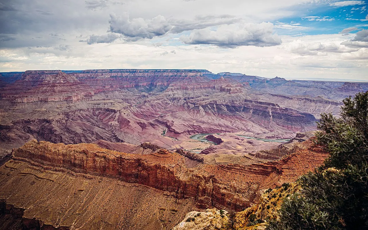
I'd stay two full days and two nights near the South Rim: inside the park once its hotels reopen (Xanterra expects arrivals from November 20, 2026) or, in the meantime, in Tusayan, 11 km from the rim, or in Williams, 95 km away. On the first day, I'd hike a short stretch of the South Kaibab or the Bright Angel Trail early, walk the Rim Trail and the Trail of Time between the Yavapai Geology Museum and Grand Canyon Village, and watch the sunset on Hermit Road. On the second, I'd drive the 37 km of Desert View Drive to the Desert View Watchtower, stopping at Navajo Point while Lipan Point is closed (until December 23, 2026), and from there continue to Page through the east entrance or return to the rim. Driving there and back from Las Vegas in a single day means nine hours behind the wheel (900 km round trip) and reaching the canyon under harsh midday light and lines.I'd go to the Grand Canyon by the South Rim, the National Park's, and not by the West Rim walkway that many Las Vegas tours sell as if it were the same place. The South Rim has what makes the canyon fit in your head: viewpoints such as Mather Point and Yavapai Point, from which the walls drop in colorful steps to a river you can barely see, and a village of hotels and stone shops that Mary Colter designed to look like part of the rock.
Read more
What I wouldn't skip is going down a little below the rim. From above, the canyon looks like a flat painting; on a short stretch of the South Kaibab or the Bright Angel Trail, walls of almost two billion years rise around you and the depth is felt in your legs, above all on the way back, which is all uphill. In the late afternoon, the low light changes the color of the layers from one Hermit Road viewpoint to the next, and at night the park's dark sky shows the Milky Way.
Quick facts
- Population
- About 1,800 residents in Grand Canyon Village, inside the park (census-designated place, 2020 census), and about 600 in Tusayan, the gateway town next to the south gate (2020 census).
- Founding
- Ancestral homeland of eleven associated Native American tribes; declared a National Monument in 1908 by Theodore Roosevelt, a United States National Park on February 26, 1919, and a UNESCO World Heritage Site in 1979.
- Country and region
- United States, northern Arizona (Coconino and Mohave counties), Colorado Plateau.
- Language
- English. The park's planning guide (Trip Planner) comes in German, Chinese, Korean, Spanish, French, Italian and Japanese versions, to download from the National Park Service website.
- Currency
- US dollar (USD). The national park entrance stations do not accept cash (cards and digital passes only).
- Time zone
- America/Phoenix (Mountain Standard Time): UTC-7 all year, because Arizona does not observe daylight saving time (between March and November the time matches Las Vegas and California; note that the neighboring Navajo Nation does observe daylight saving time).
- Best time to go
- April to May and September to October; spring and fall have clear days on the rim and less extreme temperatures on the trails, while summer crowds the viewpoints and pushes the canyon floor above 40 °C.
- Average cost per day
- Budget around USD88; mid-range around USD203; comfortable around USD398 per person per day, based on spending reported by travelers to Budget Your Trip (checked October 2026). Indicative figures, excluding travel to the destination.
When to go
April to May and September to October; spring and fall have clear days on the rim and less extreme temperatures on the trails, while summer crowds the viewpoints and pushes the canyon floor above 40 °C.
How the year changes

April to May and September to October deliver the best combination on the South Rim: pleasant highs at the top (between 15 °C and 24 °C), cold, clear nights for stargazing and temperatures bearable enough to hike the first kilometers of the South Kaibab or the Bright Angel Trail. From late May to late August (Memorial Day to Labor Day), the village lots fill by mid-morning, monsoon thunderstorms tend to build on July and August afternoons (with a risk of lightning on the rim and flash floods in the canyons) and the heat at the bottom of the gorge easily passes 40 °C in the shade. From November to March, the South Rim stays open with far fewer lines and beautiful scenery when snow covers the pines and the red rocks, but temperatures drop below freezing at night, the trailheads form sheets of ice (requiring crampons on your shoes) and Hermit Road reopens to private cars in December, January and February.
Nilo's tips
Do the math on the 2026 annual pass for non-residents
With the surcharge of 100 USD per person aged 16 or older added to the 35 USD for the car, I'd buy the America the Beautiful Non-Resident Annual Pass (250 USD) if I were three adults in the same vehicle, or two who were also going to another of the eleven parks with the surcharge, such as Zion or Bryce Canyon. Horseshoe Bend and Antelope Canyon, near Page, are outside this math: the first has municipal parking and the second can only be visited on a guided Navajo tour.
Hike down to Ooh Aah Point right after sunrise
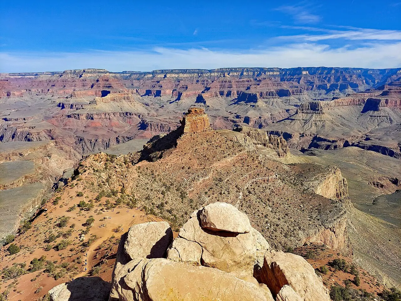
Instead of walking only on the asphalt along the rim or attempting a long, dangerous descent in the heat, I'd take the orange bus early to the South Kaibab Trailhead and hike the 1.4 km down to Ooh Aah Point: it takes about an hour to an hour and a half round trip and completely changes your sense of the canyon's depth.
Park at the Visitor Center and use the bus lines
From mid-morning on, fighting for a space near the El Tovar hotel in the historic village only wastes time. I'd leave the car in the big lots at the Grand Canyon Visitor Center (Lots 1 to 4) and do everything between the Rim Trail and the blue, orange and red buses.
Enter from the south and leave by the east if you're going to Page
If the trip continues to Horseshoe Bend and Antelope Canyon, I wouldn't go back through the Tusayan south gate: driving the Desert View Drive viewpoints and leaving by the Desert View east entrance toward Cameron saves road and already includes the 1932 Watchtower on the way.
Explore the map
- Mather Point
- Yavapai Point and Yavapai Geology Museum
- Rim Trail and Trail of Time
- Grand Canyon Village Historic District (El Tovar, Hopi House and Lookout Studio)
- Bright Angel Trail
- South Kaibab Trail to Ooh Aah Point and Cedar Ridge
- Hermit Road (Hopi Point, Mohave Point, The Abyss and Pima Point)
- Desert View Watchtower
- Lipan Point
Explore the map, read about the other places and plan your travel days in the app.
Open the appWhat to see
Mather Point
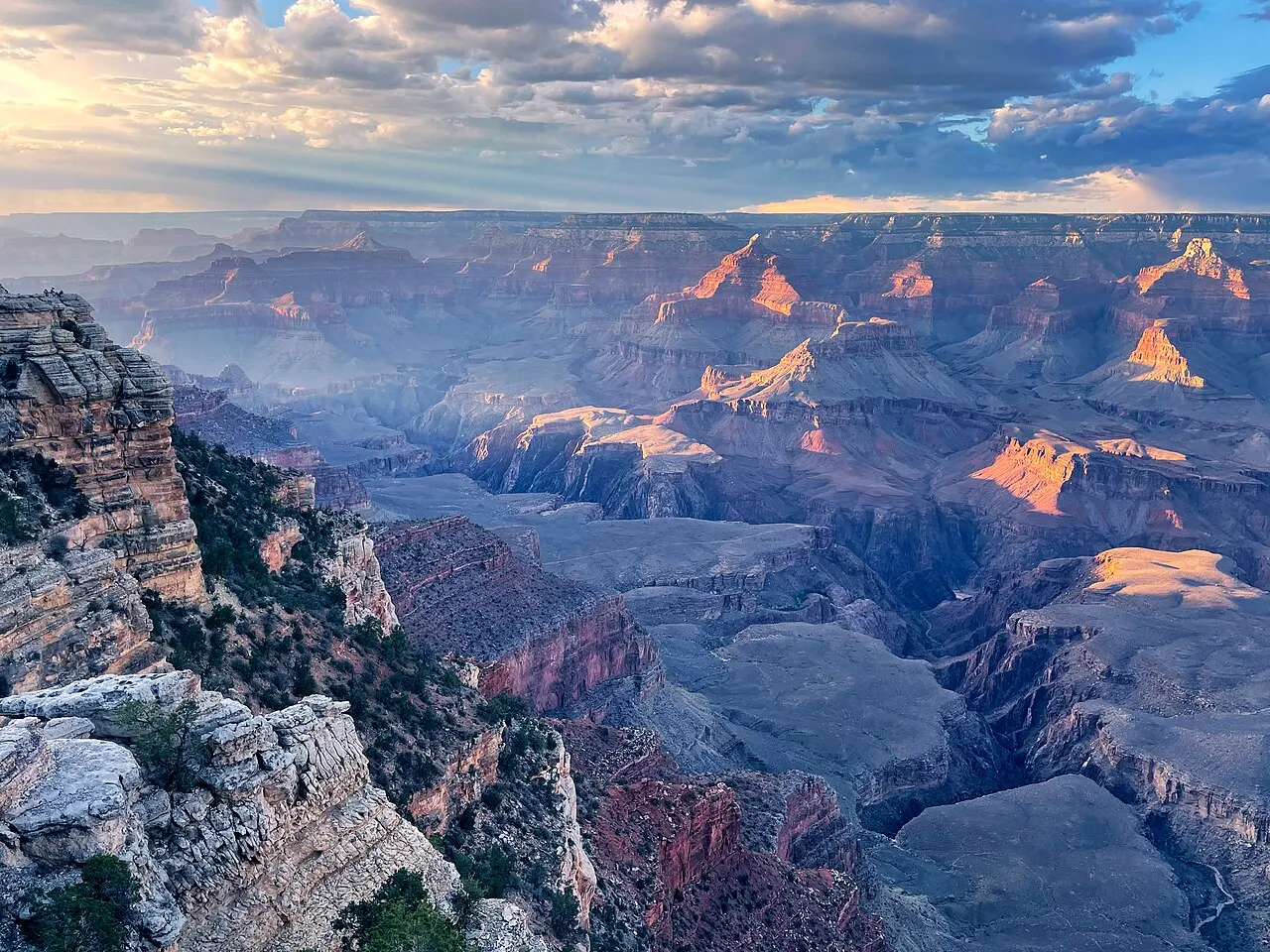
Located a five-minute flat walk from the Grand Canyon Visitor Center, it is the first view of the canyon for most visitors. Two rock promontories with guardrails jut out over the abyss and, on clear days, show a wide stretch of the central canyon, with the Bright Angel Trail visible in the distance. Because it receives the groups that have just parked, it is crowded from mid-morning to late afternoon; fifteen minutes of walking on the Rim Trail toward Yavapai Point is enough to find room at the wall.
Check access

Yavapai Point and Yavapai Geology Museum
About 1.1 km west of Mather Point along the paved rim path (or by a stop on the shuttle's orange line), the Yavapai Point overlook was chosen by geologists in the 1920s as the point on the South Rim from which you can best see the canyon floor, the suspension bridge near Phantom Ranch and the layout of the trails all at once. The historic stone museum has floor-to-ceiling glass windows, topographic models and panels explaining how the Colorado River cut through the plateau.
Check access

Rim Trail and Trail of Time
The Rim Trail follows the South Rim for about 21 km between the South Kaibab Trailhead (to the east) and Hermits Rest (to the west). The central stretch between Mather Point, Yavapai Point and Grand Canyon Village is paved, nearly flat and wheelchair accessible. Along it runs the Trail of Time, a geological timeline marked on the ground in which each meter represents one million years. It is 4.56 km long in all, and the main stretch, about 2 km, runs from the Yavapai Geology Museum (the most recent time) to Grand Canyon Village (the oldest rocks in the canyon), with real samples of each layer beside the path.
Check access
Grand Canyon Village Historic District (El Tovar, Hopi House and Lookout Studio)
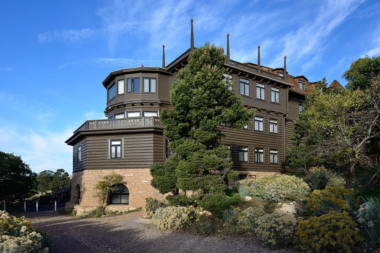
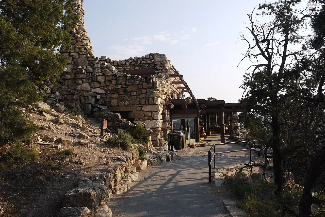
The historic district preserves the atmosphere of the railroad's early years at the edge of the abyss. The El Tovar hotel, opened in 1905 with Oregon pine logs and local stone, stands next to Hopi House (1905), Mary Colter's first project, inspired by the stone pueblos of Oraibi, and Lookout Studio (1914), whose limestone terrace looks like a natural continuation of the cliff. Farther on, at the fireplace of Bright Angel Lodge (1935), Colter stacked rocks in the same stratigraphic order as the canyon, from Colorado River pebbles on the floor to Kaibab limestone at the top.
Check access
Bright Angel Trail
It starts directly from the rim in Grand Canyon Village, next to Kolb Studio, following a natural geological fault. It is the park's most structured inner trail, but it demands absolute respect for the elevation change and the heat: on a half-day visit, go down only as far as the first or second tunnel cut into the rock, or to the Mile-and-a-Half Resthouse rest stop (2.4 km down and about 340 m of elevation change, which take twice as long to climb back). Those who prefer not to walk can book with Xanterra the mule ride to Havasupai Gardens, which goes down this trail, or the Canyon Vistas Mule Ride, which stays on the rim. Always check the NPS notices page (Key Hiking Messages) the day before: after work on the Transcanyon aqueduct and the August 2026 flood, stretches below the Mile-and-a-Half Resthouse or Havasupai Gardens may be closed and the water taps turned off, which also applies to the mule ride.
Check access
South Kaibab Trail to Ooh Aah Point and Cedar Ridge
Unlike the Bright Angel Trail, which descends tucked into a side canyon, the South Kaibab Trail follows the open spur of a ridge, offering 360-degree panoramic views within the first few steps. The trailhead is on a road closed to private cars: arrive by the free orange-line bus (Kaibab Rim Route) or by the early-morning Hikers' Express. There is no drinking water anywhere and almost no shade: for a safe morning hike, go to the Ooh Aah Point overlook (about 2.9 km round trip and 180 m of elevation change) or to the Cedar Ridge plateau (4.8 km round trip and 340 m of elevation change), where there are composting toilets.
Check access
Hermit Road (Hopi Point, Mohave Point, The Abyss and Pima Point)
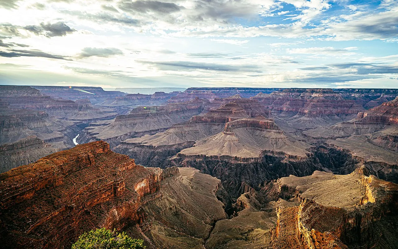
The 11 km west of the historic village hold some of the best late-afternoon angles. From March to November, you board the red bus (Hermit Road Route) and can hop off at one overlook and walk the Rim Trail to the next: Maricopa and Powell Point (with the memorial to the 1869 expedition) lead to Hopi Point, the most famous for sunset because it juts far to the north; a little farther on, Mohave Point and Pima Point let you see and even hear the roar of Granite Rapids on the Colorado River below, while The Abyss shows a nearly vertical drop of 900 meters.
Check access
Desert View Watchtower
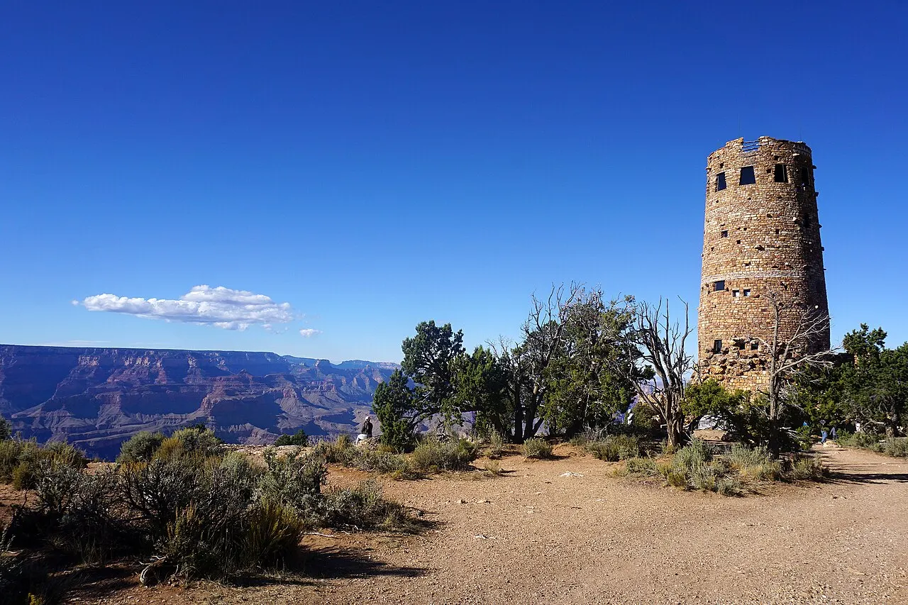
At the eastern end of the South Rim, 37 km from Grand Canyon Village on Highway 64, stands the 21-meter stone tower completed by Mary Colter in 1932, inspired by the ancestral towers of Hovenweep and the Round Tower at Mesa Verde. On the ground floor, the Kiva Room is the rest room with a fireplace and windows onto the canyon that Colter imagined; on the first landing, the Hopi Room holds murals by the Hopi artist Fred Kabotie about the origins of the Hopi people, and the ceiling has paintings by Fred Geary that reproduce the rock art of the Abo Rockshelter in New Mexico. From the outdoor terrace you see the great bend where the Colorado River turns from south to west, as well as the Painted Desert and the Navajo Nation to the east.
Check access

Lipan Point
Located on Desert View Drive just before Desert View, it is the east-side overlook with the longest view of the Colorado River: the Hance Rapid rapids, the old delta of Unkar Creek (inhabited by Puebloan peoples between 850 and 1200 CE) and the red, tilted layers of the Grand Canyon Supergroup. Lipan Point and its access road are closed to the public from June 22 to December 23, 2026; until it reopens, Navajo Point, less than 1 km away and the highest overlook on the South Rim, shows the Watchtower and the river to the north.
Check access
Nilo’s itinerary
Start with the basic programme and choose extensions for the time you have.
Plan my days in the app ↗Day 1 · Sunrise on the rim, a short trail descent, the historic village and Hermit Road
Park early at the Grand Canyon Visitor Center and start by watching the first light of morning at Mather Point, or take the free orange-line bus to Yaki Point.
To feel the canyon from the inside without risking the midday heat, ride the orange line to the South Kaibab Trailhead and go down only as far as Ooh Aah Point (2.9 km round trip) or Cedar Ridge, carrying water and a salty snack; for a gentler alternative, hike the first stretch of the Bright Angel Trail to the rock tunnels.
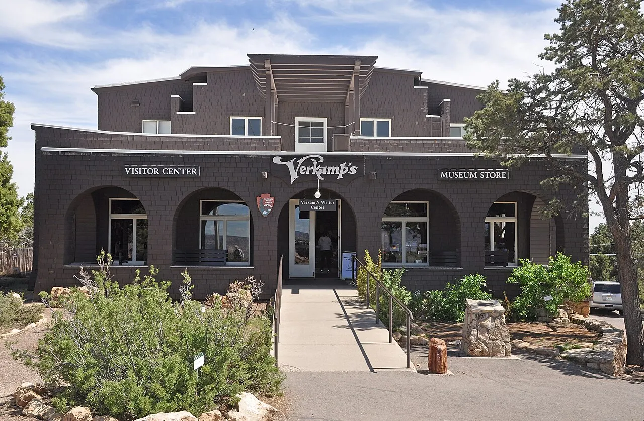
In the late morning, visit the Yavapai Geology Museum and walk the roughly 2 flat kilometers of the Trail of Time along the rim to Grand Canyon Village: see Verkamp's Visitor Center, Hopi House, the El Tovar hotel, Lookout Studio and Kolb Studio, and have lunch at the village lodges or at Market Plaza.
In the afternoon, take the free red-line bus along Hermit Road: get off at Powell Point and walk the Rim Trail to Hopi Point and Mohave Point to see the Colorado River below, continue by bus to the historic cabin at Hermits Rest and watch the sunset at Hopi Point or Pima Point before dinner.
Day 2 · The 37 km of Desert View Drive to the Watchtower and out the east side
Spend the morning on the complementary walk left pending in the historic village or on a stretch of the Bright Angel Trail very early (checking the NPS water and opening notices first).
Take the car and drive the 37 km of Desert View Drive (Highway 64) to the east at an easy pace, stopping first at Grandview Point (2,256 m of elevation) and at Moran Point.
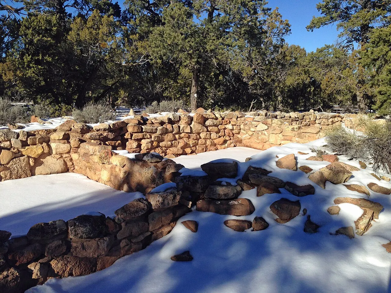
Pause at Tusayan Ruin to see the foundations of the Ancestral Puebloan settlement from about 1185 CE and continue to Navajo Point, the highest overlook on the South Rim, with a view of the Colorado River to the north. Lipan Point, just before it, is closed from June 22 to December 23, 2026; after that, it is worth a stop for the Hance Rapid rapids and the tilted layers of the Supergroup.
Finish at the Desert View Watchtower, the stone tower of 1932 designed by Mary Colter with murals by Fred Kabotie, taking in the great bend of the Colorado River and the Painted Desert; from there, drive back along the road for sunset or leave directly through the east entrance toward Cameron and Page.



Food
Southwestern cuisine and Navajo-Hopi influence
On the South Rim and on the road between Cameron and Flagstaff, the region's most memorable dish is the Navajo Taco, served on frybread (puffy, soft fried bread) topped with pinto beans, ground beef or green chili, lettuce, cheddar cheese and tomato, along with lamb stews and posole corn stew.
Historic Fred Harvey Company dining rooms (El Tovar and Arizona Steakhouse)
Eating facing the abyss in the log dining room of the El Tovar Dining Room (1905) or at Bright Angel Lodge ties the trip to the railroad history of the West, with dishes of trout, bison, beef cuts and chili. Since the August 2026 flood, some of these dining rooms have closed or moved to reduced hours, and in October the El Tovar Dining Room was not among those open: check the Xanterra notices before counting on it. With normal service, dinner at El Tovar requires a reservation, and the concessionaire recommends reserving breakfast and lunch as well.
Salty snacks and trail calorie replacement
On hikes inside the canyon, drinking only plain water in large quantities without replacing sodium can cause severe hyponatremia (water intoxication). The National Park Service itself advises combining hydration with salty snacks (pretzels, salted nuts, electrolyte bars and sandwiches) bought the day before at the Canyon Village Market (Market Plaza).
Where to eat
- Grand Canyon Village (historic district on the rim)
Since the August 2026 flood, the village restaurants have been running with reduced service. In Xanterra's notice of October 13, 2026, the Harvey House Café at Bright Angel Lodge was serving only breakfast and lunch, the Arizona Steakhouse only dinner, and the El Tovar Dining Room, the Fred Harvey Tavern and the Maswik dining rooms were not among those open. With normal service, El Tovar requires a dinner reservation and the concessionaire recommends reserving breakfast and lunch as well. For a quick coffee before the trail, the Canyon Adventures Bike Tours and Café, on the Visitor Center plaza, has an espresso bar and takeout snacks. Check Xanterra's notices and the NPS restaurants page the day before.
- Market Plaza (Canyon Village Market and Yavapai Lodge)
The Canyon Village Market supermarket is the best place inside the park to buy fruit, salty snacks and gallons of water before taking the bus to the trails or driving Desert View Drive; the attached delicatessen was closed at the October 2026 check. Next door, at Yavapai Lodge, the Yavapai Café serves coffee and snacks and the Yavapai Lodge Tavern lunch and dinner, both listed as open on the NPS restaurants page in September 2026.
- Desert View and Cameron (east corridor)
At Desert View, the Desert View Market and Deli and the Trading Post, with coffee and ice cream, sit next to the Watchtower. Those leaving by the east entrance toward Page will find at the historic Cameron Trading Post (open since 1916 on US-89) the classic place to try a hearty Navajo Taco on freshly fried frybread.
· 2026-10-17
Day trips
Williams and Historic Route 66
About 95 km south of the South Rim on Highway 64 (1 hour by car), Williams preserves whole blocks of the old Route 66 with diners, neon signs and the railroad station from which the historic Grand Canyon Railway train leaves every morning (2 hours 15 minutes each way to the park village).
Flagstaff, Walnut Canyon and Sunset Crater Volcano
About 130 km southeast of the park (1 hour 30 minutes by car via US-180 or US-89), the university and railroad town of Flagstaff sits at 2,100 meters of elevation at the foot of the San Francisco Peaks; here are the Lowell Observatory (where Pluto was discovered in 1930) and two neighboring national monuments: the Native dwellings built into the crevices of the Walnut Canyon cliffs and the black lava fields of Sunset Crater Volcano.
Page, Horseshoe Bend and Antelope Canyon
Leaving by the Desert View east gate and heading north on US-89 through Cameron, Page is about 175 km from the Desert View Watchtower (or 215 km from Grand Canyon Village, about 2 hours 15 minutes to 2 hours 30 minutes by car). It is the classic combination of the trip: the overlook above the 300-meter horseshoe of the Colorado River at Horseshoe Bend (a short walk exposed to the sun, with paid municipal parking) and the orange sandstone slot canyons of Upper and Lower Antelope Canyon, which lie on Navajo Nation territory and require a guided tour booked in advance.
Sedona and Oak Creek Canyon
About 180 km south of the South Rim (2 hours by car, passing through Flagstaff and descending the winding scenic AZ-89A highway through the wooded gorge of Oak Creek Canyon), Sedona contrasts the immense scale of the Grand Canyon with nearby formations of vivid red sandstone (such as Cathedral Rock and Bell Rock), art galleries and half-day trails.
Where to begin
Sunrise on the rim, a short trail descent, the historic village and Hermit Road
Park early at the Grand Canyon Visitor Center and start by watching the first light of morning at Mather Point, or take the free orange-line bus to Yaki Point.
The 37 km of Desert View Drive to the Watchtower and out the east side
Spend the morning on the complementary walk left pending in the historic village or on a stretch of the Bright Angel Trail very early (checking the NPS water and opening notices first).
Money
The currency is the US dollar (USD). The Grand Canyon National Park entrance stations do not accept cash: bring a credit or debit card, or the pass bought beforehand. For those who do not reside in the United States, the 2026 math changes with the 100 USD surcharge per person aged 16 or older, charged on top of the 35 USD for the car: two adults pay 235 USD and three pay 335 USD, while the America the Beautiful Non-Resident Annual Pass costs 250 USD for a year and covers the car with its occupants. The pass pays off from three adults in the same car, or from two who also visit another of the eleven parks with the surcharge (among them Zion, Bryce Canyon and Yosemite); check the table at `nps.gov/grca/planyourvisit/fees.htm` before buying. Lodging inside the park (Xanterra and Delaware North, suspended since August 31, 2026) and at the Tusayan hotels have high rates between March and October, plus state and local taxes; filling up in Williams, Valle or Cameron is usually cheaper than at the gas stations in Tusayan or Desert View.
Getting there and around
When building the itinerary from Las Vegas, keep the distinction exact: the West Rim, where the Skywalk glass walkway on Hualapai Nation land is, is 200 km away (2 hours 15 minutes by car) and is not part of the National Park; the South Rim, with Mather Point, Grand Canyon Village, the Bright Angel Trail and Desert View Drive, is 450 km from Las Vegas (4 hours 30 minutes by car via US-93, I-40 and AZ-64) and calls for an overnight stay. In Arizona, the nearest airports are Flagstaff Pulliam (FLG, about 130 km or 1 hour 30 minutes by car) and Phoenix Sky Harbor (PHX, about 370 km or 3 hours 30 minutes to 4 hours by car via I-17 and I-40). From Williams (about 95 km to the south), the historic Grand Canyon Railway train leaves daily and takes 2 hours 15 minutes to the 1909 log station in Grand Canyon Village. Once on the South Rim, Papillon advertises helicopter flights of about 25 to 50 minutes over the park, which are not to be confused with the flights from Las Vegas to the West Rim.
Entering Grand Canyon National Park does not require a timed-entry reservation, but the entrance stations do not accept cash: only credit or debit cards, or a pass bought beforehand. In the official NPS table consulted in October 2026, the standard ticket is valid for 7 days and costs 35 USD per private vehicle (all occupants), 30 USD per motorcycle or 20 USD per person on foot or by bicycle. Since January 1, 2026, anyone who does not reside in the United States and is 16 or older pays 100 USD more per person on top of the standard ticket, including on commercial tours, unless they enter with an annual park pass or the America the Beautiful pass. In the 2026 table, America the Beautiful costs 80 USD for residents and 250 USD for the Non-Resident Annual Pass, which covers one private vehicle with its occupants, or four tickets per person where the fee is charged individually.
Once on the South Rim, park in the big lots at the Grand Canyon Visitor Center (Lots 1 to 4) or at Market Plaza and use the park's free buses (South Rim Shuttle Buses). The blue line (Village Route) connects the Visitor Center, Market Plaza, the lodges and the campgrounds; the orange line (Kaibab Rim Route) goes west to Mather Point and Yavapai Point and, to the east, to the South Kaibab Trailhead, Yaki Point and Pipe Creek Overlook; the red line (Hermit Road Route) covers the Hermit Road viewpoints from March 1 to November 30; and the purple line (Tusayan Route) connects Tusayan to the Visitor Center in summer only. In season, the Hikers' Express leaves early from Bright Angel Lodge for the South Kaibab Trailhead; schedules change by season and are posted on the NPS bus page.
To cover the 37 km of Desert View Drive (Highway 64 to the east, with Grandview, Moran, Navajo Point and the Desert View Watchtower), use your own car or a tour: the orange line goes only as far as Pipe Creek Overlook, at the start of the road, and no free bus continues to Desert View. Lipan Point, on the same stretch, is closed from June 22 to December 23, 2026. If you're continuing to Page (Horseshoe Bend and Antelope Canyon) or to Monument Valley, you can leave directly through the Desert View east entrance toward Cameron (US-89), saving more than an hour compared with going back through the south gate.
Safety
The two biggest real risks in Grand Canyon National Park are heat on the trail descents and accidental falls at the rocky edges. In summer, avoid hiking inside the canyon between 10 a.m. and 4 p.m., carry plenty of water and salty food, wet your shirt and hat at rest stops when the water is on, and turn around as soon as you have used a third of your time or your water. Before starting any trail, check the updated closure and water availability notices on the trailhead boards or at `nps.gov/grca/planyourvisit/key-messages.htm` (flash floods, like those of August 2026, and plumbing maintenance can close sections of the Bright Angel Trail). On monsoon afternoons (July to early September), leave exposed overlooks immediately if you hear thunder. In winter, use traction devices (microspikes) on the first 2 km of shaded trail. For emergencies inside the park, dial 911.
Etiquette tips
Safety at unfenced edges
Much of the 21 km of the Rim Trail and many of the Desert View Drive stops have no safety railing. Keep at least two meters (six feet) from the cliff edge, never hop over stone walls to take selfies and always look where you step before stepping back with the camera.
Mules always have the right of way on the trails
If you meet a mule train on the Bright Angel or South Kaibab Trail, step off the trail immediately to the inside, the wall side (never the drop side), stand still and quiet until the last animal has passed, and follow the handlers' instructions.
Don't throw rocks or feed squirrels
Never throw rocks or coins over the edge: there are hikers and animals on the lower platforms, and a loose rock can cause a fatal slide. Feeding rock squirrels is also prohibited; they lose their fear and are responsible for the largest number of bites and medical visits in the park.
Mistakes to avoid
Trying to hike from the rim to the Colorado River and back up on the same day: it is about 1,400 meters of elevation change under extreme heat that grows as you descend; hundreds of rescues happen every year because, unlike on a mountain, in the canyon the exhausting climb comes at the end.
Buying a cheap day-trip tour in Las Vegas without reading which rim it visits: many tours go to the West Rim (Hualapai land, 200 km away), where Grand Canyon Village, Mather Point and the National Park trails are not (they are 450 km from Las Vegas).
Trying to drive into Grand Canyon Village or Mather Point from mid-morning to mid-afternoon in summer or on holidays: leave the vehicle at the Visitor Center or in Tusayan early and get around on the park's free buses.
Forgetting the 2026 fee change for non-US residents (100 USD extra per person aged 16+ on single-entry tickets) or arriving at the entrance station with only dollar bills, since the park does not accept cash.
Trusting your phone's automatic time near the east exit (Desert View, Cameron and Page): Arizona does not use daylight saving time, but the antennas of the neighboring Navajo Nation shift an hour between March and November.
Useful phrases
Down is optional, up is mandatory
Going down is optional, coming up is mandatory: the rangers' motto on the signs at the entrances to the inner trails.
South Rim / North Rim / West Rim
South Rim (the main hub of the National Park, open all year), North Rim (340 km by road, higher and seasonal) and West Rim (Hualapai reservation with the Skywalk, outside the National Park).
Corridor Trails
The main trails maintained by the NPS inside the canyon (the Bright Angel Trail and South Kaibab Trail on the South Rim).
Resthouse
A rustic rest shelter (such as the Mile-and-a-Half and Three-Mile Resthouses on the Bright Angel Trail) with shade, a composting toilet and seasonal water.
Rim-to-Rim
A crossing from one rim to the other across the Colorado River far below; it demands advanced fitness and an overnight stay booked months in advance. Since the flood of August 29, 2026, the North Kaibab Trail and Phantom Ranch have been closed, with no reopening date, and the crossing is not possible.
Where to stay
- Inside the park: Grand Canyon Village and Market Plaza · For those who want to see the sunrise and the stars on foot from the rim, without passing through the entrance station in the morning, once the park hotels reopen.: Since August 31, 2026, after the August 29 flood that damaged the Transcanyon aqueduct, all lodging inside the park has been suspended: El Tovar, Bright Angel, Kachina, Thunderbird and Maswik (Xanterra), Yavapai Lodge and Trailer Village (Delaware North). Xanterra is keeping its hotels closed until November 19, 2026 and says arrivals from November 20 remain as planned; the NPS gives no date for the group as a whole. In the meantime, the bases are Tusayan, 11 km from the rim, and Williams, 95 km away. Check the concessionaire's notice and the NPS lodging page before booking. With the lodges open, sleeping on the rim changes the park experience at dawn and at night; reservations open 12 to 13 months ahead and sell out fast, and historic buildings may have no air conditioning or elevator.
- Tusayan (3 km from the south entrance station and 11 km from the rim) · The base for those visiting the South Rim while park lodging is suspended, and for those who can't find a room inside it.: According to the NPS, the Tusayan hotels, outside the park, were not affected by the closure. The town has larger hotels with pools, restaurants and, in summer, the free purple line to the Visitor Center, 3 km from the south entrance station and about 11 km from the rim. Rates are high in spring and summer, and on peak mornings there may be a line of cars at the entrance booth.
- Williams or Valle (30 to 60 minutes south on AZ-64 / I-40) · Travelers by car who want more lodging and dining options on Route 66, or who plan to ride the historic train.: Williams is 95 km (1 hour by car) from the South Rim and has dozens of motels, breweries and supermarkets along the old Route 66. The drawback is driving an hour in the dark if you want to see the sunset at Hopi Point, watching for elk and deer on the road.
- Cameron (45 km from the Desert View east entrance) · Those who split the trip between Desert View Drive and the continuation to Page or Monument Valley.: Located on US-89 next to the Little Colorado bridge, it lets you enter or leave early through the Desert View east entrance, away from the lines at the south gate. The offer comes down to the historic Trading Post, with almost no urban services around it.
· 2026-10-17
Districts
Grand Canyon Visitor Center and Mather Point
The main arrival hub for those entering by car through the south gate. It has the four big parking areas (Lots 1 to 4), the NPS visitor center, the terminal for the free blue and orange bus lines, the Mather Point viewpoint and, 1.1 km along the rim, the Yavapai Geology Museum.
Grand Canyon Village (Historic District)
The historic heart of the South Rim, where the train from Williams arrives and the Rim Trail paths meet. It holds the historic lodges (El Tovar, Bright Angel, Maswik, Kachina and Thunderbird), Kolb Studio, Hopi House, Verkamp's Visitor Center and the starting point of the Bright Angel Trail. The parking lots there are small and fill early.
Market Plaza
The services area between the Visitor Center and the historic village, connected by the blue bus line. It has the Canyon Village Market (General Store) supermarket, a bank branch, the post office, Yavapai Lodge with its café and tavern, and Mather Campground.
Hermit Road (West Side)
An 11 km scenic road that follows the rim west of Grand Canyon Village to Hermits Rest. From March 1 to November 30 it is closed to private cars (except holders of an accessibility permit) and covered by the free buses of the red line and by the bike path/Rim Trail, passing Trailview, Maricopa, Powell, Hopi, Mohave, The Abyss and Pima Point.
East Corridor and Desert View Drive (Highway 64)
It begins with the restricted stretch of Yaki Point and the South Kaibab Trailhead (served only by the orange bus) and continues for 37 km open to private vehicles to the park's east entrance. It lines up Pipe Creek Vista, Grandview Point, Moran Point, Tusayan Ruin, Lipan Point, Navajo Point and the Desert View Watchtower.
Tusayan (outside the south gate, 11 km from the rim)
A community on Highway 64, 3 km before the south entrance station and about 11 km from the Grand Canyon Visitor Center. It has the chain hotels, restaurants, a gas station, an IMAX theater, the airport (GCN) and, in high season, the seasonal purple line of the free bus.
History
Almost 2 billion to 5–6 million years ago · Ancient rocks and the Colorado River's carving
The canyon floor exposes Vishnu schist and granite about 1.7 to 1.8 billion years old, covered by marine and desert layers; the uplift of the Colorado Plateau let the Colorado River carve the present gorge over the last 5 to 6 million years.
Millennia to the present · Eleven traditionally associated Native American nations
Ancestral Puebloans left granaries and stone houses such as Tusayan Ruin (c. 1185 CE); today, eleven tribes (Havasupai, Hualapai, Hopi, Navajo, Kaibab Band of Paiute, Paiute of Utah, Las Vegas Paiute, Moapa Band of Paiutes, San Juan Southern Paiute, Zuni and Yavapai-Apache) maintain historical and spiritual ties to the canyon.
1540 and 1869 · Cárdenas's expedition and John Wesley Powell's river run
Guided by Hopi people, the Spaniard García López de Cárdenas reached the South Rim in 1540; in 1869, the geologist and one-armed veteran John Wesley Powell led the first documented expedition in rowboats through the rapids of the Colorado River.
1901–1914 · The Santa Fe Railway arrives, and Mary Colter's architecture
The rail line from Williams to the South Rim was completed in 1901; in 1905 the El Tovar hotel and Hopi House opened, starting the series of stone and timber buildings designed by the architect Mary Colter for the Fred Harvey Company.
1908 and 1919 · National Monument and National Park
Theodore Roosevelt protected the area as a National Monument in 1908, and Congress created Grand Canyon National Park on February 26, 1919.
1979 and 2019 · UNESCO World Heritage and the Desert View intertribal plan
The park was inscribed as a UNESCO World Heritage Site in 1979. In 2019, the National Park Service approved the plan to turn Desert View into an intertribal cultural heritage site, where the tribes traditionally associated with the canyon tell their own story to the public under the message “we are still here.”
Complete history
Looking at the Grand Canyon from Yavapai Point or Desert View is reading almost half of Earth's geological history from top to bottom. At the top of the South Rim, where ponderosa pines and junipers grow at 2,100 meters of elevation, the pale Kaibab limestone formed in a shallow sea about 270 million years ago. Below it descend the steps of Coconino sandstone, the reddish cliffs of Redwall limestone and the broad greenish platform of the Tonto, until the Inner Gorge cuts into the black Vishnu schist and the pinkish Zoroaster granite, metamorphic and igneous rocks about 1.75 billion years old.
For the Native peoples of the region, the canyon was never an empty space or merely a geological monument. The Ancestral Puebloans farmed small terraces, stored grain in cracks in the cliffs and built settlements such as Tusayan Ruin around the twelfth century. For the Hopi (who call it Ongtupqa), the east of the canyon near the confluence with the Little Colorado holds the Sipapuni, the place where their ancestors emerged into the present world; the Havasupai (“people of the blue-green waters”) have lived for centuries in the side canyon of Havasu Creek, and the Hualapai (“people of the tall pines”) manage the western sector outside the national park.
After the Spaniards of the Coronado expedition passed through in 1540, the interior of the gorge remained cartographically unknown to the United States government until 1869, when John Wesley Powell ran the Green and Colorado rivers in wooden boats. In the late nineteenth century, copper and asbestos miners cut mule trails into the walls (such as the ones that would become the Bright Angel Trail and the Grandview Trail) and realized that guiding visitors paid better than extracting ore from the bottom of the abyss.
The transformation of the South Rim into a major tourist destination came in 1901, when the Atchison, Topeka and Santa Fe Railway brought its tracks to what is now Grand Canyon Village. In partnership with the Fred Harvey Company, the railroad hired the architect Mary Jane Colter, who between 1905 and 1935 designed buildings that seem to grow out of the canyon's own rock: Hopi House, Hermits Rest, Lookout Studio, Phantom Ranch (at the bottom of the canyon), Bright Angel Lodge and the Desert View Watchtower. Protected as a National Park in 1919 and enlarged in 1975, the park now receives about 5 million visitors a year.
At the fireplace of Bright Angel Lodge, Mary Colter had stones laid in the exact sequence of the canyon's layers: rounded Colorado River pebbles at the base and pale limestone from the top in the chimney.
Geography and shape of the city
The Grand Canyon cuts across northwestern Arizona from east to west. Because the abyss is between 16 and 29 km wide and has only a few bridges at its ends (Navajo Bridge to the east and Hoover Dam to the west), the South Rim and the North Rim work as separate destinations about 340 km apart by road (4 hours 30 minutes by car). The whole classic visit happens on the South Rim, on a forested plateau between 2,070 and 2,250 meters of elevation, where mornings are cold in spring and fall and it snows in winter, while the canyon floor along the Colorado River (at about 730 m of elevation) has an arid desert climate, about 10 °C to 15 °C warmer than the top. On the South Rim, the main access enters through the south gate (South Entrance), just past the small town of Tusayan, and reaches a central core split into two hubs: to the east is the Grand Canyon Visitor Center (next to Mather Point), with the largest parking lots; to the west is the historic Grand Canyon Village district (where the train station, the lodges and the start of the Bright Angel Trail are). From that core two arms run along the rim: to the west, Hermit Road (11 km, closed to private cars from March 1 to November 30 and served by the free shuttle's red line); to the east, Desert View Drive (Highway 64, 37 km, open to private cars all year, to the Desert View tower and the east exit toward Cameron and Page).
The South Rim is at 2,100 meters of elevation and the river below runs at 730 meters: you leave a cold pine forest at the top and enter an arid desert as you descend.
Culture
The identity of the Grand Canyon combines the history of American public conservation with the living presence of the eleven tribes associated with the gorge. For decades, the official narrative treated Native peoples as part of the archaeological past; in recent years, the transformation of Desert View into an Intertribal Cultural Heritage Site has brought Hopi, Navajo, Havasupai, Hualapai and Zuni weavers, potters, jewelers and storytellers into direct conversation with visitors on the rim.
Another cultural trait unique to the South Rim is the legacy of the Fred Harvey Company and the “Harvey Girls” (young women hired from the late nineteenth century to work in the restaurants and hotels of the Santa Fe railroad), together with the organic architecture of Mary Colter, who rejected European chalets to create a building vocabulary based on limestone, sandstone and the pueblos of the Southwest.
At night, far from the lights of big cities, the national park is certified as an International Dark Sky Park: ranger talks and stargazing sessions show the Milky Way above the abyss with a clarity rare in the United States.
On the Trail of Time, each one-meter step equals one million years: walking from Yavapai Point to the historic village takes you from today's surface to rocks of almost two billion years.
Festivals and events
Grand Canyon Star Party
Held over eight nights in June on the South Rim (around the Grand Canyon Visitor Center), it brings together amateur and professional astronomers with dozens of telescopes open free to the public to observe planets, nebulae and star clusters under the plateau's dark sky.
Grand Canyon Music Festival and Celebration of Art
In late August and September, the Shrine of the Ages hosts chamber and contemporary music concerts (including the Native American Composer Apprentice Project program), followed by the week when painters work outdoors (plein air) along the rim for an exhibition at Kolb Studio.
Books and films
Canyons of the Colorado, by John Wesley Powell (1895)
The classic account of the 1869 expedition in which Powell and his men ran the rapids of the Green and Colorado rivers in wooden boats, with the fear of wild water and the reading of the rock layers side by side. Today it circulates mostly in the reissue titled The Exploration of the Colorado River and Its Canyons.
The Emerald Mile, by Kevin Fedarko (2013)
A gripping journalistic account of the historic flood of the Colorado River in the spring of 1983, which nearly broke the spillways of the Glen Canyon dam, and of the record run of three guides in a wooden dory boat through the heart of the Grand Canyon.
Frequently asked questions
Grand Canyon: how many days should I allow?
I'd stay two full days and two nights near the South Rim: inside the park once its hotels reopen (Xanterra expects arrivals from November 20, 2026) or, in the meantime, in Tusayan, 11 km from the rim, or in Williams, 95 km away. On the first day, I'd hike a short stretch of the South Kaibab or the Bright Angel Trail early, walk the Rim Trail and the Trail of Time between the Yavapai Geology Museum and Grand Canyon Village, and watch the sunset on Hermit Road. On the second, I'd drive the 37 km of Desert View Drive to the Desert View Watchtower, stopping at Navajo Point while Lipan Point is closed (until December 23, 2026), and from there continue to Page through the east entrance or return to the rim. Driving there and back from Las Vegas in a single day means nine hours behind the wheel (900 km round trip) and reaching the canyon under harsh midday light and lines.
Grand Canyon: how do I get there, and which rim should I visit from Las Vegas?
The West Rim, where the Skywalk glass walkway on Hualapai Nation land is, is 200 km from Las Vegas (2 hours 15 minutes by car) and is not part of the National Park; the South Rim, with Mather Point, Grand Canyon Village, the Bright Angel Trail and Desert View Drive, is 450 km from Las Vegas (4 hours 30 minutes by car via US-93, I-40 and AZ-64) and calls for an overnight stay. Many cheap day-trip tours sold in Las Vegas go to the West Rim: read which rim it visits before buying. In Arizona, the nearest airports are Flagstaff Pulliam (FLG, about 130 km or 1 hour 30 minutes by car) and Phoenix Sky Harbor (PHX, about 370 km or 3 hours 30 minutes to 4 hours by car via I-17 and I-40). From Williams (about 95 km to the south), the historic Grand Canyon Railway train leaves daily and takes 2 hours 15 minutes to the 1909 log station in Grand Canyon Village.
Grand Canyon: how much is admission, and when does the annual pass pay off?
Entering Grand Canyon National Park does not require a timed-entry reservation, but the entrance stations do not accept cash: only credit or debit cards, or a pass bought beforehand. In the official NPS table consulted in October 2026, the standard ticket is valid for 7 days and costs 35 USD per private vehicle (all occupants), 30 USD per motorcycle or 20 USD per person on foot or by bicycle. Since January 1, 2026, anyone who does not reside in the United States and is 16 or older pays 100 USD more per person on top of the standard ticket, including on commercial tours, unless they enter with an annual park pass or the America the Beautiful pass. By car, two non-resident adults pay 235 USD and three pay 335 USD, while the America the Beautiful Non-Resident Annual Pass costs 250 USD for a year and covers the car with its occupants, or four tickets per person where the fee is charged individually. The pass pays off from three adults in the same car, or from two who also visit another of the eleven parks with the surcharge (among them Zion, Bryce Canyon and Yosemite); check the NPS table before buying.
Grand Canyon: where should I sleep while the park hotels are closed?
Since August 31, 2026, after the August 29 flood that damaged the Transcanyon aqueduct, all lodging inside the park has been suspended: El Tovar, Bright Angel, Kachina, Thunderbird and Maswik (Xanterra), Yavapai Lodge and Trailer Village (Delaware North). Xanterra is keeping its hotels closed until November 19, 2026 and says arrivals from November 20 remain as planned; the NPS gives no date for the group as a whole. In the meantime, the bases are Tusayan, 11 km from the rim, and Williams, 95 km away. Check the concessionaire's notice and the NPS lodging page before booking. According to the NPS, the Tusayan hotels, outside the park, were not affected by the closure; the town has larger hotels with pools, restaurants and, in summer, the free purple line to the Visitor Center. Rates are high in spring and summer, and on peak mornings there may be a line of cars at the entrance booth.
Grand Canyon: where should I park, and how do the free buses work?
Once on the South Rim, park in the big lots at the Grand Canyon Visitor Center (Lots 1 to 4) or at Market Plaza and use the park's free buses (South Rim Shuttle Buses). The blue line (Village Route) connects the Visitor Center, Market Plaza, the lodges and the campgrounds; the orange line (Kaibab Rim Route) goes west to Mather Point and Yavapai Point and, to the east, to the South Kaibab Trailhead, Yaki Point and Pipe Creek Overlook; the red line (Hermit Road Route) covers the Hermit Road viewpoints from March 1 to November 30; and the purple line (Tusayan Route) connects Tusayan to the Visitor Center in summer only. In season, the Hikers' Express leaves early from Bright Angel Lodge for the South Kaibab Trailhead; schedules change by season and are posted on the NPS bus page. From mid-morning on, fighting for a space near the El Tovar hotel in the historic village only wastes time.
Grand Canyon: how do I cover Desert View Drive?
To cover the 37 km of Desert View Drive (Highway 64 to the east, with Grandview, Moran, Navajo Point and the Desert View Watchtower), use your own car or a tour: the orange line goes only as far as Pipe Creek Overlook, at the start of the road, and no free bus continues to Desert View. Lipan Point, on the same stretch, is closed from June 22 to December 23, 2026. If you're continuing to Page (Horseshoe Bend and Antelope Canyon) or to Monument Valley, you can leave directly through the Desert View east entrance toward Cameron (US-89), saving more than an hour compared with going back through the south gate.
Grand Canyon: how far down the trails should I go on a short visit?
Never try to hike from the rim to the Colorado River and back up on the same day: it is about 1,400 meters of elevation change under extreme heat that grows as you descend, and hundreds of rescues happen every year because in the canyon the exhausting climb comes at the end. On the South Kaibab Trail, whose trailhead is on a road closed to private cars (arrive by the free orange-line bus or the early-morning Hikers' Express), there is no drinking water anywhere and almost no shade: for a safe morning hike, go to the Ooh Aah Point overlook (about 2.9 km round trip and 180 m of elevation change) or to the Cedar Ridge plateau (4.8 km round trip and 340 m of elevation change). On the Bright Angel Trail, on a half-day visit, go down only as far as the first or second tunnel cut into the rock, or to the Mile-and-a-Half Resthouse (2.4 km down and about 340 m of elevation change, which take twice as long to climb back). Always check the NPS notices page (Key Hiking Messages) the day before: after work on the Transcanyon aqueduct and the August 2026 flood, stretches below the Mile-and-a-Half Resthouse or Havasupai Gardens may be closed and the water taps turned off, which also applies to the mule ride.
Grand Canyon: when is the best time to go?
April to May and September to October deliver the best combination on the South Rim: pleasant highs at the top (between 15 °C and 24 °C), cold, clear nights for stargazing and temperatures bearable enough to hike the first kilometers of the South Kaibab or the Bright Angel Trail. From late May to late August (Memorial Day to Labor Day), the village lots fill by mid-morning, monsoon thunderstorms tend to build on July and August afternoons (with a risk of lightning on the rim and flash floods in the canyons) and the heat at the bottom of the gorge easily passes 40 °C in the shade. From November to March, the South Rim stays open with far fewer lines and beautiful scenery when snow covers the pines and the red rocks, but temperatures drop below freezing at night, the trailheads form sheets of ice (requiring crampons on your shoes) and Hermit Road reopens to private cars in December, January and February.
Grand Canyon: what precautions should I take with the heat and the edges?
The two biggest real risks in Grand Canyon National Park are heat on the trail descents and accidental falls at the rocky edges. In summer, avoid hiking inside the canyon between 10 a.m. and 4 p.m., carry plenty of water and salty food, wet your shirt and hat at rest stops when the water is on, and turn around as soon as you have used a third of your time or your water. Before starting any trail, check the updated closure and water availability notices on the trailhead boards or on the NPS notices page (flash floods, like those of August 2026, and plumbing maintenance can close sections of the Bright Angel Trail). On monsoon afternoons (July to early September), leave exposed overlooks immediately if you hear thunder. Much of the 21 km of the Rim Trail and many of the Desert View Drive stops have no safety railing: keep at least two meters (six feet) from the cliff edge. In winter, use traction devices (microspikes) on the first 2 km of shaded trail. For emergencies inside the park, dial 911.
Grand Canyon: is the North Rim open?
The North Rim reopened on May 15, 2026, after the 2025 Dragon Bravo fire, for day visits only: there is no lodging inside the park or drinking water, and the rim is open until November 30, 2026 or until the first big snowfall. The North Kaibab Trail and Phantom Ranch, at the bottom of the canyon, have been closed since the August 29, 2026 flood, with no reopening date; check the North Rim status page before planning.
Grand Canyon: how do I combine the visit with Page, Horseshoe Bend and Antelope Canyon?
Leaving by the Desert View east gate and heading north on US-89 through Cameron, Page is about 175 km from the Desert View Watchtower (or 215 km from Grand Canyon Village, about 2 hours 15 minutes to 2 hours 30 minutes by car). It is the classic combination of the trip: the overlook above the 300-meter horseshoe of the Colorado River at Horseshoe Bend (a short walk exposed to the sun, with paid municipal parking) and the orange sandstone slot canyons of Upper and Lower Antelope Canyon, which lie on Navajo Nation territory and require a guided tour booked in advance. If the trip continues there, I wouldn't go back through the Tusayan south gate: driving the Desert View Drive viewpoints and leaving by the east entrance toward Cameron saves road and already includes the 1932 Watchtower on the way.
Grand Canyon: what time zone is it in?
America/Phoenix (Mountain Standard Time): UTC-7 all year, because Arizona does not observe daylight saving time (between March and November the time matches Las Vegas and California; note that the neighboring Navajo Nation does observe daylight saving time). Do not trust your phone's automatic time near the east exit (Desert View, Cameron and Page): the Navajo Nation's antennas shift an hour between March and November.
Grand Canyon: where can I eat inside the park right now?
Since the August 2026 flood, the village restaurants have been running with reduced service. In Xanterra's notice of October 13, 2026, the Harvey House Café at Bright Angel Lodge was serving only breakfast and lunch, the Arizona Steakhouse only dinner, and the El Tovar Dining Room, the Fred Harvey Tavern and the Maswik dining rooms were not among those open. For a quick coffee before the trail, the Canyon Adventures Bike Tours and Café, on the Visitor Center plaza, has an espresso bar and takeout snacks. The Canyon Village Market supermarket, at Market Plaza, is the best place inside the park to buy fruit, salty snacks and gallons of water; the attached delicatessen was closed at the October 2026 check. Next door, at Yavapai Lodge, the Yavapai Café serves coffee and snacks and the Yavapai Lodge Tavern lunch and dinner, both listed as open on the NPS restaurants page in September 2026. Check Xanterra's notices and the NPS restaurants page the day before.
Other cities in the country
United States ↗- Days
- 4–5
- When
- Apr–Jun · Sep–Oct
- Per person/day
- Average 180–320 USDMid-range · per person/day
Cost scope
Per person per day: accommodation, meals, urban transport, visits and a small allowance for extras. Flights excluded; larger purchases vary. Editorial estimate, not a quote.
- Days
- 4–5
- When
- Apr–May · Nov
- Per person/day
- Average 220–330 USDMid-range · per person/day
Cost scope
Per person per day: accommodation, meals, urban transport, visits and a small allowance for extras. Flights excluded; larger purchases vary. Editorial estimate, not a quote.
- Days
- 3
- When
- Sep–Oct
- Per person/day
- Average 180–280 USDMid-range · per person/day
Cost scope
Per person per day: accommodation, meals, urban transport, visits and a small allowance for extras. Flights excluded; larger purchases vary. Editorial estimate, not a quote.
- Days
- 4
- When
- May–Jun · Sep–Oct
- Per person/day
- Average 150–260 USDMid-range · per person/day
Cost scope
Per person per day: accommodation, meals, urban transport, visits and a small allowance for extras. Flights excluded; larger purchases vary. Editorial estimate, not a quote.
- Days
- 2–3
- When
- Jan–Apr · Nov–Dec
- Per person/day
- Average 200–350 USDMid-range · per person/day
Cost scope
Per person per day: accommodation, meals, urban transport, visits and a small allowance for extras. Flights excluded; larger purchases vary. Editorial estimate, not a quote.
- Days
- 3
- When
- Feb–May · Oct–Dec
- Per person/day
- Average 250–350 USDMid-range · per person/day
Cost scope
Per person per day: accommodation, meals, urban transport, visits and a small allowance for extras. Flights excluded; larger purchases vary. Editorial estimate, not a quote.
- Days
- 2–3
- When
- Mar–May · Oct–Nov
- Per person/day
- Average 200–350 USDMid-range · per person/day
Cost scope
Per person per day: accommodation, meals, urban transport, visits and a small allowance for extras. Flights excluded; larger purchases vary. Editorial estimate, not a quote.
- Days
- 3
- When
- Mar–May
- Per person/day
- Average 220–320 USDMid-range · per person/day
Cost scope
Per person per day: accommodation, meals, urban transport, visits and a small allowance for extras. Flights excluded; larger purchases vary. Editorial estimate, not a quote.
- Days
- 2–3
- When
- Sep–Oct
- Per person/day
- Average 190–330 USDMid-range · per person/day
Cost scope
Per person per day: accommodation, meals, urban transport, visits and a small allowance for extras. Flights excluded; larger purchases vary. Editorial estimate, not a quote.
- Days
- 2–3
- When
- Jun–Sep
- Per person/day
- Average 130–220 USDMid-range · per person/day
Cost scope
Per person per day: accommodation, meals, urban transport, visits and a small allowance for extras. Flights excluded; larger purchases vary. Editorial estimate, not a quote.
- Days
- 5–6
- When
- Jan–Apr · Nov–Dec
- Per person/day
- Average 368 USDMid-range · per person/day
Cost scope
Per person per day: accommodation, meals, urban transport, visits and a small allowance for extras. Flights excluded; larger purchases vary. Editorial estimate, not a quote.
- Days
- 4–6
- When
- Apr–May · Sep
- Per person/day
- Average 329 USDMid-range · per person/day
Cost scope
Per person per day: accommodation, meals, urban transport, visits and a small allowance for extras. Flights excluded; larger purchases vary. Editorial estimate, not a quote.
- Days
- 3
- When
- Apr · Sep–Oct
- Per person/day
- Average 251 USDMid-range · per person/day
Cost scope
Per person per day: accommodation, meals, urban transport, visits and a small allowance for extras. Flights excluded; larger purchases vary. Editorial estimate, not a quote.
- Days
- 3
- When
- May–Jun · Sep–Oct
- Per person/day
- Average 158 USDMid-range · per person/day
Cost scope
Per person per day: accommodation, meals, urban transport, visits and a small allowance for extras. Flights excluded; larger purchases vary. Editorial estimate, not a quote.